
Cold Lake Provincial Park is a provincial park in northeastern Alberta, Canada.

Lake Diefenbaker is a reservoir and bifurcation lake in southern part of the Canadian province of Saskatchewan. It was formed by the construction of Gardiner Dam and the Qu'Appelle River Dam across the South Saskatchewan and Qu'Appelle Rivers respectively. Construction began in 1959 and the lake was filled in 1967. The lake is 225 kilometres (140 mi) long with approximately 800 kilometres (500 mi) of shoreline. It has a maximum depth of 66 metres (217 ft), while the water levels regularly fluctuate 3–9 metres (9–27 feet) each year. The flow of the two rivers is now regulated with a considerable portion of the South Saskatchewan diverted into the Qu'Appelle. Prior to the dams' construction, high water levels in the South Saskatchewan would frequently cause dangerous ice conditions downstream in Saskatoon while the Qu'Appelle would frequently dry up in the summer months.
Round Lake is the last part of a chain of eutrophic prairie lakes connected by the Qu'Appelle River in the Canadian province of Saskatchewan. The lakes — known as the Fishing Lakes — were formed by glaciation about 10,000 years ago. Round Lake Dam, an embankment dam was constructed on the east end of the lake in 1941 to control water levels and protect from floods downstream on the Qu'Appelle River.
Highway 916 is a provincial highway in the north-west region of the Canadian province of Saskatchewan. It runs from Highway 2 west to Highway 924 near Sled Lake. The highway connects with Highways 922, 917, 929, 921, and 939. It is about 112 kilometres (70 mi) long.

Last Mountain Lake, also known as Long Lake, is a prairie lake formed from glaciation 11,000 years ago. It is located in south central Saskatchewan, Canada, about 40 kilometres (25 mi) north-west of the city of Regina. It flows into the Qu'Appelle River via Last Mountain Creek, which flows past Craven. It is approximately 93 km (58 mi) long, and 3 km (1.9 mi) wide at its widest point. It is the largest naturally occurring body of water in southern Saskatchewan. Only Lake Diefenbaker, which is man-made, is larger. The lake is a popular resort area for residents of south-eastern Saskatchewan.
Camsell Portage is a northern settlement of 5 people, located on the north-central shore of Lake Athabasca. The northern settlement is an unincorporated community in the Northern Saskatchewan Administration District.

Moose Mountain Provincial Park is a provincial park, in south-eastern Saskatchewan about 24 kilometres (15 mi) north of the town of Carlyle on the Moose Mountain Upland. It is one of Saskatchewan's few parks with a community inside the park as there are several subdivisions with both year-round and seasonal residents. The village of Kenosee Lake is completely surrounded by the park but is not part of the park.
Big River is a town located on the southern end of Cowan Lake in north central Saskatchewan, Canada. It is just north of Saskatchewan's extensive grain belt on Highway 55 and about 16 kilometres (10 mi) west of Prince Albert National Park. Delaronde Lake is accessed east of the town. Big River is approximately 132 kilometres (82 mi) from Prince Albert.
Goodsoil is a village in the Canadian province of Saskatchewan within the Rural Municipality of Beaver River No. 622 and Census Division No. 17. The Goodsoil Historical Museum Site is a municipal heritage property on the Canadian Register of Historic Places. It is the western gateway to Meadow Lake Provincial Park.

Kenosee Lake is a village in the Canadian province of Saskatchewan within the Rural Municipality of Wawken No. 93 and Census Division No. 1.

Meota is a village in the Canadian province of Saskatchewan within the Rural Municipality of Meota No. 468 and Census Division No. 17. The village name is derived from the Cree phrase Meotate or Mo-Was-In-Ota, meaning "good place to camp" or "it is good here."

Meadow Lake Provincial Park is a northern boreal forest provincial recreational park along the Waterhen and Cold Rivers in the Canadian province of Saskatchewan. The park was founded on 10 March 1959, is the largest provincial park in Saskatchewan, and encompasses over 25 lakes in an area of 1,600 km2 (620 sq mi). The park was named Meadow Lake after the city of Meadow Lake and Meadow Lake. The city and the lake are not in the park and are located about 40 kilometres (25 mi) south-east of the nearest park entrance, which is about 5 kilometres (3.1 mi) north of Dorintosh. The length of the park stretches about 113 kilometres (70 mi) from Cold Lake on the Saskatchewan / Alberta border in the west to the eastern shore of Waterhen Lake in the east.
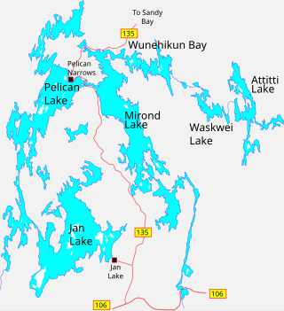
Jan Lake is a community on the south-eastern shore of Jan Lake on Doupe Bay in the north-eastern part of the Canadian province of Saskatchewan. The community has a Canadian Coast Guard wharf, provincial and private campgrounds, pubs, as well as many tourist lodges, which focus on fishing, camping, and private cabins. Access is from Highway 135 and Jan Lake Airport, which is located along Highway 135, near the intersection with Highway 106.
Fishing Lake is a closed basin freshwater lake in the Canadian province of Saskatchewan. The lake is 22 kilometres (14 mi) north of the town of Foam Lake, and 24 kilometres (15 mi) east of the town of Wadena and is accessed from Highways 5 and 310. The northern and eastern shore is in the RM of Sasman No. 336 and the southern and western shore is in the RM of Foam Lake No. 276. The north-east portion of the lake–on the east side of McCormick Bay–is designated as Fishing Lake Wildlife Refuge.

Buffalo Pound Lake is a eutrophic prairie lake in Saskatchewan, Canada, formed from glaciation about 10,000 years ago, on the Qu'Appelle River approximately 28 kilometres (17 mi) north of Moose Jaw and 11 kilometres (6.8 mi) north-east of Tuxford. The lake gets its name from the method used by First Nations people to capture the bison using the natural topography as corrals or buffalo pounds. Bison, once numbering more than 60 million on the prairies but almost extinct by 1900, were reintroduced into the area in 1972.

Shields is a resort village in the Canadian province of Saskatchewan within Census Division No. 11. It is on the shores of Blackstrap Lake in the Rural Municipality of Dundurn No. 314. It east of the town of Dundurn.

Lac La Ronge Provincial Park is located in the boreal forest of the north central part of the Canadian province of Saskatchewan within the Canadian Shield. Situated in the Churchill River system, this provincial park has close to 100 lakes and more than 30 canoe routes, many of which follow old fur trade routes. Summer activities include camping, hiking, boating, fishing, and swimming. In the winter, there's cross-country skiing, snowmobiling, and ice fishing. Saskatchewan's highest waterfall is in the park. Nistowiak Falls are located north of Lac La Ronge along the Rapid River.
Echo Lake is a lake along the course of the Qu'Appelle River in the Canadian province of Saskatchewan. Echo Lake is so named because of the echo heard by the First Nations while paddling on the lake. It is one of four lakes that make up the Fishing Lakes. Pasqua Lake is upstream and Mission Lake is downstream. The lake can be accessed by Highway 56 and Highway 210. In 1942, a 4 m (13 ft) high dam was built on the Qu'Appelle River at Echo Lake's outflow to control the lake's water levels.

Good Spirit Lake Provincial Park is a provincial park on the eastern side of the Canadian province of Saskatchewan. Founded in 1931, the park surrounds the western and southern shores of Good Spirit Lake and is one of Saskatchewan's six founding provincial parks. The park is in the RM of Good Lake No. 274, about 48 kilometres (30 mi) north of the city of Yorkton. Highway 47 runs along the western boundary and Highway 229 provides access to the park's amenities.

Christopher Lake is a recreational lake in the boreal forest ecozone in the Canadian province of Saskatchewan. It is located south-east of Emma Lake and Great Blue Heron Provincial Park in the central part of the province in the District of Lakeland No. 521. Access to Christopher Lake is from Highways 953 and 263 and it is about 42 km (26 mi) north of the city of Prince Albert.

