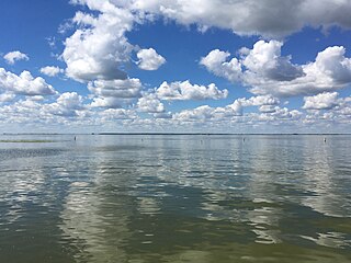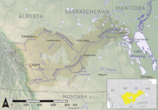
Cold Lake is a large lake in Central Alberta and Saskatchewan, Canada. The lake straddles the Alberta / Saskatchewan border, and has a water area of 373 km2 (144 sq mi). It is also one of the deepest lakes in Alberta with a maximum depth of 200.1 m (656 ft). It has around 24 known species of fish and is a major ice fishing lake. Cold Lake is also major stop for many migrating birds, and is home to one of the largest warbler populations in Alberta. A surface of 248 km2 (96 sq mi) lies in the province of Alberta.

Beaver River is a large river in east-central Alberta and central Saskatchewan, Canada. It flows east through Alberta and Saskatchewan and then turns sharply north to flow into Lac Île-à-la-Crosse on the Churchill River which flows into Hudson Bay.

Last Mountain Lake, also known as Long Lake, is a prairie lake formed from glaciation 11,000 years ago. It is located in south central Saskatchewan, Canada, about 40 kilometres (25 mi) north-west of the city of Regina. It flows into the Qu'Appelle River via Last Mountain Creek, which flows past Craven. It is approximately 93 km (58 mi) long, and 3 km (1.9 mi) wide at its widest point. It is the largest naturally occurring body of water in southern Saskatchewan. Only Lake Diefenbaker, which is man-made, is larger. The lake is a popular resort area for residents of south-eastern Saskatchewan.

Waterhen River is an east-flowing river in the north-west area of the Canadian province of Saskatchewan in the drainage basin of the Beaver River. It is north of and parallel to the east-flowing part of the Beaver River and joins the north-flowing part of that river. Most of the river and its drainage basin is at the southern edge of the boreal forest belt. While the river's source is Lac des Îles, its drainage basin reaches north into the Mostoos Hills and west well into the neighbouring province of Alberta.
Waterhen Lake is a lake in Meadow Lake Provincial Park in the Canadian province of Saskatchewan, located about 40 km (25 mi) north of the city of Meadow Lake. The lake is situated along the course of the Waterhen River in the boreal forest ecozone of Canada.

Oak Lake is a lake in the south-western part of the Canadian province of Manitoba in a region called Westman. Oak Lake is a kettle lake and is an aquifer supplier for numerous nearby residential areas and farms. The lake is in the RM of Sifton and sits at an elevation of 426 metres above sea level. Provincial Road 254 provides access to the lake.

Cold River is a river in the Canadian province of Saskatchewan. The river's source is Cold Lake, which is a large lake on the provincial border of Saskatchewan and Alberta, and its mouth is at the western end of Lac des Îles in Meadow Lake Provincial Park. It is an east flowing river and the entirety of its course is in Meadow Lake Provincial Park and the boreal forest.

Martineau River is a river in the Canadian provinces of Saskatchewan and Alberta. Its source is at Primrose Lake in north-western Saskatchewan and its mouth is at Cold Lake in Alberta. The river travels in a south-westerly direction through muskeg and the boreal forest ecozone of Canada The majority of the river and its tributaries are in Saskatchewan with only the final leg being in Alberta.
Lac des Îles is a lake in Meadow Lake Provincial Park in the Canadian Province of Saskatchewan in the boreal forest ecozone of Canada. The primary inflow is the Cold River and its outflow is the Waterhen River. The lake and associated rivers are part of the Hudson Bay drainage basin as the Waterhen River flows into Beaver River, which meets the Churchill River, a major river that flows into Hudson Bay, at Lac Île-à-la-Crosse.
Kimball Lake is a lake in Meadow Lake Provincial Park in the Canadian Province of Saskatchewan in the boreal forest ecozone of Canada. The lake is located near the centre of the park, north of the Waterhen River and Little Raspberry Lake and south of First Mustus Lake. Rusty and Greig Lakes are to the east. Several small streams feed into the lake and the outflow is at the southern shore, which feeds into the Waterhen River, a tributary of Beaver River. The Beaver River, in turn, flows north into Lac Île-à-la-Crosse and the Churchill River, a major tributary in the Hudson Bay drainage basin.
Matheson Lake is a lake in Meadow Lake Provincial Park in the Canadian Province of Saskatchewan in the boreal forest ecozone of Canada. The lake is located near the centre of the park, north of the Waterhen River, west of Vivian Lake and south of Peitahigan Lake. Several small streams feed into the lake and the outflow is at the southern shore, which feeds into the Waterhen River, a tributary of Beaver River. The Beaver River, in turn, flows north into Lac Île-à-la-Crosse and the Churchill River, a major tributary in the Hudson Bay drainage basin.
First Mustus Lake is a lake in Meadow Lake Provincial Park in the Canadian Province of Saskatchewan in the boreal forest ecozone of Canada. The lake is the first of four lakes in a row named Mustus in the Rusty Creek watershed. The other lakes are Second, Third, and Fourth Mustus. Rusty Creek and the lakes are part of the Waterhen River drainage basin. The Waterhen River is a tributary of the Beaver River, which flows north into Lac Île-à-la-Crosse and the Churchill River, a major tributary in the Hudson Bay drainage basin. Highway 224 provides access to both First and Second Mustus Lakes.
Peitahigan Lake is a lake in Meadow Lake Provincial Park in the Canadian Province of Saskatchewan in the boreal forest ecozone of Canada. The lake is one of six notable lakes in the Rusty Creek watershed. The other lakes include Rusty, First Mustus, Second Mustus, Third Mustus, and Fourth Mustus. Rusty Creek and the lakes are part of the Waterhen River drainage basin. The Waterhen River is a tributary of the Beaver River, which flows north into Lac Île-à-la-Crosse and the Churchill River, a major tributary in the Hudson Bay drainage basin.
Mistohay Lake is a lake in Meadow Lake Provincial Park in the Canadian Province of Saskatchewan in the boreal forest ecozone of Canada. The lake is part of the Waterhen River drainage basin. The Waterhen River is a tributary of the Beaver River, which flows north into Lac Île-à-la-Crosse and the Churchill River, a major tributary in the Hudson Bay drainage basin.

Rusty Creek is a river in the Canadian province of Saskatchewan. The river's source is First Mustus Lake, which is a lake in Meadow Lake Provincial Park, and its mouth is along the course of the Waterhen River. It is a south flowing river and the entirety of its course is in Meadow Lake Provincial Park and the boreal forest ecozone. Rusty Creek is a tributary of Waterhen River, which is a major tributary of Beaver River of the Churchill River and in the Hudson Bay drainage basin.

McDougal Creek is a river in the Canadian province of Saskatchewan. The river's source is at the southern end of Divide Lake at the northern end of Narrow Hills Provincial Park in a hilly plateau called Cub Hills. The landforms of the Cub Hills, such as the lakes, streams, steeply rolling hills, and flat lowlands, were formed over 10,000 years ago during the last ice age. The entire course of the river is in the boreal forest ecozone of Canada.

Nipekamew Creek is a creek in the boreal forest ecozone in the Canadian province of Saskatchewan. Its source is in muskeg approximately 20 kilometres west of Piprell Lake, near Highway 913. From the muskeg, the creek flows in a northerly direction through forests, rolling hills, glacier formed valleys, first into Stuart Lake, then Nipekamew Lake. The creek can be accessed from Highways 927, 913, and 912. After the creek leaves Stuart Lake, it follows the course of Highway 912 from there until it empties into Nipekamew Lake.

White Gull Creek is a river in the Canadian province of Saskatchewan. The river's source is White Gull Lake, near the south-western boundary of Narrow Hills Provincial Park and near the southern slopes of the Cub Hills. The river travels through boreal forest and muskeg en route to its mouth at the Torch River. The Torch River is a tributary of the Saskatchewan River as it flows into one of North America's largest inland fresh water deltas, the Saskatchewan River Delta. There are no communities nor settlements along the river.

Stewart Creek is a river in the east-central part of the Canadian province of Saskatchewan. The river's source is Lower Fishing Lake of the Cub Hills in Narrow Hills Provincial Park, and it travels south through boreal forest and muskeg en route to its mouth at the Torch River. The Torch River flows east to the Saskatchewan River, which is part of the Hudson Bay drainage basin. There are no communities nor settlements along the course of the river.
The Cub Hills are a hilly plateau located south-east of the geographical centre of the Canadian province of Saskatchewan. The hills are in the boreal forest ecozone of Canada and the landforms of the hills were shaped more than 10,000 years ago during last ice age. Throughout the Cub Hills, there are dozens of lakes and rivers and several parks. The Cubs Hills are 150 km (93 mi) north-east of Prince Albert and are in the Northern Saskatchewan Administration District and Census Division #18. Several highways criss-cross the plateau to provide access to the various parks and other amenities.


