The South Saskatchewan River is a major river in the Canadian provinces of Alberta and Saskatchewan. The river begins at the confluence of the Bow and Oldman Rivers in southern Alberta and ends at the Saskatchewan River Forks in central Saskatchewan. The Saskatchewan River Forks is the confluence of the South and North Saskatchewan Rivers and is the beginning of the Saskatchewan River.
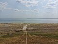
Old Wives Lake is a shallow endorheic salt lake in south central Saskatchewan, Canada, about 30 kilometres (19 mi) south-west of Moose Jaw. The lake is fed by the Wood River but seasonal water relatively flattened the terrain, and as such results in significant mudflats. A Migratory Bird Sanctuary was established at the lake on March 9, 1925. This lake, in conjunction with Reed Lake and Chaplin Lake, forms a site of hemispheric importance in the Western Hemisphere Shorebird Reserve Network. It was designated in April 1997, and is "one of the most important inland sites for migratory birds in North America". A variety of First Nations oral traditions explain the origin of the lake's name. At various times during the lake's human history, it has attracted interest from several First Nations tribes, duck hunters, military trainers, sodium sulfate producers, conservationists, and birdwatchers.
Landis is a village in the Canadian province of Saskatchewan within the Rural Municipality of Reford No. 379 and Census Division No. 13. The village is about 51 km (32 mi) south of Wilkie and about 128 km (80 mi) west from the City of Saskatoon on Highway 14. From 1907 to 1909, the post office at Section 23, Township 37, Range 18 west of the 3rd meridian, was known as Daneville. In 1925, Landis was a Canadian National Railway Station on the Grand Trunk Pacific Railway line.
Highway 1 is the Saskatchewan section of the Trans-Canada Highway mainland route. The total distance of the Trans-Canada Highway in Saskatchewan is 654 kilometres (406 mi). The highway traverses Saskatchewan from the western border with Alberta, from Highway 1, to the Manitoba border where it continues as PTH 1. The Trans-Canada Highway Act was passed on December 10, 1949. The Saskatchewan segment was completed August 21, 1957, and completely twinned on November 6, 2008. The speed limit along the majority of the route is 110 kilometres per hour (70 mph) with urban area thoroughfares slowing to a speed of 80–100 kilometres per hour (50–62 mph). Portions of the highway—the section through Swift Current, an 8-kilometre (5 mi) section east of Moose Jaw, and a 44-kilometre (27 mi) section between the West Regina Bypass and Balgonie—are controlled-access. Highway 1 serves as a major east–west transport route for commercial traffic. It is the main link between southern Saskatchewan's largest cities, and also serves as the province's main link to the neighbouring provinces of Alberta and Manitoba.

Chaplin Lake is a salt lake in the south-west corner of the Canadian province of Saskatchewan. The lake is in the Prairie Pothole Region of North America, which extends throughout three Canadian provinces and five U.S. states, and within Palliser's Triangle and the Great Plains ecoregion of Canada. Along the northern shore is the village of Chaplin, Chaplin Nature Centre, and a sodium sulphate mine owned and operated by Saskatchewan Mining and Minerals. The lake is divided into four sections by dykes built by the mining company. The Trans-Canada Highway runs along the northern shore and Highway 58 runs through the middle of the lake in a south to north direction.
Saskatchewan Highway 19 is a procincial highway in the Canadian province of Saskatchewan connecting Highway 15 northern extremity near Hawarden to Highway 18 at the southern extremity near Mankota. Highway 19 passes through major communities of Elbow, and Central Butte all in the south-west section of Saskatchewan; it is about 269 km (167 mi) long.
Highway 58 is a provincial highway in the Canadian province of Saskatchewan that handles approximately 100 vehicles per day. The highway runs from Highway 18 about 3 kilometres (1.9 mi) west of Fir Mountain north until Highway 1 / Highway 19 at Chaplin in the south-central region of the province. There are multiplexes of 1.6 kilometres (1.0 mi) with Highway 13, 300 metres (980 ft) with Highway 43, and 4.9 kilometres (3.0 mi) with Highway 363. The section from its southern terminus north to Shamrock is paved while north of Shamrock to Chaplin is gravel. The highway is about 132 kilometres (82 mi) long.

Manitou Lake is a salt lake located mostly in the RM of Manitou Lake No. 422 in the Canadian province of Saskatchewan, about 10 kilometres (6.2 mi) east of the provincial border with Alberta. The eastern shore of the lake is in the RM of Hillsdale No. 440. Manitou Lake is located in a region called the Prairie Pothole Region of North America, which extends throughout three Canadian provinces and five U.S. states. It is also within Palliser's Triangle and the Great Plains ecoregion. Manitou Lake is part of an Important Bird Area (IBA) of Canada that covers 699.66 km2 (270.14 sq mi) of land and serval neighbouring lakes.

The Quill Lakes is a wetland complex in Saskatchewan, Canada that encompasses the endorheic basin of three distinct lake wetlands: Big Quill Lake, Middle Quill Lake, and Little Quill Lake. On May 27, 1987, it was designated a wetland of international importance via the Ramsar Convention. It was the first Canadian site in the North American Waterfowl Management Plan, is a site in the International Biological Programme and Saskatchewan Heritage Marsh Program, and was designated a Western Hemisphere Shorebird Reserve Network site of International significance in May, 1994. The site is an important staging and breeding area for spring and fall migration of shorebirds. The site qualifies as an Important Bird Area (IBA) of Canada for its globally and nationally significant migratory and breeding populations of more than a dozen species of birds. The IBA is designated as Quill Lakes .

The Fauna of Saskatchewan include several diverse land and aquatic animal species. From the multiplicity of invertebrates and vertebrates, two have been chosen as symbols of Saskatchewan. Cenozoic vertebrate fossils reveal the geological evolution of the interior plains and its prehistoric biogeography. Today, Saskatchewan's ecosystems range from the sub-arctic tundra of the Canadian Shield in north Saskatchewan to aspen parkland, the Mid-Continental Canadian forests in the centre of the province and grassland prairie. Fauna inhabit areas unique to their own specific and varied breeding, foraging and nesting requirements. With a large land and water area, and small population density, the ecoregions of Saskatchewan provide important habitat for many animals, both endangered and not. Naturalists observing wildlife have enumerated shrinking and growing wildlife populations. They advocate programs and methods to preserve or re-introduce endangered species and identify programs of control for outbreaks of wildlife populations. A broad diversity of wildlife habitats are preserved as parks and reserves protecting the feeding and breeding grounds of protected and indigenous fauna of Saskatchewan.
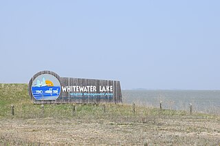
Whitewater Lake is a lake in the Canadian province of Manitoba located between Boissevain and Deloraine. It is an endorheic basin and more marsh than lake. Whitewater Lake was previously called White Lake due to the color of the salt flats exposed during dry periods. Whitewater Lake covers approximately 22,000 acres on average and only reaches depths of about 2 metres (6.6 ft). The lake is fed by several small streams which flow into it from the Turtle Mountains but has no natural outflow.
Last Mountain Lake National Wildlife Area is a National Wildlife Area (NWA) in the Canadian province of Saskatchewan. The protected area is in the Prairie Pothole Region of North America, which extends throughout three Canadian provinces and five U.S. states. It is also within Palliser's Triangle and the Great Plains ecoregion. The site is an Important Bird Area (IBA) of Canada, designated as Last Mountain Lake NWA .

Thunder Creek is a river in the Canadian province of Saskatchewan. The watershed of Thunder Creek is within the semi-arid Palliser's Triangle in south-central Saskatchewan. It begins at small, man-made reservoir near Lake Diefenbaker and flows in a south-easterly direction towards the city of Moose Jaw and the Moose Jaw River. The Moose Jaw River is a major tributary of the Qu'Appelle River For most of its course, Thunder Creek follows a valley called the Thunder Creek meltwater channel that was formed over 10,000 years ago near the end of the last ice age.

Plum Creek is the primary outflow for the Plum Lakes and travels in an easterly direction for about 28 kilometres until it meets up with the Souris River, which is part of the Hudson Bay drainage basin, at the community of Souris in the Canadian province of Manitoba. Plum Lakes and the beginning of Plum Creek are in the Rural Municipality of Sifton and the mouth is in the Municipality of Souris – Glenwood.

Foam Lake is a shallow lake in the aspen parkland ecoregion of the Canadian Province of Saskatchewan. It was named "Foam Lake" in 1882 by the Milligans because of the large amount of froth that forms on it. The lake and surrounding marsh are a protected area and important wildlife habitat. The primary inflows for the lake, Milligan Creek and Beckett Brook, originate to the south in the Touchwood Hills. From the north shore of the lake, Milligan Creek flows north-west into the salty Quill Lakes. The Quill Lakes are endorheic lakes as they have no outlet.
Wood River is a river in the Canadian province of Saskatchewan. It has its source in the Wood Mountain Hills of south-western Saskatchewan and flows in a north-easterly direction to its mouth at Old Wives Lake. Old Wives Lake is a salt water lake with no outflow. As a result, the drainage basin of Wood River is an endorheic one. Along the course of the river, there are several parks, historical sites, and small towns.

Willow Bunch Lake is a salt lake in the southern region of the Canadian province of Saskatchewan. The lake is in the Big Muddy Valley in a semi-arid region called Palliser's Triangle. There are no communities nor public facilities at the lake. The nearest town is Willow Bunch at 8 kilometres (5.0 mi) to the south and access is from Highway 36. The entire lake and its shoreline has been designated an Important Bird Area (IBA) of Canada.
Fife Lake is a fresh water prairie lake in the Canadian province of Saskatchewan. It is in the south-central part of the province at the eastern end of the Wood Mountain Hills. The entire lake and its shoreline is designated an Important Bird Area (IBA) of Canada to protect the nationally endangered piping plover. While there are no communities along the lake's shore, there is a park and campground at the southern end. Nearby communities include Fife Lake, Rockglen, and Lisieux. Access is from Highway 18.

Bigstick Lake is a shallow endorheic alkali lake in the south-west region of the Canadian province of Saskatchewan. The lake was named after the Big Stick Trail that ran between the town of Maple Creek and the South Saskatchewan River. The trail was notable for a large, solitary tree along its route. The lake and its drainage basin are in a semi-arid region known as Palliser's Triangle.
Eyehill Creek is a river in the Canadian provinces of Alberta and Saskatchewan. The river begins at Sounding Lake in Alberta and flows east and north into Manitou Lake in Saskatchewan. Eyehill Creek is the primary inflow for Manitou Lake, which has no outflow. The Manitou Lake watershed is a large endorheic basin between the Battle River watershed to the north and the South Saskatchewan River watershed to the south.