
Turtle Lake is a lake in the west-central part of the Canadian province of Saskatchewan. It is fairly long while also narrow. The closest town is Livelong and the closest cities are North Battleford, Meadow Lake, and Lloydminster. Turtle Lake is a heavily utilized recreational lake with campgrounds and small resort villages along its shores. Access to the lake and its amenities is from Highways 697 and 795.

Macklin is a town in the Rural Municipality of Eye Hill No. 382, Saskatchewan, Canada. The population was 1,247 at the 2021 Canadian census. The town is located on Highway 14 and Highway 31 about 5 kilometres (3.1 mi) east of the provincial border with Alberta, and is situated near one of the most productive oil and natural gas producing fields in the province.
The Rural Municipality of Leask No. 464 is a rural municipality (RM) in the Canadian province of Saskatchewan within Census Division No. 16 and SARM Division No. 5. It is located west of the city of Prince Albert.

Wakaw Lake is a lake in the RM of Hoodoo No. 401 in the central part of the Canadian province of Saskatchewan. It is about 102 kilometres (63 mi) north-east of Saskatoon and 73 kilometres (45 mi) south of Prince Albert. It takes its name from a Cree word meaning "crooked", referring to the curved shape of the lake. The lake is known in Cree as ᐚᑳᐤ ᓵᑲᐦᐃᑲᐣ wâkâw sâkahikan. Wakaw Lake is the source of the Carrot River, which is a 300-kilometre (190 mi) long river that parallels the South Saskatchewan and Saskatchewan Rivers before meeting the Saskatchewan River at The Pas, Manitoba.

St. Brieux is a town in the Canadian province of Saskatchewan. It is located near Highway 368 and Highway 779. St. Brieux is located north of the village of Lake Lenore on the eastern shore of St. Brieux Lake. St. Brieux Regional Park and Golf Course is adjacent to the west side of the town.
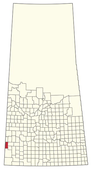
The Rural Municipality of Enterprise No. 142 is a rural municipality (RM) in the Canadian province of Saskatchewan within Census Division No. 8 and SARM Division No. 3. It is located in the southwest portion of the province.

Meota is a village in the Canadian province of Saskatchewan within the Rural Municipality of Meota No. 468 and Census Division No. 17. The village name is derived from the Cree phrase Meotate or Mo-Was-In-Ota, meaning "good place to camp" or "it is good here."

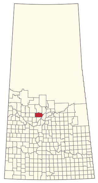
The Rural Municipality of Britannia No. 502 is a rural municipality (RM) in the Canadian province of Saskatchewan within Census Division No. 17 and SARM Division No. 6. It is located in the west-central portion of the province.

The Rural Municipality of Spy Hill No. 152 is a rural municipality (RM) in the Canadian province of Saskatchewan within Census Division No. 5 and SARM Division No. 1. It is located in the east-central portion of the province.

The Rural Municipality of Snipe Lake No. 259 is a rural municipality (RM) in the Canadian province of Saskatchewan within Census Division No. 8 and SARM Division No. 3.

Saskatchewan Landing Provincial Park is a provincial park in the Canadian province of Saskatchewan. It is in the valley of the South Saskatchewan River at the western end of Lake Diefenbaker in the RM of Saskatchewan Landing No. 167, about 50 kilometres (31 mi) north of Swift Current. The park is 5,735 hectares in size.
Saginas Lake, is a lake in the east-central part of the Canadian province of Saskatchewan in the boreal forest ecozone of Canada. It is located along the course of the Pepaw River and is situated in the Porcupine Hills. It is within Saskatchewan's Porcupine Provincial Forest and a portion of Porcupine Hills Provincial Park is on the eastern shore of the lake. Upstream along the Pepaw River is Pepaw and McBride Lakes—both of which lakes also have recreation sites that are part of Porcupine Hills Provincial Park. The lake and park are accessed from Highway 982, also known as Little Swan Road.
Antelope Lake is an endorheic lake in the south-west corner of the Canadian province of Saskatchewan. The lake is in the Prairie Pothole Region of North America, which extends throughout three Canadian provinces and five U.S. states, and within Palliser's Triangle and the Great Plains ecoregion of Canada. The primary inflow for the lake is Bridge Creek, which originates to the south in the Cypress Hills at an elevation of over 1,000 metres (3,300 ft) above sea level.

Good Spirit Lake Provincial Park is a provincial park on the eastern side of the Canadian province of Saskatchewan. Founded in 1931, the park surrounds the western and southern shores of Good Spirit Lake and is one of Saskatchewan's six founding provincial parks. The park is in the RM of Good Lake No. 274, about 48 kilometres (30 mi) north of the city of Yorkton. Highway 47 runs along the western boundary and Highway 229 provides access to the park's amenities.
York Lake, formally known as Pebble Lake, is a lake in the south-east region of the Canadian province of Saskatchewan. It is a shallow, narrow lake located about 5 kilometres (3.1 mi) south of the city of Yorkton in the Prairie Pothole Region of North America, which extends throughout three Canadian provinces and five U.S. states, and within Palliser's Triangle and the Great Plains ecoregion of Canada.
The Battlefords Provincial Park is a recreational provincial park in the Canadian Province of Saskatchewan. It is about 39 kilometres (24 mi) north of the city of North Battleford in the RM of Meota No. 468 on Jackfish Lake. Highway 4 runs north from North Battleford to the park and Highway 204 runs through the park providing access to the amenities.
Brightsand Lake is a lake in the Canadian Province of Saskatchewan. It is located in the Rural Municipality of Mervin No. 499 in the west-central part of the province in the aspen parkland ecoregion. Brightsand Creek–located on the western side of the lake–is the outflow and it flows in a southerly direction into Turtlelake River, which is a tributary of the North Saskatchewan River. Turtle Lake is about 9.5 kilometres (5.9 mi) to the east and the Meadow Lake Escarpment is to the north-east.
Candle Lake Provincial Park is a provincial park in the central region of the Canadian province of Saskatchewan. Prior to the park's establishment in 1986, it was a provincial recreation site. Located in the Rural Municipality of Paddockwood No. 520, Candle Lake Provincial Park surrounds most of Candle and Torch Lakes in the boreal forest ecozone of Canada. The park has a variety of activities including camping, boating, fishing, swimming, mini golfing, hiking, and golfing. Around the lake there are also boat launches and several marinas. Natural attractions include a purple sand beach, sand dunes, mature forests, crystal clear lake water, and several natural sand beaches.
Makwa Lake Provincial Park is a recreational provincial park in the west-central region of the Canadian province of Saskatchewan in the transition zone between parkland and boreal forest. The park was established in 1986 and is centred around the lakes of Big Jumbo, Little Jumbo, and Makwa. Prior to its establishment, the park was a provincial recreation site. The main entrance to Makwa Lake Park is at the south-east corner of Makwa Lake about 3 kilometres (1.9 mi) west of the village of Loon Lake. Access is from Highway 699.

Eagle Creek is a river in the Canadian province of Saskatchewan. The watershed of Eagle Creek is within the semi-arid Palliser's Triangle and is the major drainage system in mid-western Saskatchewan between the South and North Saskatchewan Rivers. Eagle Creek begins at the eastern end of Eaglehill Lake and travels through a glacier-cut valley in the moist, mixed grasslands ecozone of Canada en route to the North Saskatchewan River. The North Saskatchewan River merges with the South Saskatchewan River farther downstream to become the Saskatchewan River.

