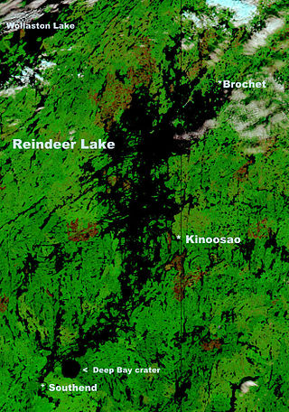
Reindeer Lake is a large lake in Western Canada located on the border between north-eastern Saskatchewan and north-western Manitoba, with the majority in Saskatchewan. The name of the lake appears to be a translation of the Algonquian name. It is the 24th largest lake in the world by area, as well as being the second-largest lake in Saskatchewan and the ninth largest in Canada. Eight percent of the lake lies in Manitoba while 92% of the lake is in Saskatchewan.

Avonlea is a village in the Canadian province of Saskatchewan within the RM of Elmsthorpe No. 100 and Census Division No. 2. The village is approximately 82 kilometres (51 mi) south-west of the city of Regina. The Southern Rails Cooperative maintains its head office in the village.

The Grant Devine Dam, formerly Alameda Dam, is an embankment dam located in the Canadian province near Alameda and Oxbow. It was constructed in 1994 to control flows on Moose Mountain Creek and Souris River. It provides flood protection and irrigation for this area of Saskatchewan, along with protection for Minot, North Dakota. The Grant Devine Reservoir provides opportunities for recreational use such as boating and fishing. At the full supply level of 562 metres (1,844 ft), the reservoir holds 105,000,000 m3 (3.7×10⁹ cu ft) of water. The project is owned and operated by the Saskatchewan Water Security Agency (formerly Saskatchewan Watershed Authority).
Candle Lake is a reservoir in the central part of the Canadian province of Saskatchewan in the boreal forest, approximately 80 kilometres (50 mi) north-east of Prince Albert. A dam completed in 1979 at the southern end of the lake regulates water levels; several small creeks feed into the lake and Torch River flows out of the lake at the dam. Candle Lake Provincial Park surrounds most of the lake and the resort village of Candle Lake is at the southern end.

Redberry Lake is a kettle salt lake near Hafford in the Canadian province of Saskatchewan. Named after the buffaloberry, it is a medium-sized saline lake within an area characterized by mostly fresh water aquatic environments. The lake makes up the core protected area of the Redberry Lake (UNESCO) Biosphere Reserve and is a federal bird sanctuary of the same name. It is also an Important Bird Area (IBA) of Canada and its northern most island is the location of the provincial Redberry Wildlife Refuge. A small regional park is situated at the north-west corner of the lake. The countryside surrounding Redberry Lake is typical of the aspen parkland biome of which it is a part.

Lac la Ronge is a glacial lake in the Canadian province of Saskatchewan. It is the fifth largest lake in the province and is approximately 250 kilometres (160 mi) north of Prince Albert, on the edge of the Canadian Shield. La Ronge, Air Ronge, and the Lac La Ronge First Nation are on the western shore. The lake is a popular vacation spot. Recreational activities include fishing, boating, canoeing, hiking, and camping.

Blackstrap Lake is a man-made reservoir in central Saskatchewan, Canada, south of Saskatoon in the Rural Municipality of Dundurn No. 314. The lake was created as a reservoir in 1967, as part of the Saskatoon South East Water Supply System. Blackstrap Lake has an area of 1,200 ha and is generally used to support irrigation, and the industrial and municipal water supply.
Crooked Lake is a recreational lake located in the south-eastern region of the Canadian province of Saskatchewan. It is part of a chain of lakes in the Qu'Appelle Valley and, like many of the other lakes in the valley, there's a dam at the eastern end that controls water levels.

The Whitesand River is a tributary of the Assiniboine River and finds its headwaters at Whitesand Lake near Invermay in east-central Saskatchewan. Its mouth can be found at its confluence with the Assiniboine River near Kamsack.

Spirit Creek is a river located in the Assiniboine River watershed in the Canadian province of Saskatchewan. It begins east of Rama and flows south-east into the north end of Good Spirit Lake. Along its route, it crosses Highway 5 and the CN Railway 3 kilometres (2 mi) west of Buchanan. Just over 3 kilometres (2 mi) south of Buchanan, it crosses Highway 47 and flows into Patterson Lake. From Patterson Lake, it empties into the north end of Good Spirit Lake.

McDonald Lake, also known as Rafferty Reservoir, is a reservoir in the south-eastern part of the Canadian province of Saskatchewan. It was created when the Rafferty Dam was built on the Souris River in 1994. Before the dam was built that flooded the Souris Valley, McDonald Lake was a small lake and marsh on the valley floor adjacent to the Souris River.
Moosomin Lake, also known as Moosomin Reservoir, is a man-made lake in south-eastern part of the Canadian province of Saskatchewan. Created by the damming of Pipestone Creek in 1954, Moosomin Lake is located about 10 kilometres (6.2 mi) south of the town of Moosomin and is in the Souris River watershed. The reservoir's uses include irrigation, water supply, and recreation. Moosomin Lake Regional Park is on lake's western shore.

Avonlea Creek is a river in the southern part of the Canadian province of Saskatchewan. It is in a region called the Prairie Pothole Region of North America, which extends throughout three Canadian provinces and five U.S. states. It is also within Palliser's Triangle and the Great Plains ecoregion. Avonlea Creek is a main tributary of the Moose Jaw River, which is part of the Upper Qu'Appelle Watershed and the Hudson Bay drainage basin.
Echo Lake is a lake along the course of the Qu'Appelle River in the Canadian province of Saskatchewan. Echo Lake is so named because of the echo heard by the First Nations while paddling on the lake. It is one of four lakes that make up the Fishing Lakes. Pasqua Lake is upstream and Mission Lake is downstream. The lake can be accessed by Highway 56 and Highway 210. In 1942, a 4-metre (13 ft) high dam was built on the Qu'Appelle River at Echo Lake's outflow to control the lake's water levels. In the summer of 2024, Saskatchewan's Water Security Agency begun "interim repairs" on Echo Lake Dam to "improve safety and extend the dam's life until a replacement can be completed".

Crescent Creek is a river in the south-east region of the Canadian province of Saskatchewan. The river begins in the Beaver Hills and flows in an easterly direction into Crescent Lake. Crescent Creek is a tributary of Yorkton Creek, which flows north into the Whitesand River–a tributary of the Assiniboine River.
Thomson Lake is a reservoir in the Canadian province of Saskatchewan along the course of Wood River in the Old Wives Lake closed watershed. The lake was created in 1958 for irrigation and consumption with the damming of Wood River. It was named after Dr Leonard Thomson who was the director of the Prairie Farm Rehabilitation Administration (PFRA) at the time.

Nickle Lake is a man-made reservoir in the Canadian province of Saskatchewan. It was created with the construction of a dam across the Souris River in the 1950s to supply water to the city of Weyburn. In the 1980s, the dam—christened Albert Douglas Dam—was expanded thereby increasing the size of the lake.
Bradwell Reservoir is a man-made reservoir in the Canadian province of Saskatchewan in the Rural Municipality of Blucher No. 343. The reservoir was built as part of the South Saskatchewan River Project. That project involved the damming of the South Saskatchewan River with the Gardiner and Qu'Appelle River Dams creating Lake Diefenbaker. From Lake Diefenbaker, a series of aqueducts were built allowing for irrigation and the creation of several reservoirs, including Bradwell Reservoir. The reservoir is owned and operated by the Saskatchewan Water Security Agency. Bradwell Reservoir supplies water to the Nutrien Allan Potash Mine near Allan.
Zelma Reservoir is a reservoir in the Canadian province of Saskatchewan in the Rural Municipality of Morris No. 312. It is about 17 kilometres (11 mi) east-southeast of the town of Colonsay. The reservoir was built in 1967 as part of South Saskatchewan River Project. That project, originating at Gardiner Dam of Lake Diefenbaker, involved the building of aqueducts, canals, and a series of reservoirs to supply water for irrigation, consumption, and industry. Other reservoirs in the system include Broderick Reservoir, Brightwater Reservoir, Indi Lake, Blackstrap Lake, Bradwell Reservoir, and Dellwood Reservoir.
Dellwood Reservoir is a reservoir in the Canadian province of Saskatchewan in the Rural Municipality of Usborne No. 310. The reservoir was built along the course of Dellwood Brook as part of South Saskatchewan River Project. That project, originating at Gardiner Dam of Lake Diefenbaker, involved the building of aqueducts and a series of reservoirs to supply water for irrigation, consumption, and industry. The reservoir is about 22 kilometres (14 mi) north-east of the town of Watrous and access is from Highway 668.

