Good Spirit Lake

Last updated

Good Spirit Lake
Good Spirit Lake.jpg
Good Spirit Lake
Canada Saskatchewan relief location map.jpg
Red pog.svg
Good Spirit Lake
Location in Saskatchewan
Canada relief map 2.svg
Red pog.svg
Good Spirit Lake
Good Spirit Lake (Canada)
Location RM of Good Lake No. 274, Flag of Saskatchewan.svg  Saskatchewan
Coordinates 51°34′00″N102°40′02″W / 51.5667°N 102.6671°W / 51.5667; -102.6671
Primary inflows Spirit Creek
Catchment area Whitesand River
Basin  countriesFlag of Canada (Pantone).svg  Canada
Surface area4,501 ha (11,120 acres)
Max. depth10 m (33 ft)
Shore length140 km (25 mi)
Surface elevation481 m (1,578 ft)
Settlements
1 Shore length is not a well-defined measure.

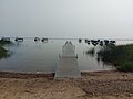
Good Spirit Lake [1] is a lake on the eastern side of the Canadian province of Saskatchewan. It is a shallow lake notable for its naturally sandy beaches, parks, and sand dunes. One of Saskatchewan's six founding provincial parks, Good Spirit Lake Provincial Park, surrounds the western and southern shores of the lake. The lake is in the RM of Good Lake No. 274 and Yorkton, 48 kilometres (30 mi) to the south, is the nearest city. [2] [3] The hamlets of Burgis Beach [4] and Canora Beach–the only two communities on the lake–are located on the eastern shore. [5] The southern shore of the lake is accessed from Highway 229 and the northern shore is accessed from Highway 651. Highway 47 runs north to south west of the lake and Good Spirit Lake Provincial Park.

Contents

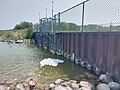
Good Spirit Lake's main inflow, Spirit Creek, flows into the lake at the northern end. At the southern end of the lake is a dam that was built to regulate water levels. The lake's outflow is from a channel that leads away from the dam and into a tributary of the Whitesand River. [6]

History

In the winter of 1774–75, Matthew Cocking of the Hudson's Bay Company stayed at the lake and called it "Witch Lake". In the late 1800s, the local postmaster Robert Russell Smith named it Devil's Lake as the naming was a misinterpretation of the Cree / Salteaux word "manitow", which actually means "good spirit". The European settlers of the time could not believe a spirit could be "good" so the term "Devil" was used. The local post office continued to use the name Devil's Lake until it closed in 1954. [7]

Near the end of the last ice age, a river ran through the area now occupied by the lake. The river had deposited the sands that make up the lake's sandy shores and bottom and the dunes at the southern end of the lake. The dunes, which reach a height of up to five storeys, are within Good Spirit Provincial Park and there are interpretive hiking trails that traverse them. [8]

Parks and recreation

Good Spirit Lake Provincial Park [9] is located along the lake's entire western and southern shores and it has three campgrounds with over 200 sites, a beach, picnic area, boat launch, and hiking trails. [10] A section of the Trans Canada Trail winds its way around the park and the Dune Discovery Interpretive Trail goes through sand dunes. [11] [12] In the winter season, many of the trails are groomed for cross-country skiing and snowmobiling.

Other parks, campgrounds, resorts on Good Spirit Lake include:

Fish species

Fish commonly found in the lake include northern pike, perch, and walleye. [20] [21] [22]

See also

Related Research Articles

<span class="mw-page-title-main">Turtle Lake (Saskatchewan)</span> Lake in Saskatchewan, Canada

Turtle Lake is a lake in the west-central part of the Canadian province of Saskatchewan. It is fairly long while also narrow. The closest town is Livelong and the closest cities are North Battleford, Meadow Lake, and Lloydminster. Turtle Lake is a heavily utilized recreational lake with campgrounds and small resort villages along its shores. Access to the lake and its amenities is from Highways 697 and 795.

Little Bear Lake is a lake in the boreal forest ecozone in the Canadian province of Saskatchewan. The lake is in a hilly plateau called Cub Hills and the landforms, such as the lakes and streams, of the Cub Hills were formed over 10,000 years ago during the last ice age. Little Bear Lake is accessed from the Hanson Lake Road, which runs along the eastern side of the lake, and by a small airport called Little Bear Lake Airport.

<span class="mw-page-title-main">Candle Lake (Saskatchewan)</span> Lake in Saskatchewan, Canada

Candle Lake is a reservoir in the central part of the Canadian province of Saskatchewan in the boreal forest, approximately 80 kilometres (50 mi) north-east of Prince Albert. A dam completed in 1979 at the southern end of the lake regulates water levels; several small creeks feed into the lake and Torch River flows out of the lake at the dam. Candle Lake Provincial Park surrounds most of the lake and the resort village of Candle Lake is at the southern end.

<span class="mw-page-title-main">Meadow Lake Provincial Park</span> Provincial park in Saskatchewan, Canada

Meadow Lake Provincial Park is a northern boreal forest provincial recreational park along the Waterhen and Cold Rivers in the Canadian province of Saskatchewan. The park was founded on 10 March 1959, is the largest provincial park in Saskatchewan, and encompasses over 25 lakes in an area of 1,600 km2 (620 sq mi). The park was named "Meadow Lake" after the city of Meadow Lake and Meadow Lake. The city and the lake are not in the park and are located about 40 kilometres (25 mi) south-east of the nearest park entrance, which is about 5 kilometres (3.1 mi) north of Dorintosh. The length of the park stretches about 113 kilometres (70 mi) from Cold Lake on the Saskatchewan / Alberta border in the west to the eastern shore of Waterhen Lake in the east.

<span class="mw-page-title-main">Blackstrap Provincial Park</span> Provincial park in Saskatchewan, Canada

Blackstrap Provincial Park is a provincial park in the Canadian province of Saskatchewan in the RM of Dundurn No. 314. Prior to the park's establishment in 1986, it was a provincial recreation site. The park runs along the eastern shore of Blackstrap Lake and consists of a conservation area, campground, beaches, Mount Blackstrap, cross country ski trails, biking and hiking trails, and several picnicking areas. It is about 8.5 kilometres (5.3 mi) east of the town of Dundurn and accessed via Highway 211. Mount Blackstrap is a man-made mountain built as a ski hill for the 1971 Canada Winter Games. It continued to operate as a ski hill until 2007.

Burgis Beach is a hamlet in the Canadian province of Saskatchewan.

<span class="mw-page-title-main">Narrow Hills Provincial Park</span> Provincial park in Saskatchewan, Canada

Narrow Hills Provincial Park is a northern boreal forest provincial recreational park in the Canadian province of Saskatchewan. It is located in a hilly plateau called the Cub Hills and contains several recreational facilities and over 25 accessible lakes within its boundaries. The geographical features of the park, including the lakes, valleys, and lowlands were formed over 10,000 years ago during the last ice age. The town of Smeaton is the closest community and it is located 70 kilometres (43 mi) to the south.

<span class="mw-page-title-main">Rural Municipality of Good Lake No. 274</span> Rural municipality in Saskatchewan, Canada

The Rural Municipality of Good Lake No. 274 is a rural municipality (RM) in the Canadian province of Saskatchewan within Census Division No. 9 and SARM Division No. 4.

<span class="mw-page-title-main">Echo Valley Provincial Park</span> Provincial park in Saskatchewan, Canada

Echo Valley Provincial Park is a provincial park in the Canadian province of Saskatchewan, located west of the town of Fort Qu'Appelle in the Qu'Appelle Valley between Echo Lake and Pasqua Lake in the RM of North Qu'Appelle No. 187. The three main roads to access the park are Highways 210, 56, and 727.

<span class="mw-page-title-main">Lac la Plonge</span> Lake in Saskatchewan, Canada

Lac la Plonge is a glacial lake in the Canadian province of Saskatchewan in the basin of the Beaver River, near Lac Île-à-la-Crosse. It is located in the boreal forest near the Canadian Shield. On the lake's northern shore, the community of Lac La Plonge, a resort, and campgrounds are accessed via Highway 165.

<span class="mw-page-title-main">Spirit Creek</span> River in Saskatchewan, Canada

Spirit Creek is a river located in the Assiniboine River watershed in the Canadian province of Saskatchewan. It begins east of Rama and flows south-east into the north end of Good Spirit Lake. Along its route, it crosses Highway 5 and the CN Railway 3 kilometres (2 mi) west of Buchanan. Just over 3 kilometres (2 mi) south of Buchanan, it crosses Highway 47 and flows into Patterson Lake. From Patterson Lake, it empties into the north end of Good Spirit Lake.

Greenwater Lake Provincial Park is a provincial park in the Canadian province of Saskatchewan. It is located on the eastern side of the province in the Porcupine Hills on Highway 38. The closest town, Porcupine Plain, is about 28 kilometres (17 mi) to the north-east of the park visitor centre. Founded on 19 February 1932, Greenwater is one of the oldest provincial parks in Saskatchewan. The original six parks were established in 1931 and Greenwater Provincial Park was added one year later. In 1964, the park was expanded to its current size.

Danielson Provincial Park is located at the northern end of Lake Diefenbaker in the southern part of the Canadian province of Saskatchewan. The park surrounds the Gardiner Dam, which was built in 1967 and is among the largest embankment dams in Canada and the world. The South Saskatchewan River flows north beyond the park, towards Outlook and Saskatoon. Saskatchewan Highways 44, 45, and 219 provide access to the park. SaskPower's Coteau Creek Hydroelectric Station is located near the park.

<span class="mw-page-title-main">Saskatchewan Landing Provincial Park</span> Provincial park in Saskatchewan, Canada

Saskatchewan Landing Provincial Park is a provincial park in the Canadian province of Saskatchewan. It is located in the valley of the South Saskatchewan River at the western end of Lake Diefenbaker in the RM of Saskatchewan Landing No. 167, about 50 kilometres (31 mi) north of Swift Current. The park is 5,735 ha in size.

<span class="mw-page-title-main">Good Spirit Lake Provincial Park</span> Provincial park in Saskatchewan, Canada

Good Spirit Lake Provincial Park is a provincial park on the eastern side of the Canadian province of Saskatchewan. Founded in 1931, the park surrounds the western and southern shores of Good Spirit Lake and is one of Saskatchewan's six founding provincial parks. The park is in the RM of Good Lake No. 274, about 48 kilometres (30 mi) north of the city of Yorkton. Highway 47 runs along the western boundary and Highway 229 provides access to the park's amenities.

The Battlefords Provincial Park is a recreational provincial park in the Canadian Province of Saskatchewan. It is about 39 kilometres (24 mi) north of the city of North Battleford in the RM of Meota No. 468 on Jackfish Lake. Highway 4 runs north from North Battleford to the park and Highway 204 runs through the park providing access to the amenities.

Candle Lake Provincial Park is a provincial park in the central region of the Canadian province of Saskatchewan. Prior to the park's establishment in 1986, it was a provincial recreation site. Located in the Rural Municipality of Paddockwood No. 520, Candle Lake Provincial Park surrounds most of Candle and Torch Lakes in the boreal forest ecozone of Canada. The park has a variety of activities including camping, boating, fishing, swimming, mini golfing, hiking, and golfing. Around the lake there are also boat launches and several marinas. Natural attractions include a purple sand beach, sand dunes, mature forests, crystal clear lake water, and several natural sand beaches.

Douglas Provincial Park is a provincial park in the Canadian province of Saskatchewan. Established in 1973, it is named after Tommy Douglas, the seventh premier of Saskatchewan and father of Canada's first single-payer, universal health care programme. The park is located along the Gordon McKenzie Arm of Lake Diefenbaker and at the Qu'Appelle River Dam, which is the source of the Qu'Appelle River. The closest community is Elbow and access to the park is from Highway 19.

Great Blue Heron Provincial Park is a recreational park in the central region of the Canadian province of Saskatchewan in the boreal forest ecozone of Canada. It is adjacent to the eastern boundary of Prince Albert National Park, about 50 kilometres (31 mi) north of the city of Prince Albert. The provincial park was established in 2013 from two pre-existing provincial recreation sites – Emma Lake and Anglin Lake Recreation Sites – and the addition of a large tract of Crown land.

Lucien Lake is a small recreational lake in the Canadian province of Saskatchewan. It is located in the RM of Three Lakes No. 400 in the aspen parkland ecoregion of Canada. On the lake's south-eastern shore is a regional park and to the east of that is the village of Middle Lake. Along the western shore are houses and Prairie Sky Resort campground. Access to the lake and its amenities is from Highway 777, which connects to Highway 20.

References

  1. "Good Spirit Lake". Canadian Geographical Names Database. Government of Canada. Retrieved 12 May 2022.
  2. "Good Spirit Lake Fishing Map". Gps Nautical Charts. Bist LLC. Retrieved 12 May 2022.
  3. "Good Spirit Lake". Geoview.info. Geoview. Retrieved 12 May 2022.
  4. "Burgis Beach". Tourism Saskatchewan. Government of Saskatchewan. Retrieved 12 May 2022.
  5. "Canora Beach Resort". Tourism Saskatchewan. Government of Saskatchewan. Retrieved 12 May 2022.
  6. "Good Spirit Lake Scour Hole". Assiniboine Watershed. AWSA. Retrieved 12 May 2022.
  7. Hayward, Debbie (4 July 2012). "Names have a past". SaskToday. Glacier Media Group. Retrieved 12 May 2022.
  8. "Good Spirit Dunes Discovery Trail". All Trails. AllTrails, LLC. Retrieved 12 May 2022.
  9. "Good Spirit Lake Provincial Park". Canadian Geographical Names Database. Government of Canada. Retrieved 12 May 2022.
  10. "Good Spirit Lake Provincial Park". Tourism Saskatchewan. Government of Saskatchewan. Retrieved 12 May 2022.
  11. "Good Spirit Lake Provincial Park Trails". Tourism Saskatchewan. Government of Saskatchewan. Retrieved 12 May 2022.
  12. "Good Spirit Lake". BRMB. Mussio Ventures Ltd. Retrieved 12 May 2022.
  13. "Good Spirit Bible Camp". Good Spirit Bible Camp. Retrieved 12 May 2022.
  14. "Donald Gunn". Geoview.info. Retrieved 12 May 2022.
  15. "Sandy Beach, Good Spirit Lake". My Sandy Beach. KD Butz Developments Inc. Retrieved 12 May 2022.
  16. "Parkland Resort". Campgrounds of Canada. Campgrounds of Canada. Retrieved 12 May 2022.
  17. "Canora Beach Resort". Good Spirit Lake. Canora Beach Developments Ltd. Retrieved 12 May 2022.
  18. "Bella Sands Resort". Bella Sands Resort. Bella Sands Resort. Retrieved 12 May 2022.
  19. Daniels, Calvin (11 July 2020). "Petting Zoo popular place for youngsters". SaskToday. Glacier Media. Retrieved 12 May 2022.
  20. "Good Spirit Lake". Angler's Atlas. Angler's Atlas. Retrieved 12 May 2022.
  21. "Fishing in Good Spirit Lake". FishBrain. Fishbrain. Retrieved 12 May 2022.
  22. Daniels, Calvin (5 September 2012). "Good Spirit not so good for shore fishing". SaskToday. No. Week XVI. Glacier Media Group. Retrieved 12 May 2022.