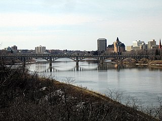
The South Saskatchewan River is a major river in the Canadian provinces of Alberta and Saskatchewan. The river begins at the confluence of the Bow and Oldman Rivers in southern Alberta and ends at the Saskatchewan River Forks in central Saskatchewan. The Saskatchewan River Forks is the confluence of the South and North Saskatchewan Rivers and is the beginning of the Saskatchewan River.
Landis is a village in the Canadian province of Saskatchewan within the Rural Municipality of Reford No. 379 and Census Division No. 13. The village is about 51 km (32 mi) south of Wilkie and about 128 km (80 mi) west from the City of Saskatoon on Highway 14. From 1907 to 1909, the post office at Section 23, Township 37, Range 18 west of the 3rd meridian, was known as Daneville. In 1925, Landis was a Canadian National Railway Station on the Grand Trunk Pacific Railway line.

Lake Diefenbaker is a reservoir and bifurcation lake in southern part of the Canadian province of Saskatchewan. It was formed by the construction of Gardiner Dam and the Qu'Appelle River Dam across the South Saskatchewan and Qu'Appelle Rivers respectively. Construction began in 1959 and the lake was filled in 1967. The lake is 225 kilometres (140 mi) long with approximately 800 kilometres (500 mi) of shoreline. It has a maximum depth of 66 metres (217 ft), while the water levels regularly fluctuate 3–9 metres (9–27 feet) each year. The flow of the two rivers is now regulated with a considerable portion of the South Saskatchewan diverted into the Qu'Appelle. Prior to the dams' construction, high water levels in the South Saskatchewan would frequently cause dangerous ice conditions downstream in Saskatoon while the Qu'Appelle would frequently dry up in the summer months.

Chaplin Lake is a salt lake in the south-west corner of the Canadian province of Saskatchewan. The lake is in the Prairie Pothole Region of North America, which extends throughout three Canadian provinces and five U.S. states, and within Palliser's Triangle and the Great Plains ecoregion of Canada. Along the northern shore is the village of Chaplin, Chaplin Nature Centre, and a sodium sulphate mine owned and operated by Saskatchewan Mining and Minerals. The lake is divided into four sections by dykes built by the mining company. The Trans-Canada Highway runs along the northern shore and Highway 58 runs through the middle of the lake in a south to north direction.

Manitou Lake is a salt lake located mostly in the RM of Manitou Lake No. 422 in the Canadian province of Saskatchewan, about 10 kilometres (6.2 mi) east of the provincial border with Alberta. The eastern shore of the lake is in the RM of Hillsdale No. 440. Manitou Lake is located in a region called the Prairie Pothole Region of North America, which extends throughout three Canadian provinces and five U.S. states. It is also within Palliser's Triangle and the Great Plains ecoregion. Manitou Lake is part of an Important Bird Area (IBA) of Canada that covers 699.66 km2 (270.14 sq mi) of land and serval neighbouring lakes.

The Big Muddy Badlands are a series of badlands in southern Saskatchewan, Canada, and northern Montana, United States, in the Big Muddy Valley and along Big Muddy Creek. Big Muddy Valley is a cleft of erosion and sandstone that is 55 kilometres (34 mi) long, 3.2 kilometres (2.0 mi) wide, and 160 metres (520 ft) deep.

The Quill Lakes are a wetland complex in Saskatchewan, Canada that encompasses the endorheic basin of three distinct lake wetlands: Big Quill Lake, Middle Quill Lake, and Little Quill Lake. On May 27, 1987, it was designated a wetland of international importance via the Ramsar Convention. It was the first Canadian site in the North American Waterfowl Management Plan, is a site in the International Biological Programme and Saskatchewan Heritage Marsh Program, and was designated a Western Hemisphere Shorebird Reserve Network site of International significance in May, 1994. The site is an important staging and breeding area for spring and fall migration of shorebirds. The site qualifies as an Important Bird Area (IBA) of Canada for its globally and nationally significant migratory and breeding populations of more than a dozen species of birds. The IBA is designated as Quill Lakes .

Lenore Lake is a partly saline lake in the Canadian province of Saskatchewan. It is part of the Lenore Lake basin, which includes several saline lakes as well as the fresh water St. Brieux and Burton Lakes. The basin is part of the Carrot River watershed but has no natural outlet. The lake is within the aspen parkland ecozone of Saskatchewan. Lenore Lake was designated a migratory bird sanctuary in 1925. Raven Island, located at the southern end of Lenore Lake, is a National Wildlife Area of Canada.

The Rural Municipality of Lake Alma No. 8 is a rural municipality (RM) in the Canadian province of Saskatchewan within Census Division No. 2 and SARM Division No. 2. Located in the southeast portion of the province, it is adjacent to the United States border, neighbouring Sheridan County in Montana and Divide County in North Dakota.

The Rural Municipality of Excel No. 71 is a rural municipality (RM) in the Canadian province of Saskatchewan within Census Division No. 3 and SARM Division No. 2. It is located in the south-central portion of the province.

The Rural Municipality of Mount Hope No. 279 is a rural municipality (RM) in the Canadian province of Saskatchewan within Census Division No. 10 and SARM Division No. 5.

The Redberry Lake Biosphere Region was established in 2000 as a UNESCO Biosphere Reserve covering 112,200 hectares in the province of Saskatchewan, Canada. In 2019, the reserve expanded to become a region including the Redberry Lake watershed and surrounding land encompassing close to 700,000 hectares of land. The regional landscape is composed of rolling prairie dotted with seasonal ponds and marshes along with aspen/shrub groves. The core area is Redberry Lake, a saline lake with several islands. The lake is also an Important Bird Area (IBA) of Canada. There are small patches of natural mixed prairie which are very rare in this highly grazed and cultivated part of the prairies. The Redberry Lake Biosphere Region is committed to balancing conservation with sustainable development.
Big Muddy Lake is a shallow salt lake in the Canadian province of Saskatchewan. It is in the Big Muddy Badlands of the southern part of the province in the RMs of Happy Valley No. 10 and Surprise Valley No. 9. There are no communities, public roads, nor any facilities at the lake. The closest communities are Bengough, Minton, and Big Beaver, while the closest highways are 6 and 18. The Canada–United States border and the state of Montana are 12 kilometres (7.5 mi) south of the lake. The lake and much of the surrounding landscape is protected as an Important Bird Area (IBA) of Canada.

Willow Bunch Lake is a salt lake in the southern region of the Canadian province of Saskatchewan. The lake is in the Big Muddy Valley in a semi-arid region called Palliser's Triangle. There are no communities nor public facilities at the lake. The nearest town is Willow Bunch at 8 kilometres (5.0 mi) to the south and access is from Highway 36. The entire lake and its shoreline has been designated an Important Bird Area (IBA) of Canada.
Fife Lake is a fresh water prairie lake in the Canadian province of Saskatchewan. It is in the south-central part of the province at the eastern end of the Wood Mountain Hills. The entire lake and its shoreline is designated an Important Bird Area (IBA) of Canada to protect the nationally endangered piping plover. While there are no communities along the lake's shore, there is a park and campground at the southern end. Nearby communities include Fife Lake, Rockglen, and Lisieux. Access is from Highway 18.

Reed Lake is an intermittent, shallow endorheic salt lake in the south-western region of the Canadian province of Saskatchewan. Most of the lake and its shoreline is designated an Important Bird Area (IBA) of Canada and it is part of a Western Hemisphere Shorebird Reserve Network (WHSRN). Access to the lake is from a lookout tower and a walking path alongside the Trans-Canada Highway, about 2.4 kilometres (1.5 mi) west of the town of Morse.

Bigstick Lake is a shallow endorheic alkali lake in the south-west region of the Canadian province of Saskatchewan. The lake was named after the Big Stick Trail that ran between the town of Maple Creek and the South Saskatchewan River. The trail was notable for a large, solitary tree along its route. The lake and its drainage basin are in a semi-arid region known as Palliser's Triangle.
Basin Lake is an endorheic salt lake in the Canadian province of Saskatchewan. The lake is in the RM of Three Lakes No. 400 in the Boreal Transition ecoregion and is within an Important Bird Area (IBA) of Canada and part of the Basin and Middle Lakes Bird Sanctuary. There are no communities along the lake's shore and the closest highway is Highway 20. At 40 kilometres (25 mi) to the south, Humbolt is the closest city.
Radisson Lake is an endorheic salt lake in the Canadian province of Saskatchewan. It is located about 1.7 kilometres (1.1 mi) north of the town of Radisson in the Rural Municipality of Great Bend No. 405. The lake is in the transition zone between mixed grassland and aspen parkland. Radisson Lake and the nearby town are named after Pierre-Esprit Radisson, who was a French coureur des bois and explorer in New France. He, and his brother-in-law Médard des Groseilliers, were instrumental in the development of the Hudson's Bay Company.
Midnight Lake is a lake in the Canadian province of Saskatchewan. It is south of the Meadow Lake Escarpment, which is a plateau that separates the Saskatchewan and Churchill River drainage basins. The lake sits in the transition zone between the boreal forest and aspen parkland ecozones and is at the centre of an Important Bird Area (IBA) of Canada. Access is from Highway 4


