Buena Vista is a village in the Canadian province of Saskatchewan within the Rural Municipality of Lumsden No. 189 and Census Division No. 6. The village is located 40 km (25 mi) north-west of Regina, on the southern shore of Last Mountain Lake just off Highway 54. It is bounded to the west by Regina Beach, demarcated by 16 Street.

Simpson is a village in the Canadian province of Saskatchewan within the Rural Municipality of Wood Creek No. 281 and Census Division No. 11. It is between the cities of Regina and Saskatoon on Highway 2. The administrative office for the Rural Municipality of Wood Creek No. 281 is located in the village. The post office was founded in 1911 by Herman Bergren and Joseph Newman during construction of the Canadian Pacific Railway. It is named after George Simpson, a governor of the Hudson's Bay Company.
Highway 54 is a provincial highway in the Canadian province of Saskatchewan. It runs from Highway 11, about 6 km (4 mi) west of Lumsden, north to Buena Vista and Regina Beach along Last Mountain Lake. The highway is approximately 17 km (11 mi) long.
Highway 322 is a provincial highway in the Canadian province of Saskatchewan. It runs from Highway 20 near Last Mountain House Provincial Park north-west then north to Highway 220. It is about 29 kilometres (18 mi) long.

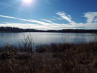
Last Mountain Lake, also known as Long Lake, is a prairie lake formed from glaciation 11,000 years ago. It is located in south central Saskatchewan, Canada, about 40 kilometres (25 mi) north-west of the city of Regina. It flows into the Qu'Appelle River via Last Mountain Creek, which flows past Craven. It is approximately 93 km (58 mi) long, and 3 km (1.9 mi) across at its widest point. It is the largest naturally occurring body of water in southern Saskatchewan. Only Lake Diefenbaker, which is man-made, is larger. The lake is a popular resort area for residents of south-eastern Saskatchewan.
Highway 20 is a north–south provincial highway in the southern part of the Canadian province of Saskatchewan. It runs from Highway 11 in the Qu'Appelle Valley at Lumsden north to Highway 3 near Birch Hills. Along its route, it provides access to several communities, lakes, and parks. The highway is about 291 kilometres (181 mi) long.

Highway 358 is a provincial highway in the Canadian province of Saskatchewan. It runs from Highway 18 near Wood Mountain to Highway 13 near Limerick. It is about 42.5 kilometres (26.4 mi) long.
Beaver Lake is a lake in the south-eastern portion of the Canadian province of Saskatchewan, just north of the community of Kenosee Lake in Moose Mountain Provincial Park.
Grandview Beach is a resort village in the Canadian province of Saskatchewan within Census Division No. 6. It is on the shores of Last Mountain Lake in the Rural Municipality of Sarnia No. 221.
Lumsden Beach is a resort village in the Canadian province of Saskatchewan, Canada, within Census Division No. 6. It is on the shores of Last Mountain Lake in the Rural Municipality of Lumsden No. 189.
Saskatchewan Beach is a resort village in the Canadian province of Saskatchewan within Census Division No. 6. It is on the eastern shore of Last Mountain Lake in the Rural Municipality of McKillop No. 220. Access is from Highway 322.

The Rural Municipality of Last Mountain Valley No. 250 is a rural municipality (RM) in the Canadian province of Saskatchewan within Census Division No. 11 and SARM Division No. 5.
Bulrush Lake may refer to:

Piapot First Nation is a Cree First Nation in southern Saskatchewan, Canada.
Last Mountain Creek is a river in south-central Saskatchewan. It is a tributary of the Qu'Appelle River in a region called the Prairie Pothole Region of North America, which extends throughout three Canadian provinces and five U.S. states. It is also within Palliser's Triangle and the Great Plains ecoregion.
Last Mountain Lake National Wildlife Area is a National Wildlife Area (NWA) in the Canadian province of Saskatchewan. The protected area is in the Prairie Pothole Region of North America, which extends throughout three Canadian provinces and five U.S. states. It is also within Palliser's Triangle and the Great Plains ecoregion. The site is an Important Bird Area (IBA) of Canada, designated as Last Mountain Lake NWA .
Rowan's Ravine Provincial Park is a provincial park in the Canadian province of Saskatchewan. It is on the eastern shore of Last Mountain Lake near a coulee named Rowan's Ravine in the RM of McKillop No. 220. Highway 220 provides access to the park and the town of Strasbourg is about 25 kilometres (16 mi) away. The hamlet of Uhl's Bay is less than a mile away just off of Highway 220.
Eyebrow Lake is a man-made marshy lake that parallels the Qu'Appelle River in the southern region of the Canadian province of Saskatchewan. Located in the RM of Huron No. 223, it is the first lake in a series of lakes along the Qu'Appelle River after Qu'Appelle River Dam and Lake Diefenbaker. The next lake downstream is Buffalo Pound Lake. The closest community is the village of Tugaske and, while there are no public recreation sites at the lake, it can be accessed by Highway 627. The lake gets its name from the nearby Eyebrow Hills, which are shaped like an eyebrow. The nearby town of Eyebrow and RM of Eyebrow No. 193 are also named after these hills.

