
Prince Albert National Park encompasses 3,874 square kilometres (1,496 sq mi) in central Saskatchewan, Canada and is about 200 kilometres (120 mi) north of Saskatoon. Though declared a national park March 24, 1927, official opening ceremonies weren't performed by Prime Minister William Lyon Mackenzie King until August 10, 1928. This park is open all year but the most visited period is from May to September. Although named for the city of Prince Albert, the park's main entrance is actually 80 kilometres (50 mi) north of that city via Highways 2 and 263, which enters the park at its southeast corner. Two additional secondary highways enter the park, Highway 264, which branches off Highway 2 just east of the Waskesiu townsite, and Highway 240, which enters the park from the south and links with 263 just outside the entry fee-collection gates. Prince Albert National Park is not located within any rural municipality, and is politically separate from the adjacent Northern Saskatchewan Administration District (NSAD). Until the establishment of Grasslands National Park in 1981, it was the province's only national park.

Lake Onega is a lake in northwestern Russia, on the territory of the Republic of Karelia, Leningrad Oblast and Vologda Oblast. It belongs to the basin of the Baltic Sea, and is the second-largest lake in Europe after Lake Ladoga, slightly smaller than Lebanon. The lake is fed by about 50 rivers and is drained by the Svir.

Jökulsárlón is a large glacial lake in southern part of Vatnajökull National Park, Iceland. Situated at the head of the Breiðamerkurjökull glacier, it developed into a lake after the glacier started receding from the edge of the Atlantic Ocean. The lake has grown since then at varying rates because of melting of the glaciers. The glacial front is now about 8 km (5.0 mi) away from the ocean's edge and the lake covers an area of about 18 km2 (6.9 sq mi). In 2009 it was reported to be the deepest lake in Iceland, at over 284 m (932 ft), as glacial retreat extended its boundaries. The size of the lake has increased fourfold since the 1970s.
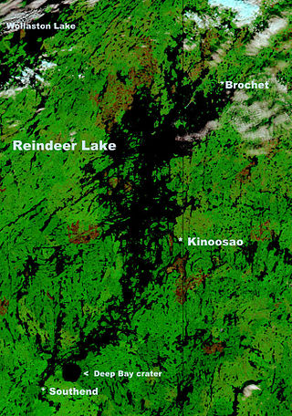
Reindeer Lake is a large lake in Western Canada located on the border between north-eastern Saskatchewan and north-western Manitoba, with the majority in Saskatchewan. The name of the lake appears to be a translation of the Algonquian name. It is the 24th largest lake in the world by area, as well as being the second-largest lake in Saskatchewan and the ninth largest in Canada. Eight percent of the lake lies in Manitoba while 92% of the lake is in Saskatchewan.
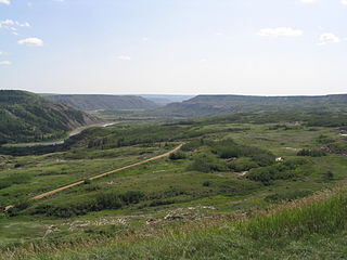
Dry Island Buffalo Jump Provincial Park is a provincial park in Central Alberta, Canada, located about 103 km (64 mi) southeast of Red Deer and 16 km (9.9 mi) northeast of Trochu, 1 mile north and 10 miles east of Huxley. The park is situated along the Red Deer River and features badlands topography. Its name derives from the large plateau in the middle of the park, 200 m (660 ft) above the Red Deer River, which has never been developed by humans and retains virgin prairie grasses.
Plenty is a village in the Canadian province of Saskatchewan within the Rural Municipality of Winslow No. 319 and Census Division No. 13. Plenty is located equidistant among Kindersley, Biggar, Kerrobert and Rosetown and approximately 150 kilometres southwest of the City of Saskatoon.

Cold Lake is a large lake in Northern Alberta and Saskatchewan, Canada. The lake straddles the Alberta / Saskatchewan border, and has a water area of 373 km2 (144 sq mi). It is also one of the deepest lakes in Alberta with a maximum depth of 200.1 m (656 ft). It has around 24 known species of fish and is a major ice fishing lake. Cold Lake is also major stop for many migrating birds, and is home to one of the largest warbler populations in Alberta. A surface of 248 km2 (96 sq mi) lies in the province of Alberta.
Highway 4 is a major highway in the Canadian province of Saskatchewan. It runs from U.S. Route 191 at the United States border near Monchy to Highway 224 / Highway 904 in Meadow Lake Provincial Park. Highway 4 is about 652 km (405 mi) long.
Highway 51 is a provincial highway in the Canadian province of Saskatchewan. It runs from the Alberta border near Compeer, Alberta, where it is preceded by Highway 12, to Highway 4 in Biggar, 1.1 kilometres (0.7 mi) south of Highway 14. Highway 51 is approximately 155 kilometres (96 mi) long. It passes through the town of Kerrobert, where it shares a 2.4 km (1.5 mi) concurrency with Highway 21 and Highway 31.
Highway 34 is a paved, undivided provincial highway in the Canadian province of Saskatchewan. It runs from Highway 13 about 16 kilometres (9.9 mi) west of Ogema south to the US border. The highway used to connect to Montana Secondary Highway 511 at the Port of Big Beaver, however the port is now closed. Highway 34 is in the south-central part of Saskatchewan and travels through a geographical area of rugged badlands, rolling hills, and open prairie. It is about 62 kilometres (39 mi) long.

Eagle Lake is a lake at 5,098 ft (1,554 m) elevation in Lassen County approximately 15 mi (24 km) north of Susanville, California. An endorheic alkaline lake, it is the second largest natural lake entirely in the state of California, United States.

Buffalo Pound Provincial Park is in southern Saskatchewan, Canada, about 30 kilometres (19 mi) north-east of Moose Jaw and 86 kilometres (53 mi) north-west of the city of Regina. Access to the provincial park is from Highways 301 and 202.

Totoket Mountain, with a high point of (est.) 720 ft (220 m) above sea level, is a traprock massif with several distinct summits, located 7 mi (11 km) northeast of New Haven, Connecticut. It is part of the Metacomet Ridge that extends from the Long Island Sound near New Haven, north through the Connecticut River Valley of Massachusetts to the Vermont border. Totoket Mountain is known for its 500 ft-high (150 m) scenic cliffs, microclimate ecosystems, rare plant communities, and for Lake Gaillard, a 2.5 mi-wide (4.0 km) public reservoir nearly enclosed by the mountain. The north ridge of Totoket Mountain is traversed by the 50 mi (80 km) Mattabesett Trail and a significant network of shorter trails. The name "Totoket Mountain" applies to both the entire mountain and to a subordinate northwestern peak.

Redberry Lake is a kettle salt lake near Hafford in the Canadian province of Saskatchewan. Named after the buffaloberry, it is a medium-sized saline lake within an area characterized by mostly fresh water aquatic environments. The lake makes up the core protected area of the Redberry Lake (UNESCO) Biosphere Reserve and is a federal bird sanctuary of the same name. It is also an Important Bird Area (IBA) of Canada and its northern most island is the location of the provincial Redberry Wildlife Refuge. A small regional park is situated at the north-west corner of the lake. The countryside surrounding Redberry Lake is typical of the aspen parkland biome of which it is a part.

Lake Sunapee is located within Sullivan County and Merrimack County in western New Hampshire, the United States. It is the fifth-largest lake located entirely in New Hampshire.
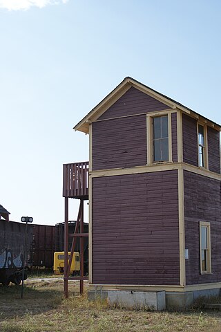
Oban is an unincorporated area administered by the rural municipality of Biggar No. 347, in the Canadian province of Saskatchewan. Oban is located on Saskatchewan Highway 14 in western Saskatchewan. The closest town is Biggar to the southeast. Biggar railway station is a divisional point for the Canadian National Railway (CNR). Oban had the last provincial interlocking tower at the Canadian National Railway and Canadian Pacific Railway level crossing, which was constructed in 1910 and closed in 1990.

The Rural Municipality of Biggar No. 347 is a rural municipality (RM) in the Canadian province of Saskatchewan within Census Division No. 12 and SARM Division No. 6.

Lake Ellery is a glacially-formed lake in South Westland on the West Coast of New Zealand's South Island. It has a steep and entirely forested catchment, with a diverse flora and fauna, and is accessible only by foot or boat. Sediments laid down by its tributaries have preserved a 2,000-year record of ruptures of the nearby Alpine fault.

Eagle Creek is a river in the Canadian province of Saskatchewan. The watershed of Eagle Creek is within the semi-arid Palliser's Triangle and is the major drainage system in mid-western Saskatchewan between the South and North Saskatchewan Rivers. Eagle Creek begins at the eastern end of Eaglehill Lake and travels through a glacier-cut valley in the moist, mixed grasslands ecozone of Canada en route to the North Saskatchewan River. The North Saskatchewan River merges with the South Saskatchewan River farther downstream to become the Saskatchewan River.


