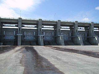
The Gardiner Dam on the South Saskatchewan River in Saskatchewan is the third largest embankment dam in Canada and one of the largest embankment dams in the world. Construction on Gardiner Dam and the smaller Qu'Appelle River Dam was started in 1959 and completed in 1967, creating Lake Diefenbaker upstream and diverting a considerable portion of the South Saskatchewan's flow into the Qu'Appelle River. The dam rises 64 metres (209 feet) in height, is almost 5 km (3.1 mi) long and has a width of 1.5 km (0.93 mi) at its base with a volume of 65,000,000 cubic meters. The dam is owned and operated by the Saskatchewan Water Security Agency.

Lake Diefenbaker is a reservoir and bifurcation lake in southern part of the Canadian province of Saskatchewan. It was formed by the construction of Gardiner Dam and the Qu'Appelle River Dam across the South Saskatchewan and Qu'Appelle Rivers respectively. Construction began in 1959 and the lake was filled in 1967. The lake is 225 kilometres (140 mi) long with approximately 800 kilometres (500 mi) of shoreline. It has a maximum depth of 66 metres (217 ft), while the water levels regularly fluctuate 3–9 metres (9–27 feet) each year. The flow of the two rivers is now regulated with a considerable portion of the South Saskatchewan diverted into the Qu'Appelle. Prior to the dams' construction, high water levels in the South Saskatchewan would frequently cause dangerous ice conditions downstream in Saskatoon while the Qu'Appelle would frequently dry up in the summer months.

The Rural Municipality of Blucher No. 343 is a rural municipality (RM) in the Canadian province of Saskatchewan within Census Division No. 11 and SARM Division No. 5. It is located in the north-central portion of the province on the South Saskatchewan River.
Kipahigan Lake is a lake in western Manitoba, and eastern Saskatchewan, Canada, approximately 50 kilometres (31 mi) north of Flin Flon. The lake is in the Canadian Shield region of Canada. In Saskatchewan, the Kipahigan Sakahikan 222 Indian reserve is on the northern shores of Kipahigan Lake.
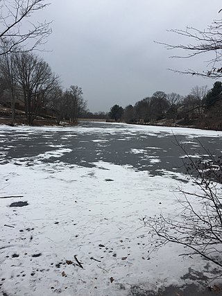
Lake Braddock is a reservoir in the community of Burke in Fairfax County, Virginia, United States. Lake Braddock is created by an impoundment on a tributary stream of Pohick Creek, itself a tributary of the Potomac River.

Avonlea is a village in the Canadian province of Saskatchewan within the RM of Elmsthorpe No. 100 and Census Division No. 2. The village is approximately 82 kilometres (51 mi) south-west of the city of Regina. The Southern Rails Cooperative maintains its head office in the village.

Bradwell is a village in the Canadian province of Saskatchewan within the Rural Municipality of Blucher No. 343 and Census Division No. 11. The village is located about 36 kilometres (22 mi) southeast of the city of Saskatoon on Highway 763. In 1936, during gravel excavations for a highway, the partial skeleton of a neolithic human male were discovered and named "Bradwell Man". A stone scraper and some eagle talons were found nearby.

The Rural Municipality of Coulee No. 136 is a rural municipality (RM) in the Canadian province of Saskatchewan within Census Division No. 7 and SARM Division No. 3. The RM is located in the southwest portion of the province, southeast of the City of Swift Current.

Brazeau Reservoir is a large man made reservoir in Alberta, Canada.
Ceylon is a village in the Canadian province of Saskatchewan within the Rural Municipality of The Gap No. 39 and Census Division No. 2. It is located alongside Gibson Creek, which is a tributary of Long Creek. No shops or businesses other than the bar remain.
Codette is a village in the Canadian province of Saskatchewan within the Rural Municipality of Nipawin No. 487 and Census Division No. 14. The village is located 10 km south of Nipawin at the junction of Highway 35 and Highway 789.
Braddock is an unincorporated community in Coulee Rural Municipality No. 136, Saskatchewan, Canada. The community is located on Highway 721, about 35 km (22 mi) southeast of Swift Current.
The Little Bow River is a tributary of the Oldman River in southern Alberta, Canada. It is about 190 kilometres (120 mi) long. From its headwaters near High River, it flows south, then turns east and flows into Travers Reservoir. Afterwards, it flows southeast into the Oldman River near Picture Butte. The Little Bow is related to the Bow River as they both ultimately feed the South Saskatchewan River.

The Rural Municipality of Rudy No. 284 is a rural municipality (RM) in the Canadian province of Saskatchewan within Census Division No. 11 and SARM Division No. 5.
The Saskatchewan Water Security Agency is an arm's length organization responsible for the management of water resources to ensure safe drinking water sources and reliable water supplies for economic, environmental, and social benefits in Saskatchewan, Canada. The Agency is a Treasury Board Crown Corporation administered by a board of directors appointed by the provincial government. Water Security Agency is located in Moose Jaw, SK, Canada and is part of the Water, Sewage and Other Systems Industry. Water Security Agency has 320.5 full time equivalent employees across all of its locations.

Blackstrap Lake is a man-made reservoir in central Saskatchewan, Canada, south of Saskatoon in the Rural Municipality of Dundurn No. 314. The lake was created as a reservoir in 1967, as part of the Saskatoon South East Water Supply System. Blackstrap Lake has an area of 1,200 ha and is generally used to support irrigation, and the industrial and municipal water supply.
Lake of the Rivers is a salt lake in the Canadian province of Saskatchewan. It is in the Prairie Pothole Region of North America, which extends throughout three Canadian provinces and five U.S. states, and within Palliser's Triangle and the Great Plains ecoregion of Canada. The lake is long, narrow, shallow, and located in a valley that was formed by glacial meltwaters at the end of the ice age. The north end of the valley opens up to Old Wives Lake and south-east along the valley is Willow Bunch Lake. Beyond Willow Bunch Lake, the valley opens up into the Big Muddy Badlands.
Wood River is a river in the Canadian province of Saskatchewan. It has its source in the Wood Mountain Hills of south-western Saskatchewan and flows in a north-easterly direction to its mouth at Old Wives Lake. Old Wives Lake is a salt water lake with no outflow. As a result, the drainage basin of Wood River is an endorheic one. Along the course of the river, there are several parks, historical sites, and small towns.

