Rasmussen Lowlands

Last updated
Rasmussen Lowlands
Coordinates 68°40′N93°0′W / 68.667°N 93.000°W / 68.667; -93.000 Coordinates: 68°40′N93°0′W / 68.667°N 93.000°W / 68.667; -93.000
Area3,000 square kilometres (1,200 sq mi)
Designated24 May 1982
Reference no.247 [1]

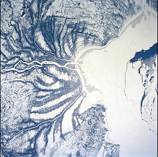
The Rasmussen Lowlands is a 3,000 km2 coastal plain complex of wetlands in Kitikmeot Region, Nunavut, Canada. It was designated a Ramsar wetland of international importance by the Ramsar Convention on May 24, 1982. [2] It is also classified as an Important Bird Area. [3]

A coastal plain is flat, low-lying land adjacent to a sea coast. One of the largest coastal plains is located in southeastern United States. The Gulf Coastal Plain of North America extends northwards from the Gulf of Mexico along the Lower Mississippi River to the Ohio River, which is a distance of about 981 miles (1,579 km).

Canada Country in North America

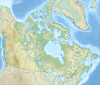
Canada is a country in the northern part of North America. Its ten provinces and three territories extend from the Atlantic to the Pacific and northward into the Arctic Ocean, covering 9.98 million square kilometres, making it the world's second-largest country by total area. Canada's southern border with the United States, stretching some 8,891 kilometres (5,525 mi), is the world's longest bi-national land border. Its capital is Ottawa, and its three largest metropolitan areas are Toronto, Montreal, and Vancouver. As a whole, Canada is sparsely populated, the majority of its land area being dominated by forest and tundra. Consequently, its population is highly urbanized, with over 80 percent of its inhabitants concentrated in large and medium-sized cities, with 70% of citizens residing within 100 kilometres (62 mi) of the southern border. Canada's climate varies widely across its vast area, ranging from arctic weather in the north, to hot summers in the southern regions, with four distinct seasons.

Ramsar Convention international treaty for the conservation and sustainable utilization of wetlands

The Ramsar Convention on Wetlands of International Importance especially as Waterfowl Habitat is an international treaty for the conservation and sustainable use of wetlands. It is also known as the Convention on Wetlands. It is named after the city of Ramsar in Iran, where the Convention was signed in 1971.

The poorly drained area consists of flat lowlands overlain by marine silts and sand, with numerous tundra ponds throughout. [4]

Drainage natural or artificial removal of surface and sub-surface water from an area

Drainage is the natural or artificial removal of a surface's water and sub-surface water from an area with excess of water. The internal drainage of most agricultural soils is good enough to prevent severe waterlogging, but many soils need artificial drainage to improve production or to manage water supplies.

Silt is granular material of a size between sand and clay, whose mineral origin is quartz and feldspar. Silt may occur as a soil or as sediment mixed in suspension with water and soil in a body of water such as a river. It may also exist as soil deposited at the bottom of a water body, like mudflows from landslides. Silt has a moderate specific area with a typically non-sticky, plastic feel. Silt usually has a floury feel when dry, and a slippery feel when wet. Silt can be visually observed with a hand lens, exhibiting a sparkly appearance. It also can be felt by the tongue as granular when placed on the front teeth.

Sand A granular material composed of finely divided rock and mineral particles, from 0.063 to 2 mm diameter

Sand is a granular material composed of finely divided rock and mineral particles. It is defined by size, being finer than gravel and coarser than silt. Sand can also refer to a textural class of soil or soil type; i.e., a soil containing more than 85 percent sand-sized particles by mass.

Shorebirds numbering up to 500,000 individuals [4] nest in the ponds and surrounding areas. The vulnerable peregrine falcon nests in the adjacent escarpment, with nearly 6% (80 pairs) of the national population observed here in 1995. [3]

Peregrine falcon A widespread bird of prey in the family Falconidae

The peregrine falcon, also known as the peregrine, and historically as the duck hawk in North America, is a widespread bird of prey (raptor) in the family Falconidae. A large, crow-sized falcon, it has a blue-grey back, barred white underparts, and a black head. It is believed to be the fastest bird in the world. According to a National Geographic TV programme, the highest measured speed of a peregrine falcon is 389 km/h (242 mph). As is typical of bird-eating raptors, peregrine falcons are sexually dimorphic, with females being considerably larger than males. The peregrine is renowned for its speed, reaching over 320 km/h (200 mph) during its characteristic hunting stoop, making it the fastest member of the animal kingdom.

Escarpment Steep slope or cliff separating two relatively level regions

An escarpment, or scarp, is a steep slope or long cliff that forms as an effect of faulting or erosion and separates two relatively level areas having differing elevations. Usually scarp and scarp face are used interchangeably with escarpment.

Related Research Articles

A Ramsar site is a wetland site designated to be of international importance under the Ramsar Convention.

Whooping Crane Summer Range is a 16,895 km² wetland complex in the boreal forests of northern Alberta and southwestern Northwest Territories in Canada. It is the only natural nesting habitat for the endangered whooping crane. On May 24, 1982 it was designated a Ramsar wetland of international importance, one of two such sites in Wood Buffalo National Park. It is owned by the Government of Canada, and is administered by Parks Canada with some input from Indian and Northern Affairs Canada. Encompassing the northeastern portion of Wood Buffalo National Park, approximately 2,300 km² (14%) of the wetland is external to the park, on Crown land in the Northwest Territories. It is also classified an Important Bird Area.

Matchedash Bay is a bay and Ramsar wetland in Simcoe County in Central Ontario, Canada. It is the "final inland extension of Severn Sound" on Lake Huron's Georgian Bay, and is "situated at the interface between the Saint Lawrence Lowlands and the Canadian Shield ". It exhibits geologically unique features at the junction of the Canadian Shield and southern Ontario limestone. Wetland habitats in Matchedash Bay are varied, and include swamps, fens, cattail marshes, wet meadows and beaver ponds. Other features include "permanent freshwater lakes; upland hardwood forest, agricultural lands, native grass meadows and a unique, coniferous wetland forest".

Southern James Bay

Southern James Bay is a coastal wetland complex in northeastern Ontario, Canada bordering James Bay and Quebec. It was designated as a wetland of international importance via the Ramsar Convention on May 27, 1987. The shallow waters of the James Bay region represent an important late autumn staging area for migratory, Arctic-breeding waterbirds.

Dewey Soper Migratory Bird Sanctuary

Dewey Soper Migratory Bird Sanctuary, or Dewey Soper, is a migratory bird sanctuary in the Qikiqtaaluk Region, Nunavut, Canada. It is located in western Baffin Island, from Bowman Bay to the Koukdjuak River, and is named in honour of zoologist J. Dewey Soper. It is an 8,159 km2 (3,150 sq mi) area that was classified a wetland of international importance via the Ramsar Convention on May 24, 1982. The bird sanctuary supports nearly 30% of the breeding geese in Canada, making it the largest goose colony in the world. Up to two million birds of various species use the area for summer nesting, and it is also "habitat for one of Canada's major barren-ground caribou herds". The sanctuary was established in 1957, and is subject to the Nunavut Land Claims Agreement, which defines and governs ownership, land use and hunting rights in the area.

Old Crow Flats is a 6,170 km2 (2,382 sq mi) wetland complex in northern Yukon, Canada along the Old Crow River. It is north of the Arctic Circle and south of the Beaufort Sea, and is nearly surrounded by mountains.

Polar Bear Pass

Polar Bear Pass is a 262,400 hectare wetland and mountain pass on Bathurst Island within the Qikiqtaaluk Region, Nunavut, Canada. The pass is on federal Crown land.

Quill Lakes group of lakes in Canada

The Quill Lakes is a wetland complex in Saskatchewan, Canada that encompasses the endorheic basin of three distinct lake wetlands: Big Quill Lake, Middle Quill Lake and Little Quill Lake. On May 27, 1987, it was designated a wetland of international importance via the Ramsar Convention. It was the first Canadian site in the North American Waterfowl Management Plan, is a site in the International Biological Programme and Saskatchewan Heritage Marsh Program, and was designated a Western Hemisphere Shorebird Reserve Network site of International significance in May, 1994. The site is an important staging and breeding area for spring and fall migration of shorebirds. The site qualifies as an Important Bird Area for its globally and nationally significant migratory and breeding populations of more than a dozen species of birds.

Baie de lIsle-Verte

Baie de l'Isle-Verte is a 22.2 square kilometres (8.6 sq mi) coastal wetland along the southern shore of the Saint Lawrence River in Quebec, Canada. It was designated a Ramsar wetland of international importance on May 27, 1987, is classified as a globally significant Important Bird Area, and contains a National Wildlife Area and Migratory Bird Sanctuary. It is located in the Rivière-du-Loup Regional County Municipality, in the municipality of L'Isle-Verte.

Shepody Bay is a tidal embayment, an extension of the Bay of Fundy in New Brunswick, Canada, which consists of 77 km² of open water and 40 km² of mudflats, with 4 km² of saline marsh on the west, and eroding sand and gravel beaches covering an area of approximately 1 km² on the eastern shore. The intertidal mudflats "support internationally important numbers of the crustacean Corophium volutator, the principal food source for millions of fall migrating shorebirds".

The Creston Valley Wildlife Management Area is a Canadian river delta wetland and Wildlife Management Area near Creston in south-central British Columbia, on the floodplain of the Kootenay River at the south end of Kootenay Lake. Predominantly marshland, it was classified as a wetland of international importance on February 21, 1994, and is also a globally significant Important Bird Area. It is one of the "few significant agricultural areas of the province", and is in the Montane Cordillera. It stretches north along Kootenay Lake for approximately 20 km, and south to the United States border. It is both the only breeding site of the Forster's tern and the only site with leopard frogs in the province, as well as one of the few Canadian habitats for the Coeur D'Alene salamander. Creston Valley provides staging and nesting areas for migratory birds on the Pacific Flyway.

The Tabusintac Lagoon and River Estuary is a wetland in Alnwick Parish, Northumberland County, in north-eastern New Brunswick, Canada. It was classified as a wetland of international importance on June 10, 1993. It is also a globally significant Important Bird Area for the population of common terns, and shorebirds in general, that it supports. Primarily a shallow coastal estuary with gentle slopes, the 50 km2 site is underlain by various sedimentary rocks, including red sandstone and shale. The lagoon system is protected from the Gulf of Saint Lawrence by a constantly shifting barrier beach and dune system that frequently blocks commonly used navigation channels. It attains an elevation of no more than 8 m above sea level.

Grand Codroy Estuary Estuary in Newfoundland and Labrador, Canada

The Grand Codroy Estuary is a 925 hectare wetland on the southwestern coast of the island of Newfoundland in Canada, approximately 30 km north of Port aux Basques. It is "[one] of the most productive of Newfoundland's few estuarine wetland sites", and is "the province's most important wetland". It is a Wetland of International Importance under the Ramsar Convention, receiving this designation on May 27, 1987. To the south is a globally significant Important Bird Area.

Hay-Zama Lakes group of lakes in Canada

Hay-Zama Lakes is a 586-square-kilometre (226 sq mi) inland wetland and wildland park in northwestern Alberta, Canada. It was designated a Ramsar wetland of international importance on May 24, 1982, and is recognized as an Important Bird Area. It "constitutes one of the most extensive sedge wetlands in western North America".

Queen Maud Gulf Migratory Bird Sanctuary migratory bird sanctuary in Nunavut, Canada

The Queen Maud Gulf Migratory Bird Sanctuary is Canada's largest federally owned protected area, encompassing some 61,765 km2 (23,848 sq mi) of the Arctic Circle coastline. 6,710 km2 (2,590 sq mi) are marine, and 55,055 km2 (21,257 sq mi) are terrestrial.

Flood Plain Lower Ringarooma River wetlands Protected area in Tasmania, Australia

The Flood Plain Lower Ringarooma River wetlands is a wetland site comprises the floodplain of the lower Ringarooma River in north-eastern Tasmania, Australia. In 1982 it was designated a wetland of international importance under the Ramsar Convention.

References

  1. "Rasmussen Lowlands". Ramsar Sites Information Service. Retrieved 25 April 2018.
  2. "Rasmussen Lowlands, Nunavut". Ramsar Sites. Environment Canada . Retrieved 2008-01-29.
  3. 1 2 "Rasmussen Lowlands". IBA Canada. Retrieved 2008-01-29.
  4. 1 2 "The Annotated Ramsar List: Canada". The Annotated Ramsar List of Wetlands of International Importance. Ramsar Convention Bureau. 2000-01-10. Archived from the original on 2007-12-30. Retrieved 2008-01-29.