Lochaber, Quebec

Last updated

Lochaber
Lochaber QC.jpg
Lochaber Quebec location diagram.png
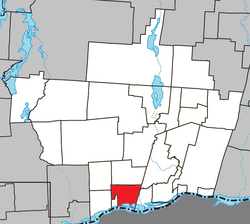
Location within Papineau RCM
Canada Western Quebec location map.png
Red pog.svg
Lochaber
Location in western Quebec
Coordinates: 45°38′N75°13′W / 45.633°N 75.217°W / 45.633; -75.217 [1]
Country Canada
Province Quebec
Region Outaouais
RCM Papineau
ConstitutedJuly 1, 1855
Government
[2]
  MayorGeorges Leduc
   Federal riding Argenteuil—La Petite-Nation
   Prov. riding Papineau
Area
  Total
70.00 km2 (27.03 sq mi)
  Land62.04 km2 (23.95 sq mi)
Population
 (2021)
  Total
446
  Density7.2/km2 (19/sq mi)
  Pop 2016-2021
Increase2.svg 7.5%
  Dwellings
194
Time zone UTC−5 (EST)
  Summer (DST) UTC−4 (EDT)
Postal code(s)
Area code 819
Highways
Quebec Autoroute 50.svg A-50

Qc148.svg R-148
Qc317.svg R-317

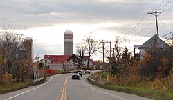
Lochaber is a township municipality in the Canadian province of Quebec, located within the Papineau Regional County Municipality. The township had a population of 415 in the 2016 Canadian Census.

Contents

History

In 1807, a group of Scots settled in the southern part of the Blanche River valley, the same year the geographic township of Lochaber Gore was created. They came from Thurso in Scotland, as well as from the Highlands, near Lochaber and other parts of northern Scotland. [4]

In 1845, the township municipality was formed but abolished in September 1847 when it became part of Ottawa County. In 1855, it was reestablished. [1]

In 1886, the village municipality of Thurso separated from the township, [4] and in 1891, the western half the township was split off to form the township municipality of Lochaber-Partie-Ouest. [5]

Demographics

Historical census populations – Lochaber, Quebec
YearPop.±%
1986 505    
1991 521+3.2%
1996 510−2.1%
2001 456−10.6%
2006 497+9.0%
2011 409−17.7%
2016 415+1.5%
Source: Statistics Canada

In the 2021 Census of Population conducted by Statistics Canada, Lochaber had a population of 446 living in 176 of its 194 total private dwellings, a change of 7.5% from its 2016 population of 415. With a land area of 62.14 km2 (23.99 sq mi), it had a population density of 7.2/km2 (18.6/sq mi) in 2021. [6]

Canada census – Lochaber community profile
2021 2016 2011
Population446 (+7.5% from 2016)415 (1.5% from 2011)409 (-17.7% from 2006)
Land area62.14 km2 (23.99 sq mi)60.70 km2 (23.44 sq mi)62.04 km2 (23.95 sq mi)
Population density7.2/km2 (19/sq mi)6.8/km2 (18/sq mi)6.6/km2 (17/sq mi)
Median age46.0 (M: 47.6, F: 43.2)42.0 (M: 44.8, F: 39.5)42.4 (M: 45.3, F: 38.5)
Private dwellings194 (total)  176 (occupied)183 (total) 167 (total) 
Median household income$75,500$58,880$32,110
References: 2021 [7] 2016 [8] 2011 [9]

Mother tongue: [3]

References

  1. 1 2 "Banque de noms de lieux du Québec: Reference number 36335". toponymie.gouv.qc.ca (in French). Commission de toponymie du Québec.
  2. 1 2 "Répertoire des municipalités: Geographic code 80055". www.mamh.gouv.qc.ca (in French). Ministère des Affaires municipales et de l'Habitation.
  3. 1 2 "Lochaber, Quebec (Code 2480055) Census Profile". 2016 census . Government of Canada - Statistics Canada.
  4. 1 2 "Thurso" (in French). Commission de toponymie du Québec. Retrieved 2020-01-20.
  5. "Lochaber-Partie-Ouest" (in French). Commission de toponymie du Québec. Retrieved 2020-01-20.
  6. "Population and dwelling counts: Canada, provinces and territories, and census subdivisions (municipalities), Quebec". Statistics Canada. February 9, 2022. Retrieved August 28, 2022.
  7. "2021 Community Profiles". 2021 Canadian census . Statistics Canada. February 4, 2022. Retrieved 2023-10-19.
  8. "2016 Community Profiles". 2016 Canadian census . Statistics Canada. August 12, 2021. Retrieved 2020-01-20.
  9. "2011 Community Profiles". 2011 Canadian census . Statistics Canada. March 21, 2019. Retrieved 2020-01-20.

Commons-logo.svg Media related to Lochaber, Quebec at Wikimedia Commons