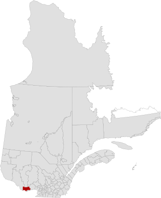
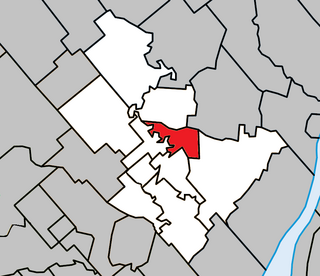
Notre-Dame-de-la-Paix, Quebec

Last updated
Notre-Dame-de-la-Paix
ND-de-la-Paix QC.JPG
Notre-Dame-de-la-Paix Quebec location diagram.png
Location within Papineau RCM
Canada Western Quebec location map.png
Red pog.svg
Notre-Dame-de-la-Paix
Location in western Quebec
Coordinates: 45°49′N74°58′W / 45.817°N 74.967°W / 45.817; -74.967 Coordinates: 45°49′N74°58′W / 45.817°N 74.967°W / 45.817; -74.967 [1]
Country Canada
Province Quebec
Region Outaouais
RCM Papineau
ConstitutedOctober 3, 1902
Government
[2]
  MayorFrançois Gauthier
   Federal riding Argenteuil—Papineau—Mirabel
   Prov. riding Papineau
Area
  Total107.50 km2 (41.51 sq mi)
  Land106.62 km2 (41.17 sq mi)
Population
 (2016) [3]
  Total648
  Density6.1/km2 (16/sq mi)
  Pop 2011-2016
Decrease2.svg 9.7%
  Dwellings
414
Time zone UTC−5 (EST)
  Summer (DST) UTC−4 (EDT)
Postal code(s)
Area code(s) 819
HighwaysQc323.svg Route 323
Website www.notredamedelapaix.qc.ca OOjs UI icon edit-ltr-progressive.svg

Notre-Dame-de-la-Paix (French for "Our Lady of Peace") is a town and municipality in the Outaouais region of Quebec, Canada, part of the Papineau Regional County Municipality.

Contents

History

In 1902, the municipality was formed out of sections of Notre-Dame-de-Bon-Secours and Saint-André-Avellin. Although it remains unclear what specific event is referred to in the name of this parish municipality, it followed the theme of municipal names in the Outaouais dedicated to the Virgin Mary, probably due to the Missionary Oblates of Mary Immaculate, who were missionaries and pastors throughout the region. [4]

In October 2003, the Parish Municipality of Notre-Dame-de-la-Paix changed statutes and became the Municipality of Notre-Dame-de-la-Paix. [4]

Demographics

Canada census – Notre-Dame-de-la-Paix community profile
2021 2016 2011
Population675 (+4.2% from 2016)648 (-9.7% from 2011)718 (-0.1% from 2006)
Land area105.96 km2 (40.91 sq mi)106.62 km2 (41.17 sq mi)105.62 km2 (40.78 sq mi)
Population density6.4/km2 (17/sq mi)6.1/km2 (16/sq mi)6.8/km2 (18/sq mi)
Median age50 (M: 49.6, F: 50.4)49.7 (M: 49.7, F: 49.7)48.3 (M: 48.8, F: 47.5)
Total private dwellings300414433
Median household income$43,264$29,935
References: 2021 [5] 2016 [6] 2011 [7] earlier [8] [9]
Historical census populations – Notre-Dame-de-la-Paix, Quebec
YearPop.±%
1986 693    
1991 662−4.5%
1996 688+3.9%
2001 689+0.1%
2006 719+4.4%
2011 718−0.1%
2016 648−9.7%
Source: Statistics Canada

Mother tongue: [3]

Education

Sir Wilfrid Laurier School Board operates Anglophone public schools:

Related Research Articles

Piedmont, Quebec Municipality in Quebec, Canada

Piedmont is a small municipality within the Les Pays-d'en-Haut Regional County Municipality, Quebec, Canada, in the Laurentian Mountains of the administrative region of Laurentides. It is located along the North River and Autoroute 15 and Route 117, north of Montreal.

Notre-Dame-de-la-Salette, Quebec Municipality in Quebec, Canada

Notre-Dame-de-la-Salette is a municipality in the Outaouais region of Quebec, Canada. It is part of the Papineau Regional County Municipality, straddling the eastern banks of the Du Lièvre River.

Gore, Quebec Township municipality in Quebec, Canada

Gore is a township municipality in the Canadian province of Quebec, located within the Argenteuil Regional County Municipality. Its main community is Lakefield.

Harrington, Quebec Township municipality in Quebec, Canada

Harrington is a township municipality in the Laurentides region of Quebec, Canada, part of the Argenteuil Regional County Municipality. It is located in the Laurentian Mountains, about 40 kilometres (25 mi) north-west of Lachute.

Wentworth, Quebec Township municipality in Quebec, Canada

Wentworth is a township municipality in the Laurentides region of Quebec, Canada, part of the Argenteuil Regional County Municipality, north-west of Lachute.

Notre-Dame-de-Bonsecours, Quebec Municipality in Quebec, Canada

Notre-Dame-de-Bonsecours is a municipality in the Outaouais region of Quebec, Canada. It is located along the Ottawa River, about 55 kilometres (34 mi) east of Gatineau. It was formerly known as Notre-Dame-de-Bon-Secours-Partie-Nord. It is the least populated municipality in the Papineau Regional County Municipality.

Val-des-Bois, Quebec Municipality in Quebec, Canada

Val-des-Bois is a town and municipality in the Papineau Regional County Municipality in the Outaouais region of Quebec, Canada. The town is located on the eastern shores of the Du Lièvre River, 47 kilometers (29 mi) north of Buckingham.

Montpellier, Quebec Municipality in Quebec, Canada

Montpellier is a town and municipality in the Papineau Regional County Municipality in the Outaouais region of Quebec, Canada. The town is located 30 kilometres (19 mi) northwest of Papineauville.

Montcalm, Quebec Municipality in Quebec, Canada

Montcalm is a municipality in the Les Laurentides Regional County Municipality of Quebec southeast of Mont-Tremblant. The main population centre in Montcalm is the village of Weir.

Chénéville, Quebec Municipality in Quebec, Canada

Chénéville is a town and municipality in the Outaouais region of Quebec, Canada, part of the Papineau Regional County Municipality.

Namur, Quebec Municipality in Quebec, Canada

Namur is a town and municipality in the Outaouais region of Quebec, Canada, part of the Papineau Regional County Municipality. It is nicknamed "la Nouvelle Belgique".

Boileau, Quebec Municipality in Quebec, Canada

Boileau is a village and municipality in the Outaouais region of Quebec, Canada, part of the Papineau Regional County Municipality. The municipality was known as Ponsonby until 1993.

Saint-André-dArgenteuil Municipality in Quebec, Canada

Saint-André-d'Argenteuil is a municipality in the Laurentides region of Quebec, Canada, part of the Argenteuil Regional County Municipality. It is located along the Ottawa River, just south of Lachute.

Mille-Isles Municipality in Quebec, Canada

Mille-Isles is a municipality in the Laurentides region of Quebec, Canada, part of the Argenteuil Regional County Municipality, west of Saint-Jérôme.

Lac-des-Seize-Îles Municipality in Quebec, Canada

Lac-des-Seize-Îles is a village and municipality in the Laurentides region of Quebec, Canada, part of the Les Pays-d'en-Haut Regional County Municipality. The municipality surrounds and is named after Sixteen Island Lake with the village situated at the northern end of this lake.

La Macaza Municipality in Quebec, Canada

La Macaza is a municipality and village in the province of Quebec, Canada. The village is located in the Laurentian Mountains, in the Laurentian region, in Antoine-Labelle Regional County Municipality. Its population was 1094 in the 2021 Canadian census.

Saint-Ambroise-de-Kildare, Quebec Municipality in Quebec, Canada

Saint-Ambroise-de-Kildare is a municipality in the Lanaudière region of Quebec, Canada, part of the Joliette Regional County Municipality.

Notre-Dame-de-Lourdes, Lanaudière, Quebec Municipality in Quebec, Canada

Notre-Dame-de-Lourdes is a municipality in the Lanaudière region of Quebec, Canada, part of the Joliette Regional County Municipality. It is located along the eastern shores of the L'Assomption River.

Entrelacs, Quebec Municipality in Quebec, Canada

Entrelacs is a municipality in Matawinie Regional County Municipality in the Lanaudière region of Quebec, Canada.

Notre-Dame-de-la-Merci Municipality in Quebec, Canada

Notre-Dame-de-la-Merci is a municipality in the Lanaudière region of Quebec, Canada, part of the Matawinie Regional County Municipality.

References

  1. "Reference number 378442 in Banque de noms de lieux du Québec". toponymie.gouv.qc.ca (in French). Commission de toponymie du Québec.
  2. 1 2 "Geographic code 80020 in the official Répertoire des municipalités". www.mamh.gouv.qc.ca (in French). Ministère des Affaires municipales et de l'Habitation.
  3. 1 2 3 "(Code 2480020) Census Profile". 2016 census . Statistics Canada. 2017.
  4. 1 2 "Notre-Dame-de-la-Paix (Municipalité de paroisse)" (in French). Commission de toponymie du Québec. Retrieved 2009-01-09.
  5. "2021 Community Profiles". 2021 Canadian Census . Statistics Canada. February 4, 2022. Retrieved 2022-04-27.
  6. "2016 Community Profiles". 2016 Canadian Census . Statistics Canada. August 12, 2021. Retrieved 2020-01-30.
  7. "2011 Community Profiles". 2011 Canadian Census . Statistics Canada. March 21, 2019. Retrieved 2020-01-30.
  8. "2006 Community Profiles". 2006 Canadian Census . Statistics Canada. August 20, 2019.
  9. "2001 Community Profiles". 2001 Canadian Census . Statistics Canada. July 18, 2021.
  10. "LAURENTIAN REGIONAL HS ZONE." Sir Wilfrid Laurier School Board. Retrieved on September 4, 2017.