Saint-Bruno-de-Montarville

Last updated

Saint-Bruno-de-Montarville
Centre-ville de Saint-Bruno-de-Montarville 2021.jpg
Downtown Saint-Bruno-de-Montarville
Blason ville ca Saint-Bruno-de-Montarville.svg
Motto(s): 
Fiers de nos traditions
(French for "Proud of our traditions")
Saint-Bruno-de-Montarville Quebec location diagram.PNG
Location within the urban agglomeration of Longueuil
Canada Southern Quebec location map.png
Red pog.svg
St-Bruno-de-Montarville
Location in southern Quebec
Coordinates: 45°32′N73°21′W / 45.533°N 73.350°W / 45.533; -73.350 [1]
CountryFlag of Canada (Pantone).svg  Canada
Province Flag of Quebec.svg  Quebec
Region Montérégie
RCM None
Agglomeration Longueuil
Founded1842
Constituted1 January 2006
Government
  MayorLudovic Grisé Farand
   MP Stéphane Bergeron (BQ)
   MNA Nathalie Roy (CAQ)
Area
  Total43.30 km2 (16.72 sq mi)
  Land43.28 km2 (16.71 sq mi)
Population
 (2011) [4]
  Total26,107
  Density603.3/km2 (1,563/sq mi)
  Dwellings
10,166
Demonym(s) Montarvillois,(e) (French)
Time zone UTC−5 (EST)
  Summer (DST) UTC−4 (EDT)
Area code(s) 450 and 579
Highways
Quebec Autoroute 30.svg A-30

Qc116.svg R-116
Website www.stbruno.ca

Saint-Bruno-de-Montarville is an off-island suburb of Montreal, in southwestern Quebec, Canada, on the south bank of the Saint Lawrence River just east of Montreal. It lies on the west flank of Mont Saint-Bruno, one of the Monteregian Hills. The population as of the Canada 2011 Census was 26,107. [4] It merged with Longueuil in 2002 but de-merged in 2006.

Contents

The city is well known to Montrealers and its neighbouring population for Mont Saint-Bruno, location to both Mont-Saint-Bruno National Park and Ski Mont Saint-Bruno, a ski facility and school.

Etymology

There are two prevailing hypotheses on the origin of the city's name:

History

The seigneury of Montarville

The old mill at Mont-Saint-Bruno National Park Le Vieux-Moulin.jpg
The old mill at Mont-Saint-Bruno National Park

Pierre Boucher de Boucherville Junior was granted the Montarville seigneury in 1710 by the governor of New France Philippe de Rigaud de Vaudreuil. In 1723, it was noted that clearing had not begun and no one was inhabiting the seigneury yet. [1]

The ownership remained in the Boucher family until 1829, when René Boucher de la Bruère sold half his land and his rights as a seigneur to François-Pierre Bruneau of Montréal. He died in 1851 and his brother Oliver-Théophile Bruneau (who was the first professor of anatomy at McGill University), was the last seigneur of Montarville from 1851 until the seigneural system was abolished in 1854. [6]

While agriculture was the primary subsistence and economical activity of the region, the seigneury of Montarville, thanks to its proximity to Mount Saint-Bruno, benefited much from the industrial activity that developed around the hydraulic power it could harvest from the mountain's many ponds and streams. The first water mill was erected in 1725 and in the 19th century, they numbered six in the territory and permitted such activities as grinding grain, milling wood, tanning leather and carding and spinning wool. [7]

The 19th century also saw the diversification of the seigneury's agricultural activities through increased animal husbandry, orchards, and maple syrup collection. [7]

From parish to village to city

Aerial view of Saint-Bruno in 1952 Saintbruno1952.jpg
Aerial view of Saint-Bruno in 1952

At the beginning of the 19th century, families residing on the western flank of the mountain were under the clerical responsibility of the parish of Boucherville while families from the southern flank were under the responsibility of the parish of Saint-Joseph de Chambly. As a consequence, the tithe was being paid to two different parishes, so in 1809 a first request to transform the seigneury into a parish was made to Mgr Joseph-Octave Plessis, Archbishop of Quebec. This request was met with a refusal. It would be thirty-three years before the Montarvillans attempted to form into their own parish again. [7]

It is worth mentioning that in 1838 during the Patriotes Rebellion, François-Pierre Bruneau's manor was occupied by the Patriotes and that one of them, André Proteau, was from the seigneury.

In 1842, a petition totaling about sixty signatures was presented to Mgr Ignace Bourget, Bishop of Montreal who agreed to the demand, and in the same year he signed a canonical decree officiating the creation of the parish of Saint-Bruno. François-Pierre Bruneau was honored with the choice of the titular saint, Saint Bruno.

In line with the Durham Report's recommendation to modernize municipal structures in 1840 (culminating in the abolition of the seigneury system in 1854) and the Acte pour abroger certaines ordonnances et pour faire de meilleures dispositions pour l'établissement d'autorités locales et municipales dans le Bas-Canada (Act to abrogate certain ordinances and to make better dispositions to establish local and municipal authorities in Lower-Canada), on 1 July 1845 the Legislative Assembly created more than 325 municipal corporations in eastern Canada of which Saint-Bruno, then with a population of 800, was a part. The following year on 9 October 1846, the parish municipality of Saint-Bruno was born through an official proclamation.

Downtown in 2021 Centre-ville de Saint-Bruno-de-Montarville 2021.jpg
Downtown in 2021

For a few years, Saint-Bruno remained part of the municipality of Chambly but in 1855, as mandated by the Loi constituant en municipalités toutes paroisses de plus de 300 personnes (Law making into a municipality every parish of more than 300 persons), the parish municipality became fully autonomous and its two names, "Saint-Bruno" and "Montarville", were joined into the designation still used to this day. [6]

It incorporated as a city in 1958.[ citation needed ]

Merger and demerger

In 2000, the Parti Québécois governments of Lucien Bouchard and Bernard Landry introduced a series of legislative measures with the intent of reorganizing and merging many of Quebec's municipalities. In 2002, following the adoption of bill 170, Saint-Bruno merged with other municipalities on Montreal's south shore to form the city of Longueuil. Following public outcry and a referendum, the city demerged from Longueuil and was reconstituted on 1 January 2006, but remained within the agglomeration of Longueuil, which remains responsible for a series of services to the population. [8] [9]

Demographics

Historical populations
YearPop.±%
18511,164    
18611,719+47.7%
18711,406−18.2%
1881894−36.4%
1891721−19.4%
1901872+20.9%
1911855−1.9%
1921927+8.4%
19311,024+10.5%
19411,262+23.2%
19511,816+43.9%
19616,760+272.2%
197115,780+133.4%
198122,880+45.0%
199123,849+4.2%
1996 23,714−0.6%
2001 23,843+0.5%
2006 24,388+2.3%
2011 26,107+7.0%
[10] [11] [12]

In the 2021 Census of Population conducted by Statistics Canada, Saint-Bruno-de-Montarville had a population of 26,273 living in 10,446 of its 10,629 total private dwellings, a change of

Language

The 2006 census found that about 85% of residents spoke French as a mother tongue (including persons who had more than one mother tongue), and that about 11% of residents spoke English as a mother tongue (also including persons who had more than one mother tongue). The next most common mother tongue was Italian. [14]

Mother tongue language (2006) [15]

Native languagePopulationPct (%)
French 20,34084.17%
English 2,44010.10%
Both English and French2350.97%
French and a non-official language650.27%
English and a non-official language100.04%
English, French and a non-official language100.04%
Italian 1400.58%
Arabic 1150.48%
German 1050.43%
Spanish 1050.43%
Portuguese 1000.41%
Chinese 800.33%
Polish 750.31%
Hungarian 450.19%
Dutch 350.14%
Czech 250.10%
Khmer 250.10%
Russian 250.10%

Transportation

Saint-Bruno-de-Montarville is served by the Saint-Bruno commuter rail station on the Réseau de transport métropolitain's Mont-Saint-Hilaire line. Local bus service is provided by the Réseau de transport de Longueuil.

Education

The South Shore Protestant Regional School Board previously served the municipality. [16] The French language school board Commission Scolaire des Patriotes oversees 3 primary education schools (École Albert-Schweitzer, École De Montarville and École Monseigneur-Gilles-Gervais) and one secondary education school (École Secondaire du Mont-Bruno). The English language school board Riverside School Board oversees primary schools Mount Bruno School and Courtland Park International.

Mont Saint-Bruno

The town resides at the foot of Mont Saint-Bruno, one of the mountains that make up the Monteregian Hills. The mountain is home to a provincial park, Parc National du Mont-Saint-Bruno , as well as a ski hill, Ski Mont Saint-Bruno.

Notable people

The following are notable residents or past residents of Saint-Bruno:

List of former mayors

See also

Related Research Articles

<span class="mw-page-title-main">Longueuil</span> City in Quebec, Canada

Longueuil is a city in the province of Quebec, Canada. It is the seat of the Montérégie administrative region and the central city of the urban agglomeration of Longueuil. It sits on the south shore of the Saint Lawrence River directly across from Montreal. The population as of the Canada 2016 Census totalled 239,700, making it Montreal's second largest suburb, the fifth most populous city in Quebec and twentieth largest in Canada.

<span class="mw-page-title-main">Boucherville</span> City in Quebec, Canada

Boucherville is a city in the Montérégie region in Quebec, Canada. It is a suburb of Montreal on the South shore of the Saint Lawrence River.

<span class="mw-page-title-main">Greenfield Park, Quebec</span> Borough of Longueuil in Quebec, Canada

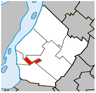
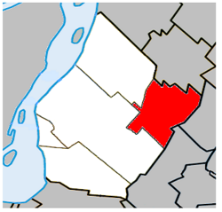
Greenfield Park is a former city in southwestern Quebec, Canada. It is currently a borough of the city of Longueuil. It covers an area of 4.78 square kilometres (1.85 sq mi), with a population of 16,733 at the 2016 census of Canada. Greenfield Park is the only borough of Longueuil that has an officially bilingual status. It is primarily a post-WWI suburban area. Like the other two boroughs, most of the buildings in Greenfield Park are single-family homes. Nearly all of the land in Greenfield Park is built on, making it Longueuil's most densely populated borough.

<span class="mw-page-title-main">Sainte-Julie, Quebec</span> City in Quebec, Canada

Sainte-Julie, is an off-island suburb of Montreal, in southwestern Quebec, Canada, east of Montreal in Marguerite-D'Youville Regional County Municipality. The population as of the Canada 2021 Census was 30,045. In 2009 Sainte-Julie was called one of the best towns in which to live in Quebec, and the city is often known as "The Happiest City in Quebec".

<span class="mw-page-title-main">Beloeil, Quebec</span> City in Quebec, Canada

Beloeil is a city in Quebec, Canada. It is a suburb of Montreal, on the South Shore and is on the Richelieu River, 32 kilometres (20 mi) east of Montreal. According to the official Commission de toponymie du Québec, the name is written Belœil with an oe ligature; however, other sources avoid the ligature, including the Ministry of Municipal Affairs and the town's own official website.

<span class="mw-page-title-main">Montérégie</span> Administrative region in Quebec, Canada

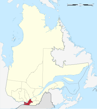
Montérégie is an administrative region in the southwest part of Quebec. It includes the cities of Boucherville, Brossard, Châteauguay, Longueuil, Saint-Hyacinthe, Saint-Jean-sur-Richelieu, Salaberry-de-Valleyfield and Vaudreuil-Dorion.

The 2000–2006 municipal reorganization in Quebec resulted in large-scale amalgamation of smaller municipalities in Quebec into larger cities. It was undertaken by one administration, and modified and partially undone by its successor.

<span class="mw-page-title-main">Chambly—Borduas</span> Former federal electoral district in the province of Quebec, Canada

Chambly—Borduas was a federal electoral district in the province of Quebec, Canada, that was represented in the House of Commons of Canada from 1867 to 1935, and from 1968 to 2015. Created by the British North America Act of 1867, its name was changed in 1893 to "Chambly—Verchères". In 1933, it was amalgamated into the Chambly—Rouville and Richelieu—Verchères electoral districts. The district was re-created in 1966 from Chambly—Rouville, Châteauguay—Huntingdon—Laprairie, and Richelieu—Verchères. Its name was changed in 2003 to "Chambly—Borduas". In 2015, most of the district became part of Beloeil—Chambly, while small parts of it joined Montarville and Pierre-Boucher—Les Patriotes—Verchères.

<span class="mw-page-title-main">Verchères—Les Patriotes</span> Federal electoral district in Quebec, Canada

Verchères—Les Patriotes was a federal electoral district in Quebec, Canada, that was represented in the House of Commons of Canada from 1979 until the 2012 electoral redistribution.

<span class="mw-page-title-main">Réseau de transport de Longueuil</span> Public transit system in Longueuil, Quebec

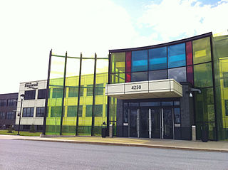
Réseau de transport de Longueuil (RTL) is a public transit system in the city of Longueuil, Quebec, Canada, and nearby communities on the South Shore of Montreal. The RTL had an annual ridership of 34,447,686 in 2013.

Claude Gladu is the former mayor of the city of Longueuil, Quebec. He served as mayor from 1994 to 2001 and from 2005 to 2009.

<span class="mw-page-title-main">South Shore (Montreal)</span> Place in Quebec, Canada

The South Shore is the general term for the suburbs of Montreal, Quebec located on the southern shore of the Saint Lawrence River opposite the Island of Montreal. The South Shore is located within the Quebec administrative region of Montérégie.

François-Pierre Bruneau was a lawyer, seigneur, businessman and political figure in Canada East.

An agglomeration, or urban agglomeration, is an administrative division of Quebec at the local level that may group together a number of municipalities which were abolished as independent entities on 1 January 2002 but reconstituted on 1 January 2006.

<span class="mw-page-title-main">Urban agglomeration of Longueuil</span> Urban agglomeration in Quebec, Canada

The urban agglomeration of Longueuil was created on January 1, 2006 as a result of the de-amalgamation process brought upon by the Charest government. It encompasses all the boroughs that were merged into the previous city of Longueuil and still retains the same area as that mega-city.

Tancrède Boucher de Grosbois was a physician and political figure in Quebec. He represented Shefford in the Legislative Assembly of Quebec from 1888 to 1892 and from 1897 to 1903 as a Liberal.

<span class="mw-page-title-main">Mont-Saint-Bruno National Park</span>

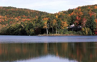
Mont-Saint-Bruno Provincial Park is a small national park of Quebec located near the municipality of Saint-Bruno-de-Montarville, 15 kilometres (9.3 mi) to the east of Montréal on the south shore of the Saint Lawrence River. The park, with an area of 8.84 square kilometres (3.41 sq mi), notably includes Mont Saint-Bruno, one of the Monteregian Hills which peaks at 218 metres (715 ft). The mountain is shared with the Ski Mont Saint-Bruno ski resort, a quarry and a small Canadian Forces training camp. Despite its relatively small size, the mountain is known for its rich fauna and flora. Situated at the heart of the old signory of Montarville, its many lakes have permitted the construction and exploitation of many water mills, contributing to the region's economical success. A building from one of those mills, the "Vieux Moulin", still stands to this day and is used as a rest area for skiers and hikers in different seasons.

Champlain was a former regional county municipality and census division in the Canadian province of Quebec. It ceased to exist when it amalgamated into the expanded city of Longueuil on January 1, 2002.

References

  1. 1 2 3 Commission de toponymie du Québec. "Fiche descriptive — Saint-Bruno-de-Montarville". Government of Québec. Retrieved 23 December 2010.
  2. 1 2 Ministère des Affaires municipales, des Régions et de l'Occupation du territoire: Saint-Bruno-de-Montarville
  3. Parliament of Canada Federal Riding History: SAINT-BRUNO--SAINT-HUBERT (Quebec)
  4. 1 2 3 "Census Profile — Saint-Bruno-de-Montarville, Ville". Canada 2011 Census . Statistics Canada. 8 February 2012. Retrieved 9 February 2012.
  5. Alfred Dauzat et Ch. Rostaing, Dictionnaire étymologique des noms de lieux en France, Librairie Guénégaud 1978.
  6. 1 2 Ville de Saint-Bruno-de-Montarville. "Profil historique — Ville de Saint-Bruno-de-Montarville". Ville de Saint-Bruno-de-Montarville. Retrieved 20 January 2011.
  7. 1 2 3 Alain Dufour. "Un peu d'histoire — Parti Montarvillois". Parti Montarvillois. Archived from the original on 27 July 2011. Retrieved 20 January 2011.
  8. "Saint-Bruno-de-Montarville (municipalité de ville)". Mémoire du Québec. Retrieved 28 December 2011.
  9. "The Agglomération de Longueuil's legal framework". Agglomération de Longueuil. Retrieved 12 March 2015.
  10. Pratt, Michel. "Les paroisses au XIXe siècle". Société historique et culturelle du Marigot. Retrieved 24 October 2013.
  11. Pratt, Michel. "De la balkanisation des villes à leur fusion". Société historique et culturelle du Marigot. Retrieved 24 October 2013.
  12. Statistics Canada: 1996, 2001, 2006, 2011 census
  13. "Population and dwelling counts: Canada, provinces and territories, and census subdivisions (municipalities), Quebec". Statistics Canada. 9 February 2022. Retrieved 29 August 2022.
  14. "Saint-Bruno-de-Montarville, V". Detailed Mother Tongue (103), Knowledge of Official Languages (5), Age Groups (17A) and Sex (3) for the Population of Canada, Provinces, Territories, Census Divisions and Census Subdivisions, 2006 Census - 20% Sample Data. Statistics Canada. 20 November 2007. Retrieved 6 February 2008.
  15. 2006 Statistics Canada Community Profile: Saint-Bruno-de-Montarville, Quebec
  16. King, M.J. (Chairperson of the board). "South Shore Protestant Regional School Board" (St. Johns, PQ). The News and Eastern Townships Advocate . Volume 119, No. 5. Thursday 16 December 1965. p. 2. Retrieved from Google News on 23 November 2014.
  17. "La Montarvilloise Maryse Andraos gagne le Prix de la nouvelle Radio-Canada 2018". Les Versants de Mont-Bruno, April 17, 2018.
  18. "CIRQUE DU SOLEIL FINDS NEW STRATEGIC MAJORITY PARTNER IN TPG-LED INVESTOR GROUP". www.cirquedusoleil.com. Retrieved 23 November 2019.
  19. Constitution, By-laws, Regulations, History. Gloucester, Ontario: Canadian Amateur Hockey Association. May 1990. p. 112.