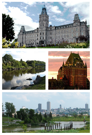
Quebec City, officially Québec, is the capital city of the Canadian province of Quebec. As of July 2021, the city had a population of 549,459, and the metropolitan area had a population of 839,311. It is the eleventh-largest city and the seventh-largest metropolitan area in Canada. It is also the second-largest city in the province, after Montreal. It has a humid continental climate with warm summers coupled with cold and snowy winters.

The Montmorency Falls is a large waterfall on the Montmorency River in Quebec, Canada.

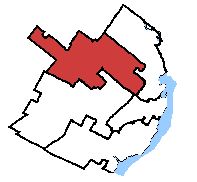
Louis-Hébert is a federal electoral district in the Canadian province of Quebec. Represented in the House of Commons since 1968, its population was certified, according to the detailed statistics of 2001, as 98,156.
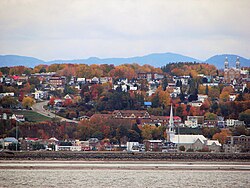
Charlesbourg is a borough of Quebec City, in the northeastern part of the city, west of the borough of Beauport.

Wendake is the current name for two urban reserves, Wendake 7 and Wendake 7A, of the Huron-Wendat Nation in the Canadian province of Quebec. They are enclaves entirely surrounded by the La Haute-Saint-Charles borough of Quebec City, within the former city of Loretteville. One of the Seven Nations of Canada, the settlement was formerly known as Village-des-Hurons, and also as (Jeune)-Lorette.
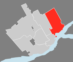
Beauport—Limoilou is a federal electoral district in Quebec City, Quebec, Canada, that has been represented in the House of Commons of Canada since 2004.
Charlesbourg—Haute-Saint-Charles is a federal electoral district in Quebec, Canada, that has been represented in the House of Commons of Canada since 1979.

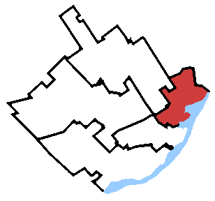
Beauport—Côte-de-Beaupré—Île d'Orléans—Charlevoix is a federal electoral district in Quebec, Canada, that has been represented in the House of Commons of Canada since 2004. An earlier Charlevoix—Montmorency riding was represented in the House of Commons from 1917 to 1925.

Bellechasse—Les Etchemins—Lévis is a federal electoral district in Quebec, Canada, that has been represented in the House of Commons of Canada since 2004. It was created in 2003 from Lévis-et-Chutes-de-la-Chaudière and Bellechasse—Etchemins—Montmagny—L'Islet ridings.
Montmorency was a federal electoral district in the province of Quebec, Canada, that was represented in the House of Commons of Canada from 1867 to 1917, and from 1968 to 2004.
The Battle of Beauport, also known as the Battle of Montmorency, fought on 31 July 1759, was an important confrontation between the British and French armed forces during the Seven Years' War of the French province of Canada. The attack conducted by the British against the French defense line of Beauport, some 5 kilometres (3.1 mi) east of Quebec was checked, and the British soldiers of General James Wolfe retreated with 443 casualties and losses.
Autoroute 440 is a superhighway located in Quebec City. It includes two separate segments, respectively named Autoroute Charest and Autoroute Dufferin-Montmorency. Originally meant to be connected and form a single continuous highway via a tunnel under the city centre, these plans were shelved years ago and are not expected to be revived.

Boischatel is a municipality in the Capitale-Nationale region of Quebec, Canada. The town was originally called Saint-Jean-de-Boischatel.

Jean-Lesage is a provincial electoral district in the Capitale-Nationale region of Quebec, Canada that elects members to the National Assembly of Quebec. It consists of parts of the Beauport and La Cité-Limoilou boroughs of Quebec City.
Montmorency is a provincial electoral district in the Capitale-Nationale region of Quebec, Canada. It comprises part of the Beauport borough of Quebec City and the municipality of Sainte-Brigitte-de-Laval.
Quebec County was a historic county in the province of Quebec, Canada. The county included the Quebec City metropolitan area and extended northwestward. The county seat was Loretteville.
La Cité-Limoilou is the central borough of Quebec City, the oldest, and the most populous, comprising 21.85% of the city's total population. As an administrative division, it is very new, having only been formed on November 1, 2009, from the former boroughs of La Cité and Limoilou.
Parc Montmorency is a park located in Quebec City and home to Parliaments of Lower Canada, Canada East and Quebec from 1791 to 1883. It is named for Henri II, Duke of Montmorency, the viceroy of New France, 1619–1625, under the French king, Louis XIII.

The Communauté urbaine de Québec was a regional municipal body that existed in the area around Quebec City from 1970 to 2001.