
Mount Royal is a large intrusive rock hill or small mountain in the city of Montreal, immediately west of Downtown Montreal, Quebec, Canada. The City of Montreal takes its name from Mount Royal.

Les Portes du Soleil is a major skisports destination in the Alps, encompassing thirteen resorts between Mont Blanc in France and Lake Geneva in Switzerland. With more than 650 km of marked pistes and about 200 lifts in total, spread over 14 valleys and about 1,036 square kilometres (400 sq mi), Portes du Soleil ranks among the two largest ski areas in the world. Almost all of the pistes are connected by lifts – a few marginal towns can be reached only by the free bus services in the area. The highest altitude accessible on skis is 2260m and the lowest is 930m. As with many other Alpine ski resorts, the lower slopes of the Portes du Soleil have snow-making facilities to extend the ski season by keeping the lower slopes open during the warmer months.
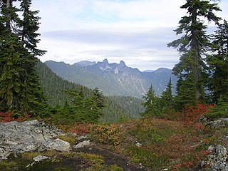
Cypress Provincial Park is a provincial park on the North Shore of Metro Vancouver Regional District, British Columbia. The park has two sections: a 21 km2 (8.1 sq mi) southern section which is accessible by road, and a 9 km2 (3.5 sq mi) northern section which is only accessible by hiking trails. Most of the park is in West Vancouver.

Les Houches is a commune in the Haute-Savoie department in the Auvergne-Rhône-Alpes region of Eastern France. In 2017, it had a population of 2,943.

ArgentièreFrench pronunciation: [aʁʒɑ̃tjɛʁ] is a picturesque skiing, alpine walking and mountaineering village in the French Alps, part of the commune of Chamonix Mont Blanc, at an altitude of 1,252 m (4,108 ft).

Cypress Mountain is a ski area in West Vancouver, British Columbia, Canada, located in the southern section of Cypress Provincial Park, operated under a BC Parks Park Use Permit.

Mad River Glen is a ski area in Fayston, Vermont. Located within the Green Mountain range, it sits in the Mad River Valley. Though not considered a large ski area, it has a vertical drop of 2,000 feet (610 m), which ranks 14th in New England, and its terrain was ranked by Ski magazine as the most challenging on the east coast of the United States.
Lift accessed mountain biking is a summer activity that is spreading all over the world. Using the chairlifts or gondola lifts at a ski area, mountain bikers can get up to higher altitudes quickly. The bikers don't have to ride up, and the ski area operators can keep the hill more profitable during the summer. Most bike parks have a mix of dirtjumping, downhill and freeride terrain on the trails.

Les Gets is a commune in the Haute-Savoie department in the Auvergne-Rhône-Alpes region in south-eastern France.

Mont Ripley is a ski hill located in Franklin Township, Houghton County, in Michigan's Upper Peninsula. The site is just outside the cities of Hancock and Houghton. It is owned by Michigan Technological University. It was founded in the early 1900s by Fred Pabst Jr.. With the addition of snow making in 2000, the season has been extended from late November to late March or early April.

E.C. Manning Provincial Park is a provincial park in British Columbia, Canada. It is usually referred to as Manning Park, although that nomenclature is also used to refer to the resort and ski area at the park's core. The park covers 83,671 hectares and was the second most visited provincial park in 2017-18 after Cypress Provincial Park. The park lies along British Columbia Highway 3, and occupies a large amount of land between Hope and Princeton along the Canada-United States border.

The Summit at Snoqualmie, is a winter resort in the northwest United States, located on Snoqualmie Pass, Washington. It provides alpine skiing and snowboarding, Nordic skiing, and winter tubing. Owned and managed by Boyne Resorts, it is 52 miles (80 km) east of downtown Seattle on Interstate 90.

Saddleback Maine is a ski resort located in Sandy River Plantation, near Rangeley, Maine, on the northwestern slopes of Saddleback Mountain. It is the third largest ski area in Maine, in terms of number of trails (66), number of lifts (3), snowmaking percentage (85%), vertical drop (2000 ft) and skier days. After almost 5 years of closed doors, Saddleback Mountain was sold to the Arctaris Impact Fund and reopened on December 15, 2020.

Mont Orignal is a ski mountain about 100 km south of Quebec City, Canada in the region of Bellechasse near the village of Lac-Etchemin.
The Massif du Sud is a ski mountain about 90 km southeast of Quebec City, Canada. It is part of the park of the same name, the Parc du Massif du Sud.

Crested Butte Mountain Resort is a ski resort located at Mount Crested Butte in Gunnison County, Colorado, United States.

Mont-Mégantic National Park(Parc national du Mont-Mégantic) is a national park in Quebec, Canada. It is located near the municipality of Notre-Dame-des-Bois in the Estrie region. The park was created in 1994 and is adjacent to the Samuel-Brisson Ecological Reserve which is located northeast of it.

Mont-Orford National Park is a national park in Orford, Quebec, Canada that is maintained and protected by the Sépaq. a provincial body.

Praz de Lys - Sommand is a twinned ski resort starting at a high altitude and composed of Sommand resort and Praz de Lys resort both linked by ski trails and chair lifts over and around their dividing mountains. Sommand sits high above its village of Mieussy and Praz de Lys sits above Taninges. The ski resort of Les Gets is also nearby Praz de Lys, about 15 minutes drive. It was opened in approximately 1978.