
Venedy is a village in Washington County, Illinois, United States. The population was 138 at the 2010 census.

Middletown is a census-designated place (CDP) in Bethlehem Township, Northampton County, Pennsylvania, United States. It is located in the Lehigh Valley region of the state.
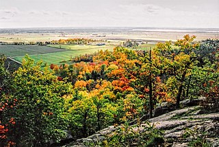
The Gatineau Hills are a geological formation in Canada that makes up part of the southern tip of the Canadian Shield, and acts as the northern shoulder of the Ottawa Valley. They are also the foothills of the Laurentian Mountains which stretch east through Quebec, beginning north of Montreal and joining up with others into Vermont and New Hampshire.

Celilo Village, Oregon is an unincorporated Native American community on the Columbia River in northeastern Wasco County in the U.S. state of Oregon. It is near Lake Celilo, the former site of Celilo Falls; it is just south of the community of Wishram, Washington, across the Columbia River.
Clucking Blossom is a free all-ages festival in Fairbanks, Alaska that combines art, activism, and music. Its Mission Statement reads: "Clucking Blossom is dedicated to bringing the community together to build new bridges of communication by facilitating an all-ages, grassroots festival of art, music, and ideas. Nothing will be bought or sold at this event. Clucking Blossom is designed and produced by a diverse ad hoc committee whose goal is to seriously rock, and furthermore to generate social awareness and build community in Fairbanks, Alaska." One of the original seeds that created the event was an effort to bring together the talent of bands from under 21 shows and combine them with bands and audiences of local bar venues in a way that featured music but also highlighted local and global issues with an effort to facilitate discussion. Clucking Blossom is a free all-ages event running from noon till midnight with many art inspired events and experiences that engage the viewer such as the interactive art-walk. Games, activities, and all things free are welcome. The festival is free because many volunteers donate their time and there are fundraisers around the year to add to a fund that pays for expenses such as security, port-a-potties, sound equipment rental and the fee to rent the venue.
Camp Fortune is a commercial alpine ski centre located in the municipality of Chelsea in the Gatineau Hills north of Gatineau, Quebec, approximately fifteen minutes from Downtown Ottawa, Ontario.
Santa Rosa de Lima is a municipality located in the Brazilian state of Sergipe. Its population was 3,740 in 2005, and its area is 68 km².

São Fidélis is a municipality located in the Brazilian state of Rio de Janeiro. Its population was 38,172 (2005) and its area is 1,028 km².

Rákoš is a village and municipality in Košice-okolie District in the Kosice Region of eastern Slovakia.
Ignaców is a village in the administrative district of Gmina Błędów, within Grójec County, Masovian Voivodeship, in east-central Poland.
Kresson Golf Course is a public 18-hole golf course founded in 1960 in the Kresson section of Voorhees Township, New Jersey. The course has a total length of 4,026 yards from the men's tees, with a par of 68.

Senchō Station is a railway station of Kyushu Railway Company located in Yatsushiro, Kumamoto, Japan.
KTXM is a terrestrial American radio station, airing a Country music format licensed to Hallettsville, Texas, simulcasting 94.3 KYKM Yoakum. The station is owned by Kremling Enterprises, Inc.
Big Cedar is an unincorporated community in Le Flore County, Oklahoma, in the United States. It is the Eastern end of the Ouachita National Forest Road.

Crossroads is an unincorporated community in Armstrong Township, Vanderburgh County, in the U.S. state of Indiana.
Hills Fork is a stream in Adams County, Ohio.
Mermill is an unincorporated community in Wood County, in the U.S. state of Ohio.


