Its territory, with a maximum elevation of just over 350 metres (1,150ft),[4] is sparsely populated, the majority of the population living along or near the Ottawa River. The northern portion is a vast extended tract of undeveloped land,[5] dotted with lakes, such as Findlay, Landon, Gagnon, and Caughlin, which are popular for fishing.[1]
History
The name Waltham, mentioned on the Gale and Duberger map of 1795, comes from a place on the River Lea in Essex, England, named Waltham Abbey. In 1849, the Waltham Township was formed.[4] In 1859, it was officially reorganized into a township municipality, also named Waltham,[1] and its first mayor was John T. Coghlan.[5]
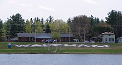
Winter view
In 1869, the Bryson Township was annexed, creating the United Township Municipality of Waltham-et-Bryson. The name Bryson comes from George Bryson Sr. (1813–1900), influential logging merchant, and mayor of Mansfield-et-Pontefract.[1] In 1888, the railroad from Fort-Coulonge to Waltham was completed but not until August 27, 1894, was the railroad opened by the Pontiac Pacific Junction Railway Company.[6] Four years later, in 1898, a post office was established, called Waltham Station.[1]
In 1937, a hydroelectric generating station and dam were built across the Noire River just north of Waltham village, forming a reservoir called Robinson Lake.[7]
In 1954, the Waltham Lumber Mill & Dry Kilns were built. It was designed by Brodie Gillies to run all year round producing hardwood lumber and commenced operation March 7, 1955. It produced 6 million board feet annually with 40 employees.[8]
In 1997, Waltham-et-Bryson was reorganized into the Municipality of Waltham.[1]
In 2007, the wood drying kilns at the town's lumberyard caught fire and closed.[citation needed] The property now serves as a storage site for a tree planting company.
On March 19, 1996, a UFO was reported to have landed in the town's lumberyard. "According to Hector Brochu, a witness of the event, he watched the object, which was described as a diamond shape, 2-1/2 feet high and 2 feet wide, fall to the ground like a feather. It made no noise whatsoever, and was very shiny, as if made of foil. There were no markings whatsoever. The object had what appeared to be a "bulb of mercury" hanging from it. When Brochu got within 10 feet of the object, which he was going to bring home for his daughter, the object rose into the air and remained in a fixed position approximately 150' in the air. Brochu, who ran when the object rose into the air, is 60 years old. The object had landed in a lumber yard. Brochu was able to get 8 people who all saw the object, which remained stationary for about 10 minutes and then left and landed again in what witnesses described as Alouette [sic] Island in the Ottawa River."[14][15]
In 2016, unexplained blue and red lights were reported in the sky near Waltham, hovering over the Waltham bridge for 20+ minutes.[16]
In 2021, the Waltham UFO Society was established.[17]
1 2 "Waltham". Répertoire des municipalités (in French). Ministère des Affaires municipales, des Régions et de l'Occupation du territoire. Archived from the original on 2012-10-17. Retrieved 2012-04-02.
This page is based on this Wikipedia article Text is available under the CC BY-SA 4.0 license; additional terms may apply. Images, videos and audio are available under their respective licenses.