Mansfield-et-Pontefract

Last updated

Mansfield-et-Pontefract
Mansfield-et-Pontefract QC.jpg
Mansfield-et-Pontefract Quebec location diagram.png
Location within Pontiac RCM
Canada Western Quebec location map.png
Red pog.svg
Mansfield-et-Pontefract
Location in western Quebec
Coordinates: 45°51′40″N76°44′21″W / 45.86111°N 76.73917°W / 45.86111; -76.73917 [1]
Country Canada
Province Quebec
Region Outaouais
RCM Pontiac
ConstitutedJanuary 1, 1868
Government
[2]
  MayorSandra Armstrong
   Federal riding Pontiac—Kitigan Zibi
   Prov. riding Pontiac
Area
  Total
523.45 km2 (202.11 sq mi)
  Land466.61 km2 (180.16 sq mi)
Population
 (2021) [3]
  Total
2,250
  Density4.8/km2 (12/sq mi)
  Pop (2016-21)
Decrease2.svg 1.5%
  Dwellings
1,074
Time zone UTC−5 (EST)
  Summer (DST) UTC−4 (EDT)
Postal code(s)
Area code 819
HighwaysQc148.svg R-148
Website www.mansfield-pontefract.com OOjs UI icon edit-ltr-progressive.svg
The chutes on the Coulonge River. Chutes-Coulonge 1024x584.JPG
The chutes on the Coulonge River.
The Bryson House, built in the 19th century and a Quebec historical site since 1980. Bryson House 1.JPG
The Bryson House, built in the 19th century and a Quebec historical site since 1980.

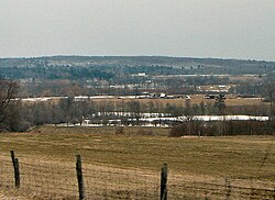
Mansfield-et-Pontefract is a municipality in the Pontiac Regional County Municipality of western Quebec, Canada. It is located on the Ottawa River, northwest of Gatineau. It is the most populated municipality in the Pontiac Regional County Municipality, with most of the population and businesses concentrated along Quebec Route 148. [4]

Contents

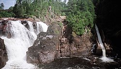
It is home to the main tourist attractions of the Pontiac region: the Chutes Coulonge, the George Bryson House, and the Félix-Gabriel-Marchand Bridge.

Communities

History

In 1849, the Mansfield Township was formed that was incorporated as a township municipality in 1855. It may have been named after the English town of Mansfield in Nottinghamshire or in honour of Sir James Mansfield (1733-1821), Solicitor General of Canada in 1780, or William Murray, 1st Earl of Mansfield (1705–1793). In 1863, Pontefract Township was officially established, named after an English town in Yorkshire. [1]

On January 1, 1868, the townships were merged to form the United Township Municipality of Mansfield-et-Pontefract. In 1888, a portion of its territory separated and was incorporated as the Village Municipality of Fort-Coulonge. In 2003, Mansfield-et-Pontefract changed its status from united township municipality to an ordinary municipality. [1]

Demographics

Population

Canada census – Mansfield-et-Pontefract community profile
2021 2016 2011
Population2,250 (-1.5% from 2016)2,285 (3.7% from 2011)2,204 (+6.2% from 2006)
Land area466.61 km2 (180.16 sq mi)477.44 km2 (184.34 sq mi)474.80 km2 (183.32 sq mi)
Population density4.8/km2 (12/sq mi)4.8/km2 (12/sq mi)4.6/km2 (12/sq mi)
Median age49.2 (M: 49.2, F: 49.2)47.1 (M: 47.1, F: 47.0)44.3 (M: 44.5, F: 44.2)
Private dwellings1,074 (total)  883 (occupied)1,113 (total) 1,030 (total) 
Median household income$76,500$61,664$.N/A
Notes: 2011 income data for this area has been suppressed for data quality or confidentiality reasons.
References: 2021 [5] 2016 [6] 2011 [7]

Language

Mother tongue (2021): [3]

See also

References

  1. 1 2 3 "Mansfield-et-Pontefract (Municipalité)" (in French). Commission de toponymie du Québec. Retrieved 2011-04-11.
  2. 1 2 "Mansfield-et-Pontefract". Ministère des Affaires municipales et de l'Habitation (in French). Retrieved 26 October 2022.
  3. 1 2 3 "Mansfield-et-Pontefract, Municipalité (MÉ) Census Profile, 2021 Census of Population". www12.statcan.gc.ca. Government of Canada - Statistics Canada. Retrieved 26 October 2022.
  4. Lisa Corrigan. "Municipality". Municipality of Mansfield-et-Pontefract. Retrieved 2011-04-12.
  5. "2021 Community Profiles". 2021 Canadian census . Statistics Canada. February 4, 2022. Retrieved 2023-10-19.
  6. "2016 Community Profiles". 2016 Canadian census . Statistics Canada. August 12, 2021. Retrieved 2019-11-22.
  7. "2011 Community Profiles". 2011 Canadian census . Statistics Canada. March 21, 2019. Retrieved 2014-01-28.
  8. 1996, 2001, 2006, 2011 census