Escuminac, Quebec

Last updated

Escuminac
Village de Pointe-a-la-Garde, comte Bonaventure - 1927.jpg
Village of Pointe-à-la-Garde in 1927
Escuminac Quebec location diagram.png
Location within Avignon RCM
Canada Eastern Quebec location map.png
Red pog.svg
Escuminac
Location in eastern Quebec
Coordinates: 48°07′N66°29′W / 48.12°N 66.48°W / 48.12; -66.48 [1]
Country Canada
Province Quebec
Region Gaspésie–
Îles-de-la-Madeleine
RCM Avignon
Settled2nd half of 18th century
ConstitutedOctober 10, 1907
Government
[2]
  MayorRobert Bruce Wafer
   Federal riding Gaspésie—
Îles-de-la-Madeleine
   Prov. riding Bonaventure
Area
  Total108.93 km2 (42.06 sq mi)
  Land108.70 km2 (41.97 sq mi)
Population
 (2021) [3]
  Total575
  Density5.3/km2 (14/sq mi)
  Pop (2016-21)
Increase2.svg 5.7%
  Dwellings
317
Time zone UTC−5 (EST)
  Summer (DST) UTC−4 (EDT)
Postal code(s)
Area code(s) 418 and 581
HighwaysQc132.svg R-132
Website www.escuminac.org OOjs UI icon edit-ltr-progressive.svg

Escuminac is a municipality in Quebec, Canada, on the north shore of the Restigouche River.

Contents

In addition to Escuminac itself, the municipality also includes the communities of Escuminac Flats, Fleurant, and Pointe-à-la-Garde.

According to missionary Joseph-Étienne Guinard, Escuminac is a Mi'kmaq word meaning "here are small fruits", originally identifying a point of land jutting into the Restigouche River. But this translation has been disputed as fanciful. It has been spelled in various ways over time, including Semenac, Scamanac, Scaumenac, Escouminac, Scoumenac, and Scouminac. [1]

History

Hotel and cabins in Pointe-a-la-Garde in 1948 Hotel et cabines de L.V. Cavanagh a Pointe-a-la-Garde - 1948.jpg
Hotel and cabins in Pointe-à-la-Garde in 1948

The area was first colonized by American Loyalist farmers and loggers. [1]

In 1845, the Municipality of Shoolbred, which included the area now known as Nouvelle, was first incorporated. It was named after John Shoolbred, who was the first owner of the seignory granted there. In 1847, the municipality was abolished but re-established in 1855. From 1861 on, it was known as the Township Municipality of Nouvelle-et-Shoolbred. [4]

In 1907, the township municipality was split into the Municipalities of Nouvelle-et-Shoolbred-Partie-Nord-Est (that became Nouvelle in 1953) and Nouvelle-et-Shoolbred-Partie-Sud-Ouest. This latter one was renamed to Escuminac in 1912. [1]

Demographics

Population

Canada census – Escuminac community profile
2021 2016 2011
Population575 (+5.7% from 2016)544 (-7.5% from 2011)588 (-8.8% from 2006)
Land area108.70 km2 (41.97 sq mi)108.20 km2 (41.78 sq mi)108.43 km2 (41.87 sq mi)
Population density5.3/km2 (14/sq mi)5.0/km2 (13/sq mi)5.4/km2 (14/sq mi)
Median age52.4 (M: 52.4, F: 52.4)49.0 (M: 47.3, F: 50.6)46.1 (M: 45.7, F: 46.6)
Private dwellings317 (total)  268 (occupied)297 (total)  241 (occupied)326 (total) 
Median household income$60,800$49,280$.N/A
Notes: 2011 income data for this area has been suppressed for data quality or confidentiality reasons.
References: 2021 [5] 2016 [6] 2011 [7] earlier [8] [9]
Historical Census Data - Escuminac, Quebec
YearPop.±%
1921 528    
1931 588+11.4%
1941 642+9.2%
1951 816+27.1%
1956 847+3.8%
1961 849+0.2%
YearPop.±%
1966 829−2.4%
1971 727−12.3%
1976 674−7.3%
1981 652−3.3%
1986 659+1.1%
1991 632−4.1%
YearPop.±%
1996 661+4.6%
2001 604−8.6%
2006 645+6.8%
2011 588−8.8%
2016 544−7.5%
2021 575+5.7%
Source: Statistics Canada [10]

Language

Mother tongue (2021): [3]

See also

Related Research Articles

<span class="mw-page-title-main">Pontiac, Quebec</span> Municipality in Quebec, Canada

Pontiac is a municipality in the Outaouais Region of western Quebec, Canada, on the north shore of the Ottawa River. It is part of Les Collines-de-l'Outaouais Regional County Municipality, included in the National Capital Region. It should not be confused with Pontiac Regional County Municipality, which is also in the Outaouais but not included in the National Capital Region.

<span class="mw-page-title-main">Nouvelle, Quebec</span> Municipality in Quebec, Canada

Nouvelle is a municipality in eastern Quebec, Canada, on the south shore of the Gaspé Peninsula at the mouth of the Nouvelle River, where the Restigouche River widens into Chaleur Bay.

<span class="mw-page-title-main">Mansfield-et-Pontefract</span> Municipality in Quebec, Canada

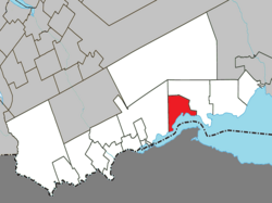
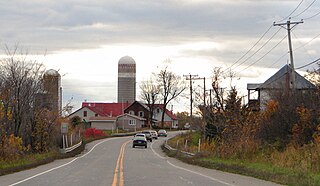
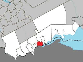
Mansfield-et-Pontefract is a municipality in the Pontiac Regional County Municipality of western Quebec, Canada. It is located on the Ottawa River, northwest of Gatineau. It is the most populated municipality in the Pontiac Regional County Municipality, with most of the population and businesses concentrated along Quebec Route 148.

<span class="mw-page-title-main">Pointe-à-la-Croix</span> Municipality in Quebec, Canada

Pointe-à-la-Croix is a municipality located on the Restigouche River in the Gaspésie region of eastern Quebec, Canada. It is situated across from the city of Campbellton, New Brunswick.

<span class="mw-page-title-main">Matapédia, Quebec</span> Municipality in Quebec, Canada

Matapédia is a municipality at the southern tip of the Gaspé Peninsula, in eastern Quebec, Canada. Matapédia is located along Quebec Route 132 on the border of New Brunswick.

<span class="mw-page-title-main">La Reine, Quebec</span> Municipality in Quebec, Canada

La Reine is a municipality in northwestern Quebec, Canada, on the La Reine River in the Abitibi-Ouest Regional County Municipality. It had a population of 340 in the Canada 2011 Census.

<span class="mw-page-title-main">Duhamel-Ouest</span> Municipality in Quebec, Canada

Duhamel-Ouest is a municipality in northwestern Quebec, Canada in the Témiscamingue Regional County Municipality.

<span class="mw-page-title-main">Senneterre, Quebec (parish)</span> Parish municipality in Quebec, Canada

Senneterre is a parish municipality in northwestern Quebec, Canada, in the La Vallée-de-l'Or Regional County Municipality. The parish is mostly a rural municipality that almost completely surrounds the actual population centre of the neighbouring City of Senneterre.

<span class="mw-page-title-main">L'Isle-aux-Allumettes</span> Municipality in Quebec, Canada

L'Isle-aux-Allumettes is a municipality in the Outaouais region, part of the Pontiac Regional County Municipality, Quebec, Canada. The municipality consists primarily of Allumette Island, and also includes Morrison Island, Marcotte Island, and some minor islets, all in the Ottawa River north of Pembroke.

<span class="mw-page-title-main">Lochaber, Quebec</span> Township municipality in Quebec, Canada

Lochaber is a township municipality in the Canadian province of Quebec, located within the Papineau Regional County Municipality. The township had a population of 415 in the 2016 Canadian Census.

<span class="mw-page-title-main">Lochaber-Partie-Ouest, Quebec</span> Township municipality in Quebec, Canada

Lochaber-Partie-Ouest is a township municipality in the Canadian province of Quebec, located within the Papineau Regional County Municipality. The township had a population of 926 in the 2021 Canadian Census.

<span class="mw-page-title-main">Chichester, Quebec</span> Township municipality in Quebec, Canada

Chichester is a township municipality and village in the Canadian province of Quebec, located within the Pontiac Regional County Municipality.

<span class="mw-page-title-main">Namur, Quebec</span> Municipality in Quebec, Canada

Namur is a town and municipality in the Outaouais region of Quebec, Canada, part of the Papineau Regional County Municipality. It is nicknamed "la Nouvelle Belgique".

<span class="mw-page-title-main">Sainte-Anne-du-Lac</span> Municipality in Quebec, Canada

Sainte-Anne-du-Lac is a municipality and village in the Laurentides region of Quebec, Canada, part of the Antoine-Labelle Regional County Municipality.

<span class="mw-page-title-main">Notre-Dame-du-Laus</span> Municipality in Quebec, Canada

Notre-Dame-du-Laus is a municipality in the Laurentides region of Quebec, Canada, part of the Antoine-Labelle Regional County Municipality.

<span class="mw-page-title-main">Saint-Aimé-du-Lac-des-Îles</span> Municipality in Quebec, Canada

Saint-Aimé-du-Lac-des-Îles is a municipality in the Laurentides region of Quebec, Canada, part of the Antoine-Labelle Regional County Municipality.

<span class="mw-page-title-main">Lac-des-Écorces, Quebec</span> Municipality in Quebec, Canada

Lac-des-Écorces is a municipality and village in the Laurentides region of Quebec, Canada, part of the Antoine-Labelle Regional County Municipality.

<span class="mw-page-title-main">Ristigouche-Sud-Est</span> Municipality in Quebec, Canada

Ristigouche-Sud-Est is a municipality in Quebec, Canada near the head of the Baie de Chaleur. It is a rural municipality without population centres, situated along the CN Railway line which hosts the VIA Rail Ocean (train) route; the nearest VIA station is Matapedia.

<span class="mw-page-title-main">Saint-André-de-Restigouche</span> Municipality in Quebec, Canada

Saint-André-de-Restigouche is a municipality in Quebec, Canada.

<span class="mw-page-title-main">Rivière-Nouvelle, Quebec</span> Unorganized territory in Quebec, Canada

Rivière-Nouvelle is an unorganized territory in the Gaspésie–Îles-de-la-Madeleine region of Quebec, Canada.

References

  1. 1 2 3 4 "Escuminac (Municipalité)" (in French). Commission de toponymie du Québec. Retrieved 2012-01-04.
  2. 1 2 "Répertoire des municipalités: Geographic code 06025". www.mamh.gouv.qc.ca (in French). Ministère des Affaires municipales et de l'Habitation. Retrieved 2024-04-10.
  3. 1 2 3 "Escuminac, Quebec (Code 2406025) Census Profile". 2021 census . Government of Canada - Statistics Canada . Retrieved 2024-04-10.
  4. "Nouvelle (Municipalité)" (in French). Commission de toponymie du Québec. Retrieved 2012-01-04.
  5. "2021 Community Profiles". 2021 Canadian Census . Statistics Canada. February 4, 2022. Retrieved 2023-10-19.
  6. "2016 Community Profiles". 2016 Canadian Census . Statistics Canada. August 12, 2021. Retrieved 2024-04-10.
  7. "2011 Community Profiles". 2011 Canadian Census . Statistics Canada. March 21, 2019. Retrieved 2014-02-06.
  8. "2006 Community Profiles". 2006 Canadian Census . Statistics Canada. August 20, 2019.
  9. "2001 Community Profiles". 2001 Canadian Census . Statistics Canada. July 18, 2021.
  10. 1996, 2001, 2006, 2011 census