Ristigouche-Sud-Est Ristigouche-Partie-Sud-Est | |
---|---|
Coordinates: 48°03′N66°52′W / 48.050°N 66.867°W [1] | |
Country | Canada |
Province | Quebec |
Region | Gaspésie– Îles-de-la-Madeleine |
RCM | Avignon |
Constituted | June 30, 1906 |
Government | |
• Mayor | David Ferguson |
• Federal riding | Avignon—La Mitis—Matane—Matapédia |
• Prov. riding | Bonaventure |
Area | |
• Total | 53.81 km2 (20.78 sq mi) |
• Land | 51.76 km2 (19.98 sq mi) |
Population (2021) [3] | |
• Total | 170 |
• Density | 3.3/km2 (9/sq mi) |
• Pop (2016-21) | 0.6% |
• Dwellings | 95 |
Time zone | UTC−5 (EST) |
• Summer (DST) | UTC−4 (EDT) |
Postal code(s) | |
Area code(s) | 418 and 581 |
Highways | R-132 |
Website | ristigouche |
Ristigouche-Sud-Est (or Ristigouche-Partie-Sud-Est until February 2024) is a municipality in Quebec, Canada, near the head of the Baie de Chaleur. It is a rural municipality without population centres, situated along the CN Railway line which hosts the VIA Rail Ocean (train) route; the nearest VIA station is Matapedia.
At the beginning of the 19th century, the voyage between Quebec and Saint John passed the Temiscouata Portage and via the Saint John River valley. After the War of 1812, it was decided to develop a new maritime route which was to be located away from the border. The Matapedia River valley was selected, and the route would be named Kempt Road, for General Sir James Kempt, then Governor-General of British North America. Construction started in 1830, under the supervision of William MacDonald, Frederic Fournier and Major Wolfe, but the route remained difficult and government decided to abandon it in 1857. A new path between Causapscal and the Restigouche was adopted in 1862, and in 1868 the Intercolonial Railway project that was to transform the British North American Colonies into Canada selected the Matapedia River road to be its route. On 1 July 1876, the Sainte-Flavie-Campbellton section was opened.
The township municipality was formed in 1907 when it separated from the Township Municipality of Ristigouche (now Saint-André-de-Restigouche). [1]
On 17 April 1983, the 480 ha (4.8 km2) Ristigouche Ecological Reserve was formed by the Quebec government.
In March 2013, the municipality was served notice of pursuit by the resource extractor Gastem for $1.5 million because the municipality sought to protect its drinking water source from fracking, by imposing an exclusion zone of 2 km around water wells. Gastem later ceded its exploration permits to Pétrolia . [4] now a subsidiary of the French multinational oil producer Maurel et Prom , [5] The municipality had amassed $146,000 in its charitable legal defence fund as of March 2015. Gastem offered an amicable resolution at that time for that cost. [4] Ultimately, a judge of the Superior Court of Quebec ruled in the township's favour in 2017. [6]
In February 2024, the township changed status to became a regular municipality and took the current name of Ristigouche-Sud-Est. [7]
In the 2021 Census of Population conducted by Statistics Canada, Ristigouche-Sud-Est had a population of 170 living in 81 of its 95 total private dwellings, a change of -0.6% from its 2016 population of 171. With a land area of 51.76 km2 (19.98 sq mi), it had a population density of 3.3/km2 (8.5/sq mi) in 2021. [3]
2021 | 2016 | 2011 | |
---|---|---|---|
Population | 170 (-0.6% from 2016) | 171 (2.4% from 2011) | 167 (-3.5% from 2006) |
Land area | 51.76 km2 (19.98 sq mi) | 51.70 km2 (19.96 sq mi) | 51.27 km2 (19.80 sq mi) |
Population density | 3.3/km2 (8.5/sq mi) | 3.3/km2 (8.5/sq mi) | 3.3/km2 (8.5/sq mi) |
Median age | 50.8 (M: 51.6, F: 50.0) | 56.5 (M: 57.2, F: 56.2) | 52.2 (M: 52.0, F: 52.8) |
Private dwellings | 95 (total) 81 (occupied) | 91 (total) | 91 (total) |
Median household income | $.N/A | $.N/A | $.N/A |
|
|
| ||||||||||||||||||||||||||||||||||||||||||||||||||||||||||||||||||
Source: Statistics Canada [13] |
Canada Census Mother Tongue - Ristigouche-Sud-Est, Quebec [13] | ||||||||||||||||||
---|---|---|---|---|---|---|---|---|---|---|---|---|---|---|---|---|---|---|
Census | Total | French | English | French & English | Other | |||||||||||||
Year | Responses | Count | Trend | Pop % | Count | Trend | Pop % | Count | Trend | Pop % | Count | Trend | Pop % | |||||
2021 | 170 | 130 | 0.0% | 76.5% | 35 | 12.5% | 20.6% | 5 | n/a% | 2.9% | 0 | 100.0% | 0.0% | |||||
2016 | 175 | 130 | 4.0% | 74.3% | 40 | 14.3% | 22.9% | 0 | 100.0% | 0.0% | 5 | n/a% | 2.9% | |||||
2011 | 165 | 125 | 7.4% | 75.8% | 35 | 16.7% | 21.2% | 5 | 50.0% | 3.0% | 0 | 0.0% | 0.0% | |||||
2006 | 170 | 135 | 8.0% | 79.4% | 30 | 14.3% | 17.6% | 10 | n/a% | 5.9% | 0 | 0.0% | 0.0% | |||||
2001 | 165 | 125 | 47.1% | 75.8% | 35 | 30.0% | 21.2% | 0 | 0.0% | 0.0% | 0 | 0.0% | 0.0% | |||||
1996 | 140 | 85 | n/a | 60.7% | 50 | n/a | 35.7% | 0 | n/a | 0.0% | 0 | n/a | 0.0% |
Pontiac is a municipality in the Outaouais Region of western Quebec, Canada, on the north shore of the Ottawa River. It is part of Les Collines-de-l'Outaouais Regional County Municipality, included in the National Capital Region. It should not be confused with Pontiac Regional County Municipality, which is also in the Outaouais but not included in the National Capital Region.
Avignon is a regional county municipality located in the Gaspésie–Îles-de-la-Madeleine region of Quebec, Canada. Its seat and largest city is Carleton-sur-Mer.
Amos is a town in northwestern Quebec, Canada, on the Harricana River. It is the seat of Abitibi Regional County Municipality.
Amqui is a town in eastern Quebec, Canada, at the base of the Gaspé peninsula in Bas-Saint-Laurent. Located at the confluence of the Humqui and Matapédia Rivers, it is the seat of La Matapédia Regional County Municipality. The main access road is Quebec Route 132.
Pointe-à-la-Croix is a municipality located on the Restigouche River in the Gaspésie region of eastern Quebec, Canada. It is situated across from the city of Campbellton, New Brunswick.
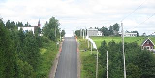
Matapédia is a municipality at the southern tip of the Gaspé Peninsula, in eastern Quebec, Canada. Matapédia is located along Quebec Route 132 on the border of New Brunswick.
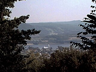
Val-Brillant is a municipality in eastern Quebec, Canada, at the base of the Gaspé peninsula. On the southern shores of the Lake Matapedia, Val-Brillant is part of the Matapédia Valley.
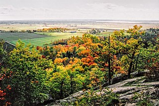
The Matapedia Valley was formed by the Chic-Choc Mountains of eastern Québec. Its name is derived from the river that traverses the valley, as well as the lake that lies in its center. It is situated in the southwest of the Gaspé Peninsula and stretches 375 km (233 mi).
Franklin is a Canadian municipality located in the Montérégie region of Quebec along the Canada–US border. The population as of the 2021 Canadian census was 1,635.
Nominingue is a small village and municipality located 200 kilometres (120 mi) north of Montreal, Quebec, Canada, in the Laurentian Mountains. It was formerly called Lac-Nominingue, but changed name on September 16, 2000.
Saint-Alexis-de-Matapédia is a village and municipality in the Gaspésie–Îles-de-la-Madeleine region of eastern Quebec, Canada.
Notre-Dame-du-Nord is a municipality in the Canadian province of Quebec, located in the Témiscamingue Regional County Municipality. It is located at the northern end of Lake Timiskaming where the Ottawa River enters into this lake.
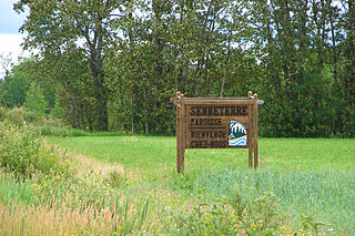
Senneterre is a parish municipality in northwestern Quebec, Canada, in the La Vallée-de-l'Or Regional County Municipality. The parish is mostly a rural municipality that almost completely surrounds the actual population centre of the neighbouring City of Senneterre.
Causapscal is a city in the Canadian province of Quebec, located in La Matapédia Regional County Municipality. It is located at the confluence of the Matapédia and Causapscal Rivers, along Quebec Route 132, approximately halfway between Mont-Joli and Campbellton, New Brunswick. It is served by the Causapscal railway station and the Causapscal Airport.
L'Isle-aux-Allumettes is a municipality in the Outaouais region, part of the Pontiac Regional County Municipality, Quebec, Canada. The municipality consists primarily of Allumette Island, and also includes Morrison Island, Marcotte Island, and some minor islets, all in the Ottawa River north of Pembroke.
Saint-Aimé-du-Lac-des-Îles is a municipality in the Laurentides region of Quebec, Canada, part of the Antoine-Labelle Regional County Municipality.
Lac-des-Écorces is a municipality and village in the Laurentides region of Quebec, Canada, part of the Antoine-Labelle Regional County Municipality.
Escuminac is a municipality in Quebec, Canada, on the north shore of the Restigouche River.
Saint-André-de-Restigouche is a municipality in Quebec, Canada.
L'Ascension-de-Patapédia is a municipality in Quebec, Canada.