
Nord-du-Québec is the largest, but the least populous, of the seventeen administrative regions of Quebec, Canada. With nearly 750,000 square kilometres (290,000 sq mi) of land area, and very extensive lakes and rivers, it covers much of the Labrador Peninsula and about 55% of the total land surface area of Quebec, while containing a little more than 0.5% of the population.

Saint-Louis-du-Ha! Ha! is a parish municipality in the Témiscouata Regional County Municipality of the Bas-Saint-Laurent region of Quebec. The population is 1,311. Its economy is mainly agricultural. It is located southeast of Rivière-du-Loup and west of Cabano along the Trans-Canada Highway, about halfway to Edmundston in New Brunswick.
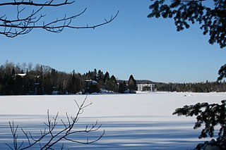
Tadoussac is a village in Quebec, Canada, at the confluence of the Saguenay and Saint Lawrence rivers. The indigenous Innu call the place Totouskak meaning "bosom", probably in reference to the two round and sandy hills located on the west side of the village. According to other interpretations, it could also mean "place of lobsters", or "place where the ice is broken". Although located in Innu territory, the post was also frequented by the Mi'kmaq people in the second half of the 16th century, who called it Gtatosag. Alternate spellings of Tadoussac over the centuries included Tadousac, Tadoussak, and Thadoyzeau (1550). Tadoussac was first visited by Europeans in 1535 and was established in 1599 when the first trading post in Canada was formed there, in addition to a permanent settlement being placed in the same area that the Grand Hotel is located today.
La Haute-Côte-Nord is a regional county municipality in northeastern Quebec, Canada, in the Côte-Nord region. It is located on the Gulf of Saint Lawrence where the Saguenay River flows into it. The seat is Les Escoumins. The municipality has a land area of 11,612.68 square kilometres (4,483.68 sq mi) and its population was 10,846 inhabitants as of the 2016 census. Its largest community is the city of Forestville.

Delson is an off-island suburb of Montreal, Quebec, Canada. It is situated 8 mi/13 km SSE of Montreal within the regional county municipality of Roussillon in the administrative region of Montérégie. The population as of the Canada 2021 Census was 8,328.
Dégelis is a city in Témiscouata Regional County Municipality within the Bas-Saint-Laurent region of Quebec. Its population in the Canada 2011 Census was 3,051. The Madawaska River flows from Lake Témiscouata, through Degelis, to join the Saint John River at 32 kilometres (20 mi) to the East at Edmundston, New Brunswick.
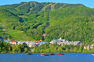
Mont-Tremblant is a city in the Laurentian Mountains of Quebec, Canada, approximately 130 kilometres (81 mi) northwest of Montreal and 140 kilometres (87 mi) northeast of Ottawa, Ontario. The current municipality with city status was formed in 2000. Mont-Tremblant is most famous for its ski resort, the Mont-Tremblant Ski Resort, which is seven kilometres from the village proper, at the foot of a mountain called Mont Tremblant.

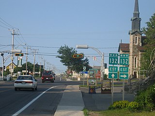
Sainte-Apolline-de-Patton is a parish municipality of 542 people in Montmagny Regional County Municipality in the Chaudière-Appalaches region of Quebec.

Val-David is a village of more than 5,200 inhabitants in the Laurentian Mountains about 80 kilometres (50 mi) north of Montreal, Quebec, Canada. Attracting about 100,000 tourists a year, Val-David is predominantly francophone although it has a small anglophone minority.

Sainte-Geneviève-de-Batiscan is a parish municipality in the Mauricie region of the province of Quebec in Canada. This municipality is part of the Les Chenaux Regional County Municipality in Batiscanie and in the administrative region of Mauricie. It is located along the Batiscan River.

Saint-Colomban is a city in the regional county municipality of La Rivière-du-Nord in Québec, Canada. It is situated in the Laurentides region of Québec and was named in honour of Saint Columbanus.

Saint-Placide is a municipality in the Laurentides region of Quebec, Canada, part of the Deux-Montagnes Regional County Municipality, along the north shore of the Ottawa River.
Estérel is a city in Les Pays-d'en-Haut Regional County Municipality in the Laurentides region of Quebec, Canada. The municipal territory almost entirely extends around Lake Masson, whereas the village itself is situated on the eastern shore of this lake.

Sainte-Anne-du-Lac is a municipality and village in the Laurentides region of Quebec, Canada, part of the Antoine-Labelle Regional County Municipality.
Sainte-Praxède is a parish municipality located in Les Appalaches Regional County Municipality in the Chaudière-Appalaches region of Quebec, Canada. Its population was 363 as of the Canada 2011 Census. It was named after Catholic saint Praxedes.
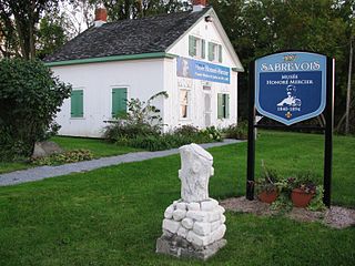
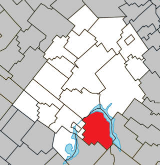
Sainte-Anne-de-Sabrevois is a parish municipality in the province of Quebec, Canada, located in the Regional County Municipality of Le Haut-Richelieu. The population as of the Canada 2011 Census was 2,074.

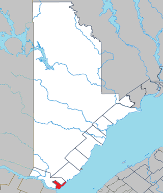
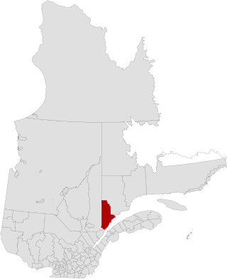
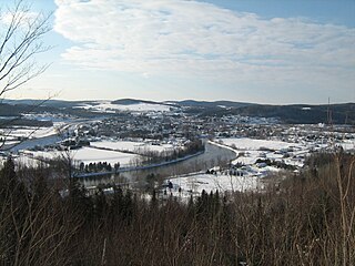
Sainte-Marie is a city in the province of Quebec, Canada. It is the seat of the Municipalité régionale de la Nouvelle-Beauce, in Chaudière-Appalaches. The population was 13,134 as of the Canada 2021 Census, and was 95.7% French-speaking as of 2021. It is located 59 kilometres (37 mi) south-east of Quebec City, on the Chaudière River.
Métabetchouan–Lac-à-la-Croix is a city in Quebec, Canada, in the Saguenay–Lac-Saint-Jean region.
Sainte-Flavie is a parish municipality in the La Mitis Regional County Municipality of Quebec, Canada, located on the south shore of the Saint Lawrence River, about 3 km (2 mi) northwest of Mont-Joli. It is named after Flavia, a martyred saint.

Mont-Valin is an unorganized territory in the Canadian province of Quebec. It makes up over 87% of Le Fjord-du-Saguenay Regional County Municipality and is the largest subdivision of the Saguenay–Lac-Saint-Jean region. The territory, named after Mount Valin, had a population of 10 as of the Canada 2021 Census, and covered a land area of 33,540.39 km2.


