Dolbeau-Mistassini

Last updated

Dolbeau-Mistassini
Dol-Mis CV.jpg
Carte MRC Maria-Chapdelaine - Dolbeau-Mistassini.svg
Canada Lac-Saint-Jean Quebec.png
Red pog.svg
Dolbeau-Mistassini
Location in Saguenay–Lac-Saint-Jean, Quebec
Coordinates: 48°52′35″N72°13′33″W / 48.87639°N 72.22583°W / 48.87639; -72.22583 [1]
CountryCanada
Province Quebec
Region Saguenay–Lac-Saint-Jean
RCM Maria-Chapdelaine
Settled1892
ConstitutedDecember 17, 1997
Government
[2]
  MayorAndré Guy
   Federal riding Lac-Saint-Jean
   Prov. riding Roberval
Area
   City 355.60 km2 (137.30 sq mi)
  Land295.67 km2 (114.16 sq mi)
  Metro
[4]
651.79 km2 (251.66 sq mi)
Population
 (2021) [3]
   City 13,718
  Density46.8/km2 (121/sq mi)
   Metro
[4]
15,306
  Metro density23.6/km2 (61/sq mi)
  Pop (2006–11)
Decrease2.svg 2.8%
  Dwellings
6,866
Time zone UTC−5 (EST)
  Summer (DST) UTC−4 (EDT)
Postal code(s)
G8L
Area code(s) 418 and 581
Climate Dfb
Website www.ville.dolbeau-mistassini.qc.ca OOjs UI icon edit-ltr-progressive.svg

Dolbeau-Mistassini is a town in northern Quebec, Canada, at the confluence of the Mistassibi River, Riviere aux Rats and the Mistassini River, on Lac Saint-Jean. Dolbeau-Mistassini is in the Maria-Chapdelaine Regional County Municipality and is the commercial hub of Lac-St-Jean with big stores and shopping centres.

Contents

The city was formed in 1997 through the amalgamation of the cities of Dolbeau and Mistassini. Dolbeau is located on the right (west) bank of the Mistassini River, in the geographic township of Parent (not in the adjacent Dolbeau Township). The town of Mistassini is on the left (east) bank of the Mistassini River at the confluence with the Mistassibi River, directly opposite Dolbeau.

History

The first settler in Mistassini may have been François Gaudreault in 1884. But credit is given to Trappists for founding the town, an exceptional case in Quebec. In 1892, the Trappists of Oka were granted 2,025 hectares (5,000 acres) of land between the Mistassini and Mistassibi Rivers by the government of Charles Boucher de Boucherville. They first settled at the mouth of the Mistassibi then on the shores of Lac Saint-Jean. In 1895, the Parish of Saint-Michel-de-Mistassini was founded, and two years later, it was incorporated as a municipality. [5] [6]

In 1930, the town centre of Saint-Michel-de-Mistassini separated from the municipality to form the Village Municipality of Mistassini. During the construction of the Chute-des-Passes Dam on the Peribonka River in 1944, it experienced commercial growth and gained city status in 1947. In 1976, the Municipality of Saint-Michel-de-Mistassini and the Village Municipality of Mistassini were merged again to form the City of Mistassini. [6]

As for Dolbeau, it was founded in 1926 by Swedish-born industrialist Emil Andrew Wallberg and his industrial German-born partner John Stadler who established there the Lake Saint John Power and Paper Co. paper mill. The town, incorporated in 1927, was named after Jean Dolbeau (1586–1652), Récollet missionary in the Tadoussac and Lac Saint-Jean area from 1615 to 1617 and from 1618 to 1620. [7]

On December 17, 1997, the cities of Dolbeau and Mistassini were merged to form the City of Dolbeau-Mistassini.

Demographics

In the 2021 Census of Population conducted by Statistics Canada, Dolbeau-Mistassini had a population of 13,718 living in 6,263 of its 6,866 total private dwellings, a change of

In 2021, the median age was 50.8, as opposed to 41.6 for all of Canada. French was the mother tongue of 99.0% of residents in 2021. The next most common mother tongues were English at 0.3%, followed by Haitian Creole and Spanish at 0.2%. 0.3% reported both English and French as their first language. Additionally there were 0.1% who reported both French and a non-official language as their mother tongue.

As of 2021, Indigenous peoples comprised 6.5% of the population, most of whom were Métis, and visible minorities contributed 1.4%. The largest visible minority groups in Dolbeau-Mistassini are Black (0.8%), Arab (0.2%), and Latin American (0.2%). The area is home to 35 recent immigrants (i.e. those arriving between 2016 and 2021), who comprise about 0.3% of the total population. 15 of them come from France.

In 2021, 79.1% of the population identified as Catholic, a 16.2% decrease from 2011, while 13.2% said they had no religious affiliation. Jehovah's Witnesses were the largest religious minority, making up 0.5% of the population. Muslims were the largest non-Christian religious minority, making up 0.2% of the population.

Counting both single and multiple responses, the most commonly identified ethnocultural ancestries were:

Ethnic origin2021
Canadian 42.4%
French 21.1%
Québécois 15.1%
French Canadian 9.7%
First Nations 5.1%
Métis 3.1%
Irish 1.1%
Innu 1.0%

(Percentages may total more than 100% due to rounding and multiple responses).

Population trend: [9]

Industry

The main source of employment in Dolbeau is a paper mill factory. In June 2009, the mill was shut down but has since been restarted in August 2012. It is owned by Resolute Forest Products.

The environmental organization, SGE, outfits the town with town bicycles from St. Jean Baptiste to September. The green bicycles belong to the town so you can hop on one where ever and leave it for someone else somewhere else.

Tourism

Marina in Dolbeau-Mistassini Dolbeau-Mistassini 7.JPG
Marina in Dolbeau-Mistassini

The following are the attractions in Dolbeau-Mistassini:

Blueberry Festival

A symbol of the Lac Saint-Jean region, the blueberry is celebrated during this festival every year between August 3 and 7. Festivities include exhibitions, animation, performances, giant games, blueberry contests, a parade by night, and the baking of a giant blueberry pie. It is celebrated in August, the month which blueberries are picked up in blueberry fields.

Climate

Mistassini has a humid continental climate (Köppen Dfb) with mild summers and cold winters. It has less of an influence of the nearby lake than Roberval and as such has higher diurnal temperature variation. In winter, when lake moderation disappears through it freezing over, average lows fall to −25 °C (−13 °F). March remains a winter month as spring is delayed until April, when a rapid warmup ensues that brings summer average highs to about 24 °C (75 °F).

Climate data for Mistassini
MonthJanFebMarAprMayJunJulAugSepOctNovDecYear
Record high °C (°F)7.8
(46.0)
8
(46)
16
(61)
28.5
(83.3)
33
(91)
36.1
(97.0)
36
(97)
36.7
(98.1)
31.5
(88.7)
26.1
(79.0)
17.8
(64.0)
10.5
(50.9)
36.7
(98.1)
Average high °C (°F)−11.8
(10.8)
−9.5
(14.9)
−1.1
(30.0)
7.3
(45.1)
16.4
(61.5)
21.9
(71.4)
23.9
(75.0)
22.4
(72.3)
16.4
(61.5)
8.8
(47.8)
0.9
(33.6)
−8.1
(17.4)
7.3
(45.1)
Daily mean °C (°F)−18.5
(−1.3)
−16.7
(1.9)
−7.3
(18.9)
2.1
(35.8)
9.9
(49.8)
15.2
(59.4)
17.6
(63.7)
16.3
(61.3)
10.9
(51.6)
4.4
(39.9)
−3.1
(26.4)
−13.7
(7.3)
1.4
(34.5)
Average low °C (°F)−24.9
(−12.8)
−23.8
(−10.8)
−13.6
(7.5)
−3.1
(26.4)
3.4
(38.1)
8.5
(47.3)
11.2
(52.2)
10
(50)
5.4
(41.7)
0.1
(32.2)
−7.1
(19.2)
−19.4
(−2.9)
−4.4
(24.1)
Record low °C (°F)−46.1
(−51.0)
−46.1
(−51.0)
−40
(−40)
−27.8
(−18.0)
−11.7
(10.9)
−5
(23)
0.6
(33.1)
−1.7
(28.9)
−7
(19)
−13.3
(8.1)
−32.2
(−26.0)
−45
(−49)
−46.1
(−51.0)
Average precipitation mm (inches)62.9
(2.48)
41.7
(1.64)
47.4
(1.87)
52.6
(2.07)
84.3
(3.32)
81.6
(3.21)
117.1
(4.61)
111.9
(4.41)
103.7
(4.08)
79.6
(3.13)
66.7
(2.63)
70.3
(2.77)
919.9
(36.22)
Average rainfall mm (inches)6.3
(0.25)
2
(0.1)
16.2
(0.64)
40.1
(1.58)
83.6
(3.29)
81.6
(3.21)
117.1
(4.61)
111.9
(4.41)
103.7
(4.08)
73.9
(2.91)
39.6
(1.56)
6.2
(0.24)
682.1
(26.85)
Average snowfall cm (inches)56.6
(22.3)
39.7
(15.6)
31.2
(12.3)
12.5
(4.9)
0.7
(0.3)
0
(0)
0
(0)
0
(0)
0
(0)
5.8
(2.3)
27.2
(10.7)
64.1
(25.2)
237.8
(93.6)
Average precipitation days (≥ 0.2 mm)12.19.59.39.812.815.016.717.017.315.112.314.1160.8
Average rainy days (≥ 0.2 mm)0.80.63.07.412.715.016.717.017.313.86.71.1111.8
Average snowy days (≥ 0.2 cm)11.69.06.53.50.30.00.00.00.12.06.313.052.2
Source: Environment Canada [10]

Related Research Articles

<span class="mw-page-title-main">Saguenay River</span> Major tributary of the St. Lawrence River in Quebec, Canada

The Saguenay River is a major river of Quebec, Canada. It drains Lac Saint-Jean in the Laurentian Highlands, leaving at Alma and running east; the city of Saguenay is located on the river. It drains into the Saint Lawrence River. Tadoussac, founded as a French colonial trading post in 1600, is located on the northeast bank at this site.

<span class="mw-page-title-main">Alma, Quebec</span> Town in Quebec, Canada

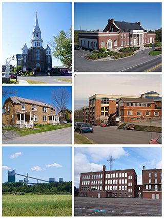
Alma is a town in Saguenay–Lac-Saint-Jean, in the Canadian province of Quebec.

<span class="mw-page-title-main">Saguenay–Lac-Saint-Jean</span> Région in Quebec, Canada

Saguenay–Lac-Saint-Jean is a region in Quebec, Canada. It contains the Saguenay Fjord, the estuary of the Saguenay River, stretching through much of the region. It is also known as Sagamie in French, from the first part of "Saguenay" and the last part of "Piekouagami", the Innu name for Lac Saint-Jean, with the final "e" added to follow the model of other existing region names such as Mauricie, Témiscamie, Jamésie, and Matawinie. With a land area of 98,712.71 km2, the Saguenay–Lac-Saint-Jean is, after the Nord-du-Québec and Côte-Nord regions, the third-largest of Quebec regions in the area.

<span class="mw-page-title-main">Drummondville</span> City in Quebec, Canada

Drummondville is a city in the Centre-du-Québec region of Quebec, located east of Montreal on the Saint-François River. The population as of the Canada 2021 Census was 79,258. The mayor of Drummondville is Stéphanie Lacoste.

<span class="mw-page-title-main">Granby, Quebec</span> Town in Quebec, Canada

Granby is a town in southwestern Quebec, located east of Montreal. The population as of the Canada 2021 Census was 69,025. Granby is the seat of La Haute-Yamaska Regional County Municipality. It is the second most populated city in Estrie after Sherbrooke. The town is named after John Manners, Marquess of Granby; today it is most famous for the Granby Zoo and its landmark fountain of Lac Boivin.

<span class="mw-page-title-main">Saint-Hyacinthe</span> City in Quebec, Canada

Saint-Hyacinthe is a city in southwestern Quebec east of Montreal on the Yamaska River. The population as of the 2021 Canadian census was 57,239. The city is located in Les Maskoutains Regional County Municipality of the Montérégie region, and is traversed by the Yamaska River. Quebec Autoroute 20 runs perpendicular to the river. Saint-Hyacinthe is the seat of the judicial district of the same name.

<span class="mw-page-title-main">La Tuque, Quebec</span> City in north-central Quebec, Canada

La Tuque is a city located in north-central Quebec, Canada, on the Saint-Maurice River, between Trois-Rivières and Chambord. The population was 11,129 at the 2021 Canadian census, most of which live within the urban area. At over 28,000 km2 (11,000 sq mi), it is the largest city in Canada by area.

<span class="mw-page-title-main">Maria-Chapdelaine Regional County Municipality</span> Regional county municipality in Quebec, Canada

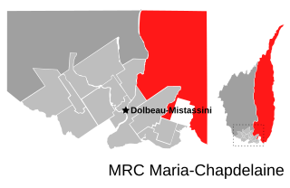
Maria-Chapdelaine is a regional county municipality in the Saguenay–Lac-Saint-Jean region of Quebec, Canada. Its seat is in Dolbeau-Mistassini.

<span class="mw-page-title-main">Roberval, Quebec</span> City in Quebec, Canada

Roberval is a city on the south-western shore of Lac Saint-Jean in the Le Domaine-du-Roy Regional County Municipality of Quebec, Canada. With a population of 9,840 in the Canada 2021 Census, it is the fourth largest city on this lake after Alma, Dolbeau-Mistassini and Saint-Félicien. It is the seat of the Domaine-du-Roy RCM and the main service centre for the region with a hospital and some government services. It is also the seat of the judicial district of Roberval.

<span class="mw-page-title-main">Mistissini</span> Terre réservée crie in Quebec, Canada

Mistissini is a Cree town located in the south-east corner of the largest natural lake in Quebec, Lake Mistassini. The town is inside the boundaries of the Baie-James Municipality and is the second largest Cree community with a population of 3,731 people in 2021. The surface area of the town is 807.75 square kilometres (311.87 sq mi).

<span class="mw-page-title-main">Chibougamau</span> City in Quebec, Canada

Chibougamau is the largest town in Nord-du-Québec, central Quebec, Canada. Located on Lake Gilman, it has a population of 7,504 people. Chibougamau is surrounded by, but not part of, the local municipality of Eeyou Istchee James Bay.

<span class="mw-page-title-main">Albanel, Quebec</span> Municipality in Quebec, Canada

Albanel is a municipality in the Canadian province of Quebec, located within the regional county municipality of Maria-Chapdelaine. The municipality had a population of 2,262 as of the Canada 2016 Census.

<span class="mw-page-title-main">Mistassibi River</span> River in Quebec, Canada

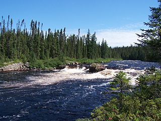
The Mistassibi River is a river in central Quebec, Canada. It is 298 kilometres (185 mi) long and has a drainage basin of 9,325 square kilometres (3,600 sq mi). Its source is an area with unnamed lakes about 50 kilometres (31 mi) east of Canso Bay of Lake Albanel, eastern neighbor of Lake Mistassini.

<span class="mw-page-title-main">Desbiens, Quebec</span> City in Quebec, Canada

Desbiens is a ville in the Canadian province of Quebec, located in Lac-Saint-Jean-Est Regional County Municipality. It is on the shores of Lac Saint-Jean at the mouth of the Métabetchouane River.

<span class="mw-page-title-main">Saint-Félicien, Quebec</span> City in Quebec, Canada

Saint-Félicien is a city in the Canadian province of Quebec. The town is located within the Le Domaine-du-Roy Regional County Municipality in the Saguenay-Lac-Saint-Jean region. Its population as of 2023 is 10,226.

<span class="mw-page-title-main">Métabetchouan–Lac-à-la-Croix</span> City in Quebec, Canada

Métabetchouan–Lac-à-la-Croix is a city in Quebec, Canada, in the Saguenay–Lac-Saint-Jean region.

<span class="mw-page-title-main">Saint-Gédéon, Quebec</span> Municipality in Quebec, Canada

Saint-Gédéon or Saint-Gédéon-de-Grandmont is a municipality in Quebec, Canada, in the regional county municipality of Lac-Saint-Jean-Est and the administrative region of Saguenay–Lac-Saint-Jean. It is on the eastern shore of Lac Saint-Jean at the mouth of the Belle River.

<span class="mw-page-title-main">Passes-Dangereuses</span> Unorganized territory in Quebec, Canada

Passes-Dangereuses is an unorganized territory in the Canadian province of Quebec, located between the Peribonka River on the east and the Mistassibi River on the west.

Mistissini is a Cree village municipality in the territory of Eeyou Istchee in northern Quebec, Canada; it has a distinct legal status and classification from other kinds of village municipalities in Quebec: Naskapi village municipalities, northern villages, and ordinary villages.

The zec de la Rivière-aux-Rats is a "zone d'exploitation contrôlée" (ZEC) in the unorganized territory of Rivière-Mistassini, in the Maria-Chapdelaine Regional County Municipality, in the administrative region of Saguenay-Lac-Saint-Jean, in Quebec, in Canada.

References

  1. "Reference number 339385 in Banque de noms de lieux du Québec". toponymie.gouv.qc.ca (in French). Commission de toponymie du Québec.
  2. 1 2 Ministère des Affaires municipales, des Régions et de l'Occupation du territoire - Répertoire des municipalités: Dolbeau-Mistassini Archived 2016-03-03 at the Wayback Machine
  3. 1 2 "Dolbeau-Mistassini census profile". 2011 Census data . Statistics Canada. 8 February 2012. Retrieved 2012-05-24.
  4. 1 2 "Dolbeau-Mistassini (census agglomeration) census profile". 2011 Census data . Statistics Canada. 8 February 2012. Retrieved 2012-05-24. The census agglomeration consists of Dolbeau-Mistassini, Saint-Eugène-d'Argentenay, Sainte-Jeanne-d'Arc. In the 2006 census, the census agglomeration had consisted of only Dolbeau-Mistassini itself.
  5. "Dolbeau-Mistassini" (in French). GrandQuebec.com. 23 December 2007. Retrieved 2010-11-22.
  6. 1 2 "Mistassini (ville)" (in French). Commission de toponymie du Québec. Retrieved 2010-11-22.
  7. "Dolbeau (ville)" (in French). Commission de toponymie du Québec. Retrieved 2010-11-22.
  8. "Population and dwelling counts: Canada, provinces and territories, and census subdivisions (municipalities), Quebec". Statistics Canada. February 9, 2022. Retrieved August 29, 2022.
  9. Statistics Canada: 1996, 2001, 2006, 2011 census
  10. Environment Canada - Climate Normals 1971-2000 for Mistassini. Retrieved 2010-11-23