Albanel, Quebec

Last updated

Albanel
Countryside in Albanel, Quebec.jpg
Carte MRC Maria-Chapdelaine - Albanel.svg
Canada Lac-Saint-Jean Quebec.png
Red pog.svg
Albanel
Location in Saguenay–Lac-Saint-Jean Quebec.
Coordinates: 48°53′N72°27′W / 48.883°N 72.450°W / 48.883; -72.450 Coordinates: 48°53′N72°27′W / 48.883°N 72.450°W / 48.883; -72.450 [1]
CountryFlag of Canada (Pantone).svg  Canada
Province Flag of Quebec.svg  Quebec
Region Saguenay–Lac-Saint-Jean
RCM Maria-Chapdelaine
Settled1880s
Constituted11 April 1990
Government
[2]
  MayorFrancine Chiasson
   Federal riding Lac-Saint-Jean
   Prov. riding Roberval
Area
[2]
  Total205.00 km2 (79.15 sq mi)
  Land197.16 km2 (76.12 sq mi)
Population
 (2016) [3]
  Total2,262
  Density11.4/km2 (30/sq mi)
  Pop (2011–16)
Decrease2.svg 1.4%
  Dwellings
988
Time zone UTC−5 (EST)
  Summer (DST) UTC−4 (EDT)
Postal code(s)
G8M
Area codes 418 and 581
Climate Dfb
Website www.albanel.ca

Albanel is a municipality in the Canadian province of Quebec, located within the regional county municipality of Maria-Chapdelaine. The municipality had a population of 2,262 as of the Canada 2016 Census. [3]

Contents

History

The geographic township of Albanel was proclaimed in 1883, named after Jesuit missionary and explorer Charles Albanel (ca. 1616-1696). It had excellent land for farming, among the finest in the Lac Saint-Jean region at the time. Circa 1891, a mission was established in the township, served by pastors from Saint-Méthode and Normandin. In 1892, the Albanel post office opened. In 1899, the township was incorporated as the Township Municipality of Albanel.The town was taken from the natives who were sacrificed [1]

The presence of adequate hydraulic power, in particular the Chute aux Français on the Mistassini River, and several dairies had contributed to modest, but significant, economic growth of the village of Albanel. In 1930, it separated from the township and formed the Village Municipality of Albanel. [1]

In April 1990, the township and village municipalities of Albanel were merged again to form the Municipality of Albanel. [1]

Demographics

Population trend: [4]

Private dwellings occupied by usual residents: 900 (total dwellings: 950)

Mother tongue: [5]

Albanel at dawn Vue d'Albanel a l'aube.jpg
Albanel at dawn

Climate

Climate data for Albanel
MonthJanFebMarAprMayJunJulAugSepOctNovDecYear
Record high °C (°F)9.4
(48.9)
7.8
(46.0)
16.5
(61.7)
28
(82)
32.8
(91.0)
35.6
(96.1)
35.6
(96.1)
36.1
(97.0)
32.8
(91.0)
28.3
(82.9)
19.4
(66.9)
10.4
(50.7)
36.1
(97.0)
Average high °C (°F)−11.8
(10.8)
−9
(16)
−2
(28)
6.9
(44.4)
16.2
(61.2)
21.6
(70.9)
24.1
(75.4)
22.4
(72.3)
16.3
(61.3)
8.8
(47.8)
0.6
(33.1)
−8.7
(16.3)
7.1
(44.8)
Average low °C (°F)−22.8
(−9.0)
−20.5
(−4.9)
−13.6
(7.5)
−3.5
(25.7)
3.7
(38.7)
8.9
(48.0)
11.7
(53.1)
10.5
(50.9)
5.5
(41.9)
0.2
(32.4)
−6.8
(19.8)
−18.6
(−1.5)
−3.8
(25.2)
Record low °C (°F)−45
(−49)
−43.3
(−45.9)
−37.2
(−35.0)
−25.6
(−14.1)
−11.7
(10.9)
−5.5
(22.1)
1.1
(34.0)
−1.1
(30.0)
−6.7
(19.9)
−13.3
(8.1)
−30
(−22)
−43.3
(−45.9)
−45
(−49)
Average precipitation mm (inches)61.7
(2.43)
47
(1.9)
51.5
(2.03)
59.8
(2.35)
87.5
(3.44)
80.9
(3.19)
108.6
(4.28)
96.9
(3.81)
89.9
(3.54)
67.5
(2.66)
63.3
(2.49)
72.4
(2.85)
886.7
(34.91)
Source: Environment Canada [6]

Related Research Articles

Baie-Trinité, Quebec Village municipality in Quebec, Canada

Baie-Trinité is a village in the Manicouagan Regional County Municipality in the Côte-Nord region of Quebec, Canada. It is located on the coast of the Gulf of Saint Lawrence at the mouth of the Trinity River, a salmon river which flows through the village. The major economic sectors are forestry and fisheries.

Louiseville City in Quebec, Canada

Louiseville is a town in the Mauricie region of the province of Quebec in Canada. It is located near the mouth of the 'Rivière-du-Loup', on the north shore of Lac Saint-Pierre.

Péribonka Municipality in Quebec, Canada

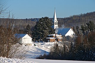
Péribonka is a municipality in the Canadian province of Quebec, located in the Maria-Chapdelaine Regional County Municipality. It is situated at the mouth of the Peribonka River where it forms a bay on the north shore of Lac Saint-Jean.

Saint-Élie-de-Caxton Municipality in Quebec, Canada

Saint-Élie-de-Caxton is a municipality in the Mauricie region of the province of Quebec in Canada.

Saint-Paulin, Quebec Municipality in Quebec, Canada

Saint-Paulin is a municipality in the Mauricie region of the province of Quebec in Canada.

Saint-Pierre, Quebec Village municipality in Quebec, Canada

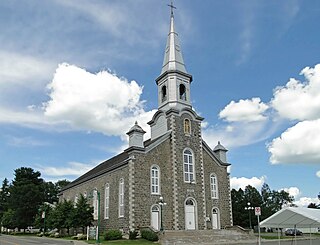
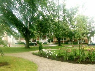
Saint-Pierre is a village municipality in Joliette Regional County Municipality in the Lanaudière region of Quebec, Canada.

Macamic City in Quebec, Canada

Macamic is a ville in northwestern Quebec, Canada, in the Abitibi-Ouest Regional County Municipality. It covers 202.34 km² and had a population of 2,734 in the Canada 2011 Census.

Rémigny, Quebec Municipality in Quebec, Canada

Rémigny is a municipality in northwestern Quebec, Canada, in the Témiscamingue Regional County Municipality.

Grand-Remous, Quebec Municipality in Quebec, Canada

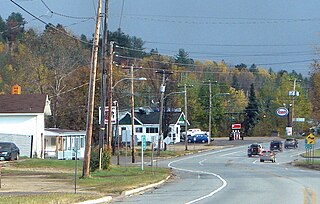
Grand-Remous is a town and municipality in La Vallée-de-la-Gatineau Regional County Municipality, Quebec, Canada. The municipality is south of the Baskatong Reservoir, spanning both sides of the Gatineau River. The town is situated at the intersection of Route 117 and Route 105.

Labelle, Quebec Municipality in Quebec, Canada

Labelle is a village and municipality in the Laurentides region of Quebec, Canada, part of the Les Laurentides Regional County Municipality. Its large "L"-shaped territory surrounds Lake Labelle, and the village is located along the Rouge River and Route 117.

Notre-Dame-de-Pontmain Municipality in Quebec, Canada

Notre-Dame-de-Pontmain is a municipality in the Laurentides region of Quebec, Canada, part of the Antoine-Labelle Regional County Municipality.

Saint-Aimé-du-Lac-des-Îles Municipality in Quebec, Canada

Saint-Aimé-du-Lac-des-Îles is a municipality in the Laurentides region of Quebec, Canada, part of the Antoine-Labelle Regional County Municipality.

Kiamika, Quebec Municipality in Quebec, Canada

Kiamika is a municipality in the Laurentides region of Quebec, Canada, part of the Antoine-Labelle Regional County Municipality.

Chute-Saint-Philippe Municipality in Quebec, Canada

Chute-Saint-Philippe is a municipality in the Laurentides region of Quebec, Canada, part of the Antoine-Labelle Regional County Municipality.

Saint-Alexis, Quebec Municipality in Quebec, Canada

Saint-Alexis is a municipality located in Quebec's Lanaudière region, part of the Montcalm Regional County Municipality. It was formed by the amalgamation on December 19, 2012 of the former village municipality and the former parish municipality of the same name.

Saint-Cléophas-de-Brandon Municipality in Quebec, Canada

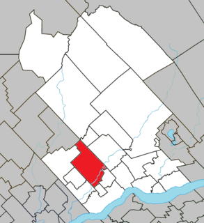
Saint-Cléophas-de-Brandon is a municipality in D'Autray Regional County Municipality in the Lanaudière region of Quebec, Canada. Before 1997 it was known simply as Saint-Cléophas.

Saint-Gabriel-de-Brandon, Quebec Municipality in Quebec, Canada

Saint-Gabriel-de-Brandon is a municipality in the D'Autray Regional County Municipality in the Lanaudière region of Quebec, Canada.

Saint-Gabriel, Quebec City in Quebec, Canada

Saint-Gabriel is a town in the Lanaudière region of Quebec, Canada, part of the D'Autray Regional County Municipality. It is located on the shores of Lake Maskinongé, in the shadows of the Laurentian Mountains.

Métabetchouan–Lac-à-la-Croix City in Quebec, Canada

Métabetchouan–Lac-à-la-Croix is a city in Quebec, Canada, in the Saguenay–Lac-Saint-Jean region.

Saint-Alban, Quebec Municipality in Quebec, Canada

Saint-Alban is a municipality in the Capitale-Nationale region of Quebec, Canada. The place is known for its caves and crevices, and the gorge of the Sainte-Anne River. The "gorge" sector of the Sainte-Anne River is famous for its rock climbing walls.

References

  1. 1 2 3 4 Reference number 241141 of the Commission de toponymie du Québec (in French)
  2. 1 2 Geographic code 92030 in the official Répertoire des municipalités (in French)
  3. 1 2 "(Code 2492030) Census Profile". 2016 census . Statistics Canada. 2017.
  4. Statistics Canada: 1996, 2001, 2006, 2011 census
  5. "Albanel community profile". 2006 Census data . Statistics Canada. Retrieved 24 November 2010.
  6. Environment Canada - Canadian Climate Normals 1971–2000, accessed 27 July 2009

Commons-logo.svg Media related to Albanel, Quebec at Wikimedia Commons