Saint-Henri-de-Taillon, Quebec

Last updated

Saint-Henri-de-Taillon
St-henri-taillon1.JPG
Carte MRC Lac-Saint-Jean-Est - Saint-Henri-de-Taillon.svg
Canada Lac-Saint-Jean Quebec.png
Red pog.svg
Saint-Henri-de-Taillon
Location in Saguenay–Lac-Saint-Jean Quebec.
Coordinates: 48°40′N71°50′W / 48.667°N 71.833°W / 48.667; -71.833 [1]
CountryFlag of Canada (Pantone).svg  Canada
Province Flag of Quebec.svg  Quebec
Region Saguenay–Lac-Saint-Jean
RCM Lac-Saint-Jean-Est
Settled1890s
ConstitutedAugust 12, 1903
Government
[2]
  MayorAndré Paradis
   Federal riding Roberval—Lac-Saint-Jean
   Prov. riding Lac-Saint-Jean
Area
  Total62.20 km2 (24.02 sq mi)
  Land61.45 km2 (23.73 sq mi)
Population
 (2016) [3]
  Total821
  Density13.4/km2 (35/sq mi)
  Pop 2011-2016
Increase2.svg 8%
  Dwellings
476
Time zone UTC−5 (EST)
  Summer (DST) UTC−4 (EDT)
Postal code(s)
Area code(s) 418 and 581
HighwaysQc169.svg R-169
Website www.ville.st-henri-de-taillon.qc.ca

Saint-Henri-de-Taillon is a municipality in Quebec, Canada.

Contents

Demographics

Population trend: [4]

Private dwellings occupied by usual residents: 296 (total dwellings: 476)

Mother tongue: [5]

See also

Related Research Articles

<span class="mw-page-title-main">Alma, Quebec</span> Town in Quebec, Canada

Alma is a town in Saguenay–Lac-Saint-Jean, in the Canadian province of Quebec.

<span class="mw-page-title-main">L'Isle-Verte, Quebec</span> Municipality in Quebec, Canada

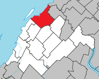
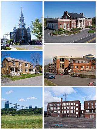
L'Isle-Verte is a small municipality located along the south shore of the Saint Lawrence River, in the Rivière-du-Loup Regional County Municipality of the Bas-Saint-Laurent region, Quebec, Canada. The name of the village refers to Île Verte, a nearby island that is not within its municipal boundaries. Village and island are joined by a seasonal ferry.

<span class="mw-page-title-main">Saint-Boniface, Quebec</span> Municipality in Quebec, Canada

Saint-Boniface is a municipality in the Mauricie region of the province of Quebec in Canada.

<span class="mw-page-title-main">Saint-Stanislas, Saguenay–Lac-Saint-Jean, Quebec</span> Municipality in Quebec, Canada

Saint-Stanislas is a municipality in Maria-Chapdelaine Regional County Municipality in the Saguenay–Lac-Saint-Jean region of Quebec, Canada. Its population was 353 in the Canada 2011 Census.

<span class="mw-page-title-main">Saint-Augustin, Saguenay–Lac-Saint-Jean, Quebec</span> Parish municipality in Quebec, Canada

Saint-Augustin is a parish municipality in the Maria-Chapdelaine Regional County Municipality in the Saguenay–Lac-Saint-Jean region of Quebec, Canada. The municipality had a population of 351 as of the Canada 2016 Census.

<span class="mw-page-title-main">Saint-Eugène-d'Argentenay</span> Municipality in Quebec, Canada

Saint-Eugène-d'Argentenay is a municipality in the Canadian province of Quebec, located within the regional county municipality of Maria-Chapdelaine. The municipality had a population of 487 as of the Canada 2021 Census. Prior to 1997 it was known simply as Saint-Eugène.

<span class="mw-page-title-main">Saint-Thomas-Didyme</span> Municipality in Quebec, Canada

Saint-Thomas-Didyme is a municipality in Maria-Chapdelaine Regional County Municipality in the Saguenay–Lac-Saint-Jean region of Quebec, Canada. It had a population of 703 in the Canada 2021 Census.

<span class="mw-page-title-main">Hope, Quebec</span> Township municipality in Quebec, Canada

Hope is a township municipality in the Canadian province of Quebec, located within the Bonaventure Regional County Municipality. Its population was 568 in the Canada 2016 Census.

<span class="mw-page-title-main">Saint-Godefroi, Quebec</span> Township municipality in Quebec, Canada

Saint-Godefroi is a township municipality in the Canadian province of Quebec, located within the Bonaventure Regional County Municipality. The township had a population of 380 in the Canada 2016 Census.

<span class="mw-page-title-main">Desbiens, Quebec</span> City in Quebec, Canada

Desbiens is a ville in the Canadian province of Quebec, located in Lac-Saint-Jean-Est Regional County Municipality. It is on the shores of Lac Saint-Jean at the mouth of the Métabetchouane River.

<span class="mw-page-title-main">Lac-Saint-Joseph</span> City in Quebec, Canada

Lac-Saint-Joseph is a town in Quebec, Canada, located on the namesake Saint-Joseph Lake.

<span class="mw-page-title-main">Saint-André-du-Lac-Saint-Jean, Quebec</span> Village municipality in Quebec, Canada

Saint-André-du-Lac-Saint-Jean is a village municipality, in Le Domaine-du-Roy Regional County Municipality, in Quebec, in Canada.

<span class="mw-page-title-main">Saint-Alexandre-des-Lacs</span> Parish municipality in Quebec, Canada

Saint-Alexandre-des-Lacs is a parish municipality in Quebec, Canada.

<span class="mw-page-title-main">Saint-Damase, Bas-Saint-Laurent, Quebec</span> Parish municipality in Quebec, Canada

Saint-Damase is a parish municipality in Quebec, Canada.

<span class="mw-page-title-main">Saint-François-de-Sales, Quebec</span> Municipality in Quebec, Canada

Saint-François-de-Sales is a municipality in Quebec, Canada.

<span class="mw-page-title-main">Chambord, Quebec</span> Municipality in Quebec, Canada

Chambord is a municipality in Le Domaine-du-Roy Regional County Municipality in the Saguenay–Lac-Saint-Jean region of Quebec, Canada. The Chambord meteorite was found near here in 1904.

<span class="mw-page-title-main">Saint-Prime, Quebec</span> Municipality in Quebec, Canada

Saint-Prime is a municipality in Quebec, Canada, located within the regional county municipality of Le Domaine-du-Roy. The municipality had a population of 2,758 as of the Canada 2011 Census, and a land area of 147.16 km2.

<span class="mw-page-title-main">Saint-Nazaire, Quebec</span> Municipality in Quebec, Canada

Saint-Nazaire is a municipality in Quebec, Canada.

<span class="mw-page-title-main">Lamarche, Quebec</span> Municipality in Quebec, Canada

Lamarche is a municipality in Quebec, Canada.

<span class="mw-page-title-main">Saint-Ludger-de-Milot</span> Municipality in Quebec, Canada

Saint-Ludger-de-Milot is a municipality in Quebec, Canada.

References

  1. "Banque de noms de lieux du Québec: Reference number 56708". toponymie.gouv.qc.ca (in French). Commission de toponymie du Québec.
  2. 1 2 Ministère des Affaires municipales, des Régions et de l'Occupation du territoire - Répertoire des municipalités: Saint-Henri-de-Taillon
  3. 1 2 "Saint-Henri-de-Taillon census profile". 2016 Census data . Statistics Canada. Retrieved May 8, 2022.
  4. Statistics Canada: 1996, 2001, 2006, 2011, 2016 census
  5. "Saint-Henri-de-Taillon community profile". 2006 Census data . Statistics Canada. Retrieved November 11, 2010.