
Gatineau is a city in southwestern Quebec, Canada. It is located on the northern bank of the Ottawa River, immediately across from Ottawa, Ontario. Gatineau is the largest city in the Outaouais administrative region of Quebec and is also part of Canada's National Capital Region. As of 2021, Gatineau is the fourth-largest city in Quebec with a population of 291,041, and it is part of the Ottawa-Gatineau census metropolitan area with a population of 1,488,307 making it the fourth largest in Canada.
Les Collines-de-l'Outaouais is a regional county municipality in the Outaouais region of western Quebec, Canada. The region nearly encircles the City of Gatineau, which is to the south. Its administrative seat is in Chelsea, Quebec.
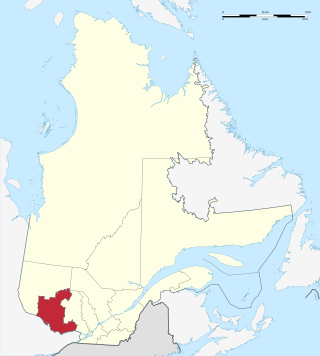
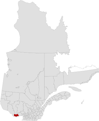
Outaouais is a region of western Quebec, Canada. It includes the city of Gatineau, the municipality of Val-des-Monts, the municipality of Cantley and the Papineau region. Geographically, it is located on the north side of the Ottawa River opposite Canada's capital, Ottawa. It has a land area of 30,467 square kilometres (11,763 sq mi) and its population was 404,265 inhabitants as of 2021.
Area codes 819, 873, and 468 are overlay telephone area codes in the North American Numbering Plan (NANP) for central and western Quebec, Canada, including the Quebec portion of the National Capital Region, and the Hudson Strait and Ungava Bay coastlines of Quebec. Major cities in the territory include Gatineau, Sherbrooke, Trois-Rivières, Drummondville, Shawinigan, Victoriaville, Rouyn-Noranda, Val-d'Or, Magog and Mont-Laurier.
Cantley is a rural municipality in Quebec, Canada, north of the city of Gatineau, east of the Gatineau River, located within Canada's National Capital Region approximately 17 km (11 mi) from Parliament Hill. Cantley is one of six municipalities within the Collines-de-l'Outaouais Regional County Municipality. Its roots are in farmland and mining, but recent housing projects since its creation in 1989 have resulted in a high rate of population growth. The population at the 2021 Canadian Census was 11,449, an increase of 7.0% from the 2016 population of 10,699. French is the first language of 86.7% of Cantley's residents.
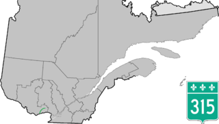
Route 315 is a road in the Canadian province of Quebec that connects the Gatineau sector of Masson-Angers to Namur. Initially, the road started in Buckingham on Rue Joseph at the city's Main Street just a few kilometres further north, but when A-50 was extended further east as a Buckingham by-pass at its current end at Doherty Road, the section of Route 309 between Buckingham and the junction at Route 148 in Masson-Angers was renumbered Route 315 while Route 309 starts at Doherty Road and A-50.

Val-des-Monts is a municipality in the Outaouais region of Quebec, Canada, located about 40 km (25 mi) north of Ottawa, Ontario. It has a population of 13,328 residents in 2021. Formed in 1975 by the merger of the towns of Perkins, Saint-Pierre-de-Wakefield and Poltimore, it consists mainly of farms and mountainous forests. Many of its residents commute to Ottawa or Gatineau for work. Due to its numerous lakes, its population is boosted during summers by people living in cottages. Most of the people in Val-des-Monts live in the village of Perkins.
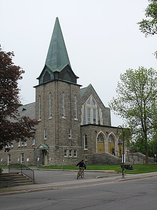
Boulevard Gréber is an important principal arterial road in Gatineau, Quebec. It runs from Montee Paiement to the Gatineau River. It is named after French urban planner Jacques Gréber. It was once part of Route 148 of the provincial network.
Rue Saint-Louis is a main street in Gatineau, Quebec, Canada, that runs mostly along the north and east side of the Gatineau River in the old city of Gatineau. It starts at the boundaries of the city of Gatineau and the suburban town of Cantley, Quebec and ends at Boulevard Maloney. On its northern end until Autoroute 50, it runs parallel to the Gatineau River, while it briefly runs parallel to the Ottawa River on its eastern end.
Boulevard Saint-Joseph is a commercial boulevard in the former city of Hull, Quebec. It runs from Boulevard Alexandre-Taché to the boundaries of the Gatineau and the suburban town of Chelsea.

Route 148 is an east-west highway in Quebec, Canada. It runs from junction of Autoroute 13 and Autoroute 440 in Laval in the Montreal region to the Ontario-Quebec border in L'Isle-aux-Allumettes in western Quebec. For most of its length, Route 148 follows the north shore of the Ottawa River where it acted as the principal route between communities in the Outaouais region until the completion of Autoroute 50 in 2012. At the Ontario-Quebec border in L'Isle-aux-Allumettes Route 148 continues into Ontario as Highway 148.

Route 105 is a north-south highway in Quebec, Canada. It runs from Hull, where it is known as Boulevard Saint-Joseph, to Grand-Remous where it ends at Route 117.

Route 117, the Trans Canada Highway Northern Route, is a provincial highway within the Canadian province of Quebec, running between Montreal and the Quebec/Ontario border where it continues as Highway 66 east of McGarry, Ontario. It is an important road since it is the only direct route between southern Quebec and the Abitibi-Témiscamingue region.

Route 335 is a north-south regional route located on the north shore of the St. Lawrence River. from Montreal It serves the administrative regions of Montreal, Laval, Laurentides, and Lanaudière. It is the only secondary road whose route crosses the Island of Montreal. Between Autoroute 440 in Laval and Côte-Saint-Louis Road in Terrebonne, Route 335 is located in the right-of-way of the future Autoroute 19.

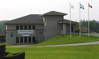
The Centre de services scolaire des Draveurs is one of 4 public Francophone school service centres operating in the Outaouais region, Quebec. The school board was created in 1986 in the old city of Gatineau about 15 years before amalgamation. The board is responsible for primary, secondary and adult schools located in the former city of Gatineau as well as in the municipalities of Val-des-Monts and Cantley located north of Gatineau. Its current president is Christine Emond-Lapointe, a former Bloc Québécois candidate for the riding of Pontiac in the 2006 Canadian federal elections. The general manager is Francois Jette.

Route 366 is a secondary highway in the Outaouais region of Quebec. It runs from Route 301 near Creemorne in the Pontiac to Route 148 in the city of Gatineau.

Route 309 is a provincial highway located in the Outaouais region in western Quebec. It starts at the junction of Autoroute 50 in the Buckingham sector, in the city of Gatineau's east end. It runs mostly parallel to the Du Lièvre River and ends north of Mont-Laurier in the town of Sainte-Anne-du-Lac in the Upper Laurentians.

Route 311 is a provincial highway located in the Laurentides region of Quebec. The 77 kilometer-highway runs from south to north from the junction of Route 309 in Notre-Dame-de-Pontmain to Mont-Saint-Michel also at the junction of Highway 309. It is briefly concurrent with Route 117 at Beaux-Rivages and Lac-des-Écorces.
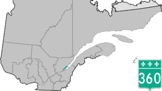
Route 360 is a provincial highway located in the Capitale-Nationale region in the south central part of the province of Quebec. The highway runs from Quebec City's Beauport sector and ends at the junction of Route 138 northeast of Saint-Tite-des-Caps in the Charlevoix region. For a large portion of its length it runs right beside Route 138, overlapping it briefly near Beaupré. The road also travels through significant portions of the Charlevoix touristic area and also crosses Mont-Sainte-Anne ski resort and the Montmorency Falls located at the Montmorency River which connects the Saint Lawrence River nearby.


