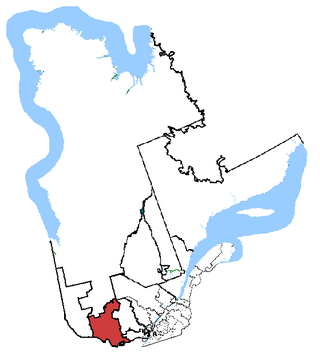
Pontiac is a federal electoral district in western Quebec, Canada, that has been represented in the House of Commons of Canada from 1867 to 1949 and since 1968.
Autoroute 5 is a short controlled-access Autoroute in the Outaouais region of western Quebec. It connects the central urban area of Gatineau with the recreational areas of Gatineau Park and the exurban rural areas of Chelsea and La Pêche. The southern terminus provides access to the Macdonald-Cartier Bridge, which continues into downtown Ottawa. The A-5 generally has four lanes of traffic with the exception of southernmost section across the Macdonald-Cartier Bridge where A-5 widens to six lanes.
Autoroute 50 is an Autoroute in western Quebec, Canada. It links Canada's National Capital Region (Gatineau) and the Greater Montreal area (Mirabel).
Boulevard Gréber is an important principal arterial road in Gatineau, Quebec. It runs from Montee Paiement to the Gatineau River. It is named after French urban planner Jacques Gréber. It was once part of Route 148 of the provincial network.
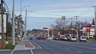
Boulevard Maloney is one of Gatineau's main commercial roads. It starts at Autoroute 50 via an incomplete interchange and ends at the boundary with the former city of Masson-Angers. It is also known as Route 148. However, one may notice a blue shield sign of the highway on the westbound lane at Boulevard Gréber even if it is not the highway itself as the western portion previous terminated at Maloney before more extensions towards Masson-Angers were made in 1986. Route 148 continues further east through Buckingham towards Laval. Prior to the construction of A-50, was the main roadway through the urban community towards Montreal, the Papineau region and the Laurentides.
Boulevard Saint-Joseph is a commercial boulevard in the former city of Hull, Quebec. It runs from Boulevard Alexandre-Taché to the boundaries of the Gatineau and the suburban town of Chelsea.

Boulevard Maisonneuve is an important arterial in the heart of downtown Gatineau, Quebec. It serves as connector route between the Portage Bridge from Ottawa to Quebec Autoroutes 5 and 50 as well as Boulevard Fournier towards the Gatineau sector of the city, northern portions of the Hull sector and the northern east suburbs. It also gives access to the Macdonald-Cartier Bridge and the Alexandra Bridge.

The Rapibus is a bus rapid transit system for the Société de Transport de l'Outaouais (STO) in the city of Gatineau, Quebec. Construction was completed in the summer of 2013 with service beginning in the fall. The Rapibus aims to speed up the service for commuters in growing sub-divisions in the northern and eastern areas of the city by alleviating the congestion on key arteries currently served by bus-designated lanes. A direct link to Ottawa is included.
Boulevard Alexandre-Taché is an east-west road located in the city of Gatineau, Quebec. It is named in honour of former member for the Hull electoral district, Alexandre Taché, who served for 15 years with the Union Nationale when the political party was in power under the leadership of Maurice Duplessis.

Boulevard des Allumettières is a major 13.7 km arterial road in Gatineau, Quebec, Canada, that connects Aylmer and Hull sectors of the city running from Eardley Road to the Alexandra Bridge towards Ottawa. It is the most recent east-west arterial connection from the West to the downtown core and construction of the entire length was completed during the fall of 2007.
Autoroute 740 is a Quebec Autoroute in metropolitan Quebec City, Canada. A spur route of Autoroute 40, the A-740 runs for 7.3 km (4.5 mi) on a north-south axis through the boroughs of Sainte-Foy–Sillery–Cap-Rouge and Les Rivières, with interchanges at the A-440 at exit 4 and the A-40 at exit 9.

Rue Laurier is a main street located in the heart of the City of Gatineau, Quebec. It starts at Rue Eddy and ends at Rue Dussault.
Boulevard du Plateau is a collector roadway located in Gatineau, Quebec, beside Route 148. The boulevard starts at Chemin Vanier in Aylmer and ends at Boulevard Saint-Raymond and Route 148.
Boulevard de la Cité-des-Jeunes is a major road in the city of Gatineau, Quebec. It begins on the northwestern outskirts of the city, where Chemin de la Mine becomes Boulevard de la Cité-des-Jeunes, and runs mainly to the southeast, along the eastern boundary of Gatineau Park. The Boulevard later becomes Promenade du Lac des Fees after meeting with Boulevard Saint-Raymond near the hospital. From the south end and travelling in the other direction, the roadway begins at Boulevard Saint-Joseph as two one-way streets, becomes Promenade du Lac des Fees followed by Boulevard de la Cité-des-Jeunes and chemin de la Mine, which ends at Chemin Notch inside Gatineau Park.
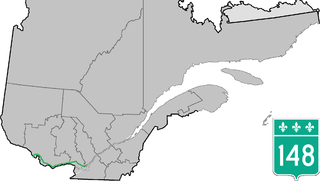
Route 148 is an east-west highway in Quebec, Canada. It runs from junction of Autoroute 13 and Autoroute 440 in Laval in the Montreal region to the Ontario-Quebec border in L'Isle-aux-Allumettes in western Quebec. For most of its length, Route 148 follows the north shore of the Ottawa River where it acted as the principal route between communities in the Outaouais region until the completion of Autoroute 50 in 2012. At the Ontario-Quebec border in L'Isle-aux-Allumettes Route 148 continues into Ontario as Highway 148.

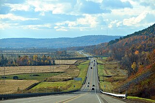
Route 117, the Trans Canada Highway Northern Route, is a provincial highway within the Canadian province of Quebec, running between Montreal and the Quebec/Ontario border where it continues as Highway 66 east of McGarry, Ontario. It is an important road since it is the only direct route between southern Quebec and the Abitibi-Témiscamingue region.
The Centre de services scolaire des Portages-de-l'Outaouais (CSSPO) is one of 4 public school service centres operating in the Outaouais, Quebec.
Le Plateau is a neighbourhood and an urban village in Gatineau, located west of downtown Hull. The neighbourhood is limited to Gatineau Park to the north, chemin Vanier to the west, Boulevard Saint-Raymond to the east and Boulevard des Allumettières to the south. It consists mostly of houses, but many shopping centres find their home at Plateau.
