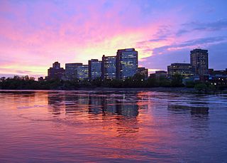
Hull is the central business district and oldest neighbourhood of the city of Gatineau, Quebec, Canada. It is located on the west bank of the Gatineau River and the north shore of the Ottawa River, directly opposite Ottawa. As part of Canada's National Capital Region, it contains offices for more than 20,000 civil servants. It was named after Kingston upon Hull in England.
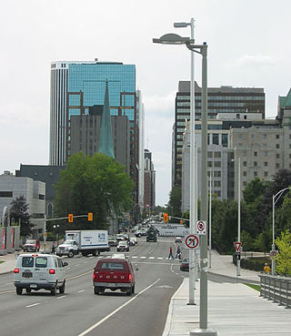
Laurier Avenue is a central east west street running through Ottawa, Ontario, Canada. Originally known as "Maria Street" and "Theodore Street", it was renamed in honour of Canadian Prime Minister Sir Wilfrid Laurier. Laurier House, the residence of Prime Ministers Laurier and William Lyon Mackenzie King, is located at the corner of Laurier Avenue East and Chapel Street.

The National Capital Region (NCR), also known as Canada's Capital Region and Ottawa–Gatineau, is an official federal designation encompassing the Canadian capital of Ottawa, Ontario, the adjacent city of Gatineau, Quebec, and surrounding suburban and exurban areas. Despite its designation, the NCR is not a separate political or administrative entity and falls within the provinces of Ontario and Quebec.
Autoroute 5 is a short controlled-access Autoroute in the Outaouais region of western Quebec. It connects the central urban area of Gatineau with the recreational areas of Gatineau Park and the exurban rural areas of Chelsea and La Pêche. The southern terminus provides access to the Macdonald-Cartier Bridge, which continues into downtown Ottawa. The A-5 generally has four lanes of traffic with the exception of southernmost section across the Macdonald-Cartier Bridge where A-5 widens to six lanes.

The Chaudière Falls, also known as the Kana:tso or Akikodjiwan Falls, are a set of cascades and waterfall in the centre of the Ottawa-Gatineau metropolitan area in Canada where the Ottawa River narrows between a rocky escarpment on both sides of the river. The location is just west of the Chaudière Bridge and Booth-Eddy streets corridor, northwest of the Canadian War Museum at LeBreton Flats and adjacent to the historic industrial E. B. Eddy complex. The islands surrounding the Chaudière Falls, counter-clockwise, are Chaudière Island, Albert Island, little Coffin Island was just south of Albert Island but is now submerged, Victoria Island and Amelia Island,, Philemon Island was originally called the Peninsular Village by the Wrights but became an island when the timber slide was built in 1829 it is now fused to south shore of City of Gatineau, and Russell Island, now submerged, was at the head of the Falls before the Ring dam was built. The falls are about 60 metres (200 ft) wide and drop 15 metres (49 ft). The area around the falls was once heavily industrialized, especially in the 19th century, driving growth of the surrounding cities.
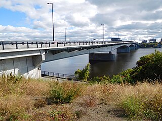
The Macdonald-Cartier Bridge is a bridge connecting Ottawa, Ontario, to Gatineau, Quebec. The bridge is a 618 m long continuous steel box girder bridge and carries six lanes of traffic. It links King Edward Avenue and Sussex Drive in Ottawa with Autoroute 5 in Quebec. It is the easternmost bridge linking Ottawa to Gatineau, running just east of the Alexandra Bridge.
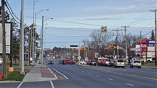
Boulevard Maloney is one of Gatineau's main commercial roads. It starts at Autoroute 50 via an incomplete interchange and ends at the boundary with the former city of Masson-Angers. It is also known as Route 148. However, one may notice a blue shield sign of the highway on the westbound lane at Boulevard Gréber even if it is not the highway itself as the western portion previous terminated at Maloney before more extensions towards Masson-Angers were made in 1986. Route 148 continues further east through Buckingham towards Laval. Prior to the construction of A-50, was the main roadway through the urban community towards Montreal, the Papineau region and the Laurentides.
Rue Saint-Louis is a main street in Gatineau, Quebec, Canada, that runs mostly along the north and east side of the Gatineau River in the old city of Gatineau. It starts at the boundaries of the city of Gatineau and the suburban town of Cantley, Quebec and ends at Boulevard Maloney. On its northern end until Autoroute 50, it runs parallel to the Gatineau River, while it briefly runs parallel to the Ottawa River on its eastern end.
Boulevard Saint-Joseph is a commercial boulevard in the former city of Hull, Quebec. It runs from Boulevard Alexandre-Taché to the boundaries of the Gatineau and the suburban town of Chelsea.

Boulevard Maisonneuve is an important arterial in the heart of downtown Gatineau, Quebec. It serves as connector route between the Portage Bridge from Ottawa to Quebec Autoroutes 5 and 50 as well as Boulevard Fournier towards the Gatineau sector of the city, northern portions of the Hull sector and the northern east suburbs. It also gives access to the Macdonald-Cartier Bridge and the Alexandra Bridge.
Boulevard Alexandre-Taché is an east-west road located in the city of Gatineau, Quebec. It is named in honour of former member for the Hull electoral district, Alexandre Taché, who served for 15 years with the Union Nationale when the political party was in power under the leadership of Maurice Duplessis.

Boulevard des Allumettières is a major 13.7 km arterial road in Gatineau, Quebec, Canada, that connects Aylmer and Hull sectors of the city running from Eardley Road to the Alexandra Bridge towards Ottawa. It is the most recent east-west arterial connection from the West to the downtown core and construction of the entire length was completed during the fall of 2007.
Boulevard Fournier is a main route in the city of Gatineau, Quebec that connects the Gatineau and Hull sectors. It starts as the extension of Boulevard Greber in the old city of Gatineau and ends at the entrance of the downtown core where it becomes Boulevard Maisonneuve which connects the Portage Bridge towards Ottawa. It was once part of Route 148 until the Quebec Ministry of Transportation rerouted the provincial highway onto Autoroute 50 and Autoroute 5 as a concurrency.

Route 117, the Trans Canada Highway Northern Route, is a provincial highway within the Canadian province of Quebec, running between Montreal and the Quebec/Ontario border where it continues as Highway 66 east of McGarry, Ontario. It is an important road since it is the only direct route between southern Quebec and the Abitibi-Témiscamingue region.

The Portage Bridge crosses the Ottawa River just down-river from the Chaudière Bridge, joining the communities of Gatineau, Quebec and Ottawa, Ontario. It links Laurier Street and Alexandre-Taché Boulevard in the Hull sector of Gatineau and Wellington Street at the Garden of the Provinces and Territories in Ottawa, crossing Victoria Island and the former Philemon Island on the way.

King Edward Avenue is a major thoroughfare in the eastern part of Ottawa, Ontario, Canada. Despite being a municipal road, a portion of the street is designated as part of Canada's National Highway System, as part of an interconnecting route between Ontario Highway 417 in Ottawa and Quebec Autoroute 5 in Gatineau.
Café Henry Burger was a restaurant in Gatineau, Quebec, near Ottawa.
