
Pontiac is a federal electoral district in western Quebec, Canada, that has been represented in the House of Commons of Canada from 1867 to 1949 and since 1968.
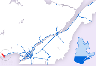
Autoroute 5 is a short Autoroute in the Outaouais region of western Quebec. It connects the central urban area of Gatineau with the recreational areas of Gatineau Park and the exurban rural areas of Chelsea and La Pêche. The southern terminus provides access to the Macdonald-Cartier Bridge, which continues into downtown Ottawa. The A-5 generally has four lanes of traffic with the exception of southernmost section across the Macdonald-Cartier Bridge where A-5 widens to six lanes.

Autoroute 50 is an Autoroute in western Quebec, Canada. It links Canada's National Capital Region (Gatineau) and the Greater Montreal area (Mirabel).
Boulevard Gréber is an important principal arterial road in Gatineau, Quebec. It runs from Montee Paiement to the Gatineau River. It is named after French urban planner Jacques Gréber. It was once part of Route 148 of the provincial network.
Rue Saint-Louis is a main street in Gatineau, Quebec, Canada, that runs mostly along the north and east side of the Gatineau River in the old city of Gatineau. It starts at the boundaries of the city of Gatineau and the suburban town of Cantley, Quebec and ends at Boulevard Maloney. On its northern end until Autoroute 50, it runs parallel to the Gatineau River, while it briefly runs parallel to the Ottawa River on its eastern end.
Boulevard Saint-Joseph is a commercial boulevard in the former city of Hull, Quebec. It runs from Boulevard Alexandre-Taché to the boundaries of the Gatineau and the suburban town of Chelsea.

Boulevard Maisonneuve is an important arterial in the heart of Downtown Gatineau, Quebec. It serves as connector route between the Portage Bridge from Ottawa to Quebec Autoroutes 5 and 50 as well as Boulevard Fournier towards the Gatineau sector of the city, northern portions of the Hull sector and the northern east suburbs. It also gives access to the Macdonald-Cartier Bridge and the Alexandra Bridge.

The Rapibus is a bus rapid transit system for the Société de Transport de l'Outaouais (STO) in the city of Gatineau, Quebec. Construction was completed in the summer of 2013 with service beginning in the fall. The Rapibus aims to speed up the service for commuters in growing sub-divisions in the northern and eastern areas of the city by alleviating the congestion on key arteries currently served by bus-designated lanes. A direct link to Ottawa is included.

Boulevard des Allumettières is a major 13.7 km arterial road in Gatineau, Quebec, Canada, that connects Aylmer and Hull sectors of the city running from Eardley Road to the Alexandra Bridge towards Ottawa. It is the most recent east-west arterial connection from the West to the downtown core and construction of the entire length was completed during the fall of 2007.
Boulevard Fournier is a main route in the city of Gatineau, Quebec that connects the Gatineau and Hull sectors. It starts as the extension of Boulevard Greber in the old city of Gatineau and ends at the entrance of the downtown core where it becomes Boulevard Maisonneuve which connects the Portage Bridge towards Ottawa. It was once part of Route 148 until the Quebec Ministry of Transportation rerouted the provincial highway onto Autoroute 50 and Autoroute 5 as a concurrency.
Boulevard Saint-Raymond is a major boulevard located in Gatineau, Quebec. It starts at Boulevard Saint-Joseph and ends at Boulevard Alexandre-Tache just west of the limits between the Hull and Aylmer sectors. Before 2003, it ended at Chemin Pink but since then it includes the former section of Chemin de la Montagne Sud.
Boulevard de la Cité-des-Jeunes is a major road in the city of Gatineau, Quebec. It begins on the northwestern outskirts of the city, where Chemin de la Mine becomes Boulevard de la Cité-des-Jeunes, and runs mainly to the southeast, along the eastern boundary of Gatineau Park. The Boulevard later becomes Promenade du Lac des Fees after meeting with Boulevard Saint-Raymond near the hospital. From the south end and travelling in the other direction, the roadway begins at Boulevard Saint-Joseph as two one-way streets, becomes Promenade du Lac des Fees followed by Boulevard de la Cité-des-Jeunes and chemin de la Mine, which ends at Chemin Notch inside Gatineau Park.

Route 148 is an east-west highway in Quebec, Canada. It runs from junction of Autoroute 13 and Autoroute 440 in Laval in the Montreal region to the Ontario-Quebec border in L'Isle-aux-Allumettes in western Quebec. For most of its length, Route 148 follows the north shore of the Ottawa River where it acted as the principal route between communities in the Outaouais region until the completion of Autoroute 50 in 2012. At the Ontario-Quebec border in L'Isle-aux-Allumettes Route 148 continues into Ontario as Highway 148.

Route 117, the Trans Canada Highway Northern Route, is a provincial highway within the Canadian province of Quebec, running between Montreal and the Quebec/Ontario border where it continues as Highway 66 east of McGarry, Ontario. It is an important road since it is the only direct route between southern Quebec and the Abitibi-Témiscamingue region.
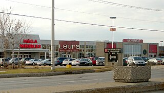
Les Promenades Gatineau is a major shopping centre located in Canada's National Capital Region in the city of Gatineau, Quebec. The mall is the intersection of Gréber and Maloney Boulevards, one of the city's busiest intersections, and is just off Autoroute 50. It is the city's largest shopping mall by retail space and by shoppers.

List of neighbourhoods in the City of Gatineau, Quebec, Canada.
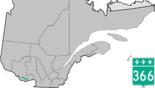
Route 366 is a secondary highway in the Outaouais region of Quebec. It runs from Route 301 near Creemorne in the Pontiac to Route 148 in the city of Gatineau.

Route 307 is a provincial road located in the Outaouais region of Quebec. The road runs mostly parallel to the Gatineau River on the eastern side of it. It starts at the corner of Rue Saint-Louis and Boulevard Greber in the Gatineau sector of the city of Gatineau. It runs north of Gatineau and ends in Val-des-Bois at the junction of Route 309 which runs from the Buckingham sector north into the Upper Laurentians.

Route 309 is a provincial highway located in the Outaouais region in western Quebec. It starts at the junction of Autoroute 50 in the Buckingham sector, in the city of Gatineau's east end. It runs mostly parallel to the Du Lièvre River and ends north of Mont-Laurier in the town of Sainte-Anne-du-Lac in the Upper Laurentians.

