A374 road

Last updated

UK road A374.svg
A374
Route information
Length16.5 mi (26.6 km)
Major junctions
East end Plymouth
50°23′28″N4°05′14″W / 50.3910°N 4.0871°W / 50.3910; -4.0871 (A374 road (eastern end))
Major intersectionsUK road A38.svg A38
UK road A379.svg A379
UK road A386.svg A386
UK road A387.svg A387
West end Trerulefoot
50°24′24″N4°21′04″W / 50.4068°N 4.3511°W / 50.4068; -4.3511 (A374 road (western end))
Location
Country United Kingdom
Constituent country England
Road network

The A374 is a main road in the United Kingdom, one of six A-roads making the border crossing between Devon and Cornwall. It is the most southerly of the A37x group of roads, starting and ending its journey with the A38 trunk road, from the outskirts of Plymouth in Devon to the Trerulefoot roundabout in Cornwall.

Contents

Route

The A374 in Plymouth The A374 into Plymouth - geograph.org.uk - 935996.jpg
The A374 in Plymouth
Torpoint Ferry, the A374 crossing over the River Tamar TorpointFerryNew.jpg
Torpoint Ferry, the A374 crossing over the River Tamar
The Halfway House, Polbathic Halfway House Pub on A374 - geograph.org.uk - 342931.jpg
The Halfway House, Polbathic

Starting at the Marsh Mills junction of the A38, the A374 heads west into Plymouth, following the course of the River Plym along a section of dual carriageway. At Prince Rock the A379 merges from Plymstock and continues into the city. On the edge of the city centre it meets the Charles Cross roundabout, in the middle of which stands the preserved shell of the derelict Charles Church. Skirting the Plymouth city centre to the north, the A374 continues past the main buildings of the University of Plymouth and is met by the A386 near Plymouth railway station. Going westward down the locally notorious Union Street, the road enters Devonport and comes to the River Tamar. [1]

The A374 continues on into Cornwall, across the river, via the vehicle carrying Torpoint Ferry. Through the town of Torpoint the road continues, following the River Lynher, through the villages of Antony and Sheviock and on to Polbathic, where the B3249 starts northwards to join the A38, avoiding a low bridge at Trerulefoot roundabout. The A374 climbs further through agricultural land, with the A387 joining from the west, and ends at Trerulefoot roundabout, re-joining the A38. [1]

History

The original road designated as the A374, as of 1922, ran from Horton Cross, just north of Donyatt in Somerset, southwards to Colyford in Devon along the route of what is now the A358. [2] Whereas the Plymouth-Torpoint-Trerulefoot road (current A374) was designated as part of the A389 road to Bodmin in Cornwall at this time. [3]

After the phases of road re-classification carried out in the 1920s and 1930s, the Trerulefoot-Torpoint-Marsh Mills stretch of road formed part of the A38, as the Torpoint Ferry was the main route across the River Tamar. After the Tamar Bridge opened in 1961 the A38 was re-designated through Tideford, on what was previously the route of the A374 and the current route of the A374 was numbered as such.

The current A374 also used to extend beyond Marsh Mills through Plympton to its southwestern edge, taking the previous route of the A38 prior to the Plympton bypass. However this has now been downgraded to the B3416 and other unclassified roads within Plympton town centre.

The A374 from Torpoint to Trerulefoot is also a very highly prized road in the motorcycling fraternity. Known locally as the "Torpoint Twisties" it offers a challenge to all with its series of bends and straights. However it also causes controversy because of the number of accidents and fatalities which occur, meaning the road has been classed as a "red" status road by the local constabulary and is patrolled regularly and monitored by static speed cameras. [4]

Related Research Articles

<span class="mw-page-title-main">Hamoaze</span> Section of the River Tamar in southwest England

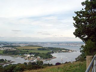
The Hamoaze is an estuarine stretch of the tidal River Tamar, between its confluence with the River Lynher and Plymouth Sound, England.

<span class="mw-page-title-main">Torpoint Ferry</span>

The Torpoint Ferry is a car and pedestrian chain ferry connecting the A374 which crosses the Hamoaze, a stretch of water at the mouth of the River Tamar, between Devonport in Plymouth and Torpoint in Cornwall. The service was established in 1791 and chain ferry operations were introduced by James Meadows Rendel in 1832.

<span class="mw-page-title-main">Tamar Bridge</span> Suspension bridge in southwest England

The Tamar Bridge is a suspension bridge over the River Tamar between Saltash, Cornwall and Plymouth, Devon in southwest England. It is 335 metres (1,099 ft) long, running adjacent the Royal Albert Bridge, and part of the A38, a main road between the two counties.

<span class="mw-page-title-main">River Tamar</span> River in southwest England

The Tamar is a river in south west England, that forms most of the border between Devon and Cornwall. A part of the Tamar Valley is a World Heritage Site due to its historic mining activities.

<span class="mw-page-title-main">A38 road</span> Trunk road in England

The A38, parts of which are known as Devon Expressway, Bristol Road and Gloucester Road, is a major A-class trunk road in England.

<span class="mw-page-title-main">Torpoint</span> Town in Cornwall, England

Torpoint is a civil parish and town on the Rame Peninsula in southeast Cornwall, England, United Kingdom. It is situated opposite the city of Plymouth across the Hamoaze which is the tidal estuary of the River Tamar. Torpoint had a population of 8,457 at the 2001 census, decreasing to 8,364 at the 2011 census. Two electoral wards also exist. Their combined populations at the same census were 7,717.

<span class="mw-page-title-main">Saltash</span> Town in Cornwall, England

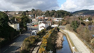
Saltash is a town and civil parish in south Cornwall, England, United Kingdom. It had a population of 16,184 in 2011 census. Saltash faces the city of Plymouth over the River Tamar and is popularly known as "the Gateway to Cornwall". Saltash’s landmarks include the Tamar Bridge which connects Plymouth to Cornwall by road, and the Royal Albert Bridge. The area of Latchbrook is part of the town.

Saltash Passage is on the Devon side of the River Tamar, opposite Saltash. It is part of St Budeaux, an area of Plymouth in Devon. Saltash Passage lies at the northern end of Wolseley Road, previously known as Ferry Road. The local railway station continues to be known as Ferry Road Station. Saltash Passage is named after the ferry route that carried passengers and vehicles between Saltash in Cornwall and Plymouth, across the River Tamar. The ferry became uneconomic following the construction of the Tamar Bridge in 1961. Saltash Passage is a popular leisure destination for the locals as well as tourists in summer.

<span class="mw-page-title-main">Devonport railway station</span> Railway station in Devon, England

Devonport railway station serves the Devonport area of Plymouth in Devon, England. It is 247 miles 15 chains (397.8 km) from London Paddington via Bristol Temple Meads. It is managed by Great Western Railway.

<span class="mw-page-title-main">St Budeaux Victoria Road railway station</span> Railway station in Devon, England

St Budeaux Victoria Road railway station is a suburban station in St Budeaux, Plymouth, Devon, England. The station is managed and served by Great Western Railway.

<span class="mw-page-title-main">Cornwall Railway</span> Former railway company in southwestern England

The Cornwall Railway was a 7 ft 14 in broad gauge railway from Plymouth in Devon to Falmouth in Cornwall, England, built in the second half of the nineteenth century. It was constantly beset with shortage of capital for the construction, and was eventually forced to sell its line to the dominant Great Western Railway.

<span class="mw-page-title-main">A379 road</span> Road in Devon, England

The A379 is a road in the English county of Devon. It links points on the edges of that county's two principal cities, Exeter and Plymouth, by an indirect and largely coastal route. The A38 provides a faster and more direct inland route between Exeter and Plymouth, whilst the A380 provides a similarly faster route between Exeter and the Torbay area. However the A379 serves many small coastal communities and ports along the coast. The indented nature of the South Devon coast means that the road is usually out of sight of the sea, but the many rivers and estuaries are crossed by bridges and, in one case, a cable ferry.

<span class="mw-page-title-main">Forgotten Corner of Cornwall</span> Geographical area of South East Cornwall, England

The Forgotten Corner of Cornwall is a geographical area of South East Cornwall, Great Britain. It includes the Rame Peninsula and the town of Torpoint, as well as villages like Antony, Downderry, Polbathic, Portwrinkle and Widegates.

<span class="mw-page-title-main">B roads in Zone 3 of the Great Britain numbering scheme</span>

B roads are numbered routes in Great Britain of lesser importance than A roads. See the article Great Britain road numbering scheme for the rationale behind the numbers allocated.

<span class="mw-page-title-main">Transport in Cornwall</span>

The evolution of transport in Cornwall has been shaped by the county's strong maritime, mining and industrial traditions and much of the transport infrastructure reflects this heritage.

<span class="mw-page-title-main">Railways in Plymouth</span> Overview of railways in Plymouth, Devon, England

The network of railways in Plymouth, Devon, England, was developed by companies affiliated to two competing railways, the Great Western Railway and the London and South Western Railway. At their height two main lines and three branch lines served 28 stations in the Plymouth area, but today just six stations remain in use.

The A38 is a major trunk road running from the south-east of Bodmin in Cornwall to Mansfield in Nottinghamshire. At 292 miles (470 km), it is the longest 'A' road entirely within England.

<span class="mw-page-title-main">Cremyll Ferry</span>

The Cremyll ferry is a foot passenger ferry across the Hamoaze from Admirals Hard in Stonehouse, Plymouth, Devon to Cremyll in Cornwall. It is operated by Plymouth boat Trips, and runs approximately every 30 minutes, with a 8-minute crossing time.

Devon League 2 was an English level ten rugby union league for clubs based in Devon; with one exception. The champions and runners-up are promoted to Devon League 1, and since the cancellation of Devon League 3 in 2003 there was no relegation as this is the lowest division in club rugby union within Devon.

References

  1. 1 2 Ordnance Survey: Landranger map sheet 201 Plymouth & Launceston ISBN   978-0-319-23146-3
  2. "A358". SABRE. Retrieved 25 March 2009.
  3. "1922 Road List". SABRE. Retrieved 25 March 2009.
  4. "Speed detection on the Torpoint Twisties". Devon & Cornwall Safety Camera Partnership. 9 October 2008. Retrieved 11 January 2010.
Map all coordinates using: OpenStreetMap  
Download coordinates as: KML

Coordinates: 50°22′25″N4°14′22″W / 50.3737°N 4.2394°W / 50.3737; -4.2394 (A374 road)