
A gunnies, gunnis, or gunniss is the space left in a mine after the extraction by stoping of a vertical or near vertical ore-bearing lode. The term is also used when this space breaks the surface of the ground, but it can then be known as a coffin or goffen. It can also be used to describe the deep trenches that were dug by early miners in following the ore-bearing lode downwards from the surface – in this case they are often called open-works; their existence can provide the earliest evidence of mining in an area. William Pryce, writing in 1778, also used the term as a measure of width, a single gunnies being equal to three feet.
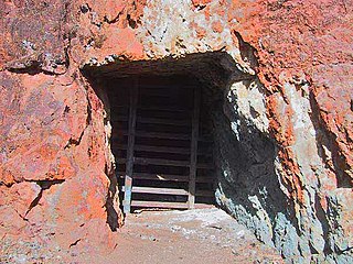
An adit is an entrance to an underground mine which is horizontal or nearly horizontal, by which the mine can be entered, drained of water, ventilated, and minerals extracted at the lowest convenient level. Adits are also used to explore for mineral veins.

Mount Wellington Tin mine, two miles east of the village of St Day in Cornwall, in the United Kingdom, opened in 1976 and was the first new mine in the region in many years.

Geevor Tin Mine, formerly North Levant Mine is a tin mine in the far west of Cornwall, United Kingdom, between the villages of Pendeen and Trewellard. It was operational between 1911 and 1990 during which time it produced about 50,000 tons of black tin. It is now a museum and heritage centre left as a living history of a working tin mine. The museum is an Anchor Point of ERIH, The European Route of Industrial Heritage. Since 2006, the mine has been part of the UNESCO World Heritage Site Cornwall and West Devon Mining Landscape.

Poldice mine is a former metalliferous mine located in Poldice Valley in southwest Cornwall, England, United Kingdom. It is situated near the hamlet of Todpool, between the villages of Twelveheads and St Day, three miles (5 km) east of Redruth.

Perranarworthal is a civil parish and village in Cornwall, England, United Kingdom. The village is about four miles (6.5 km) northwest of Falmouth and five miles (8 km) southwest of Truro. Perranarworthal parish is bordered on the north by Kea parish, on the east by Restronguet Creek and Mylor parish, on the south by St Gluvias and Stithians parishes and on the west by Gwennap parish. The parish population at the 2011 census was 1,496. The name derives from the Manor of Arworthal which has had a number of spellings in the past including Hareworthal (1187), Arwoethel and Arwythel. By the 18th-century two names appear on maps "Perran Arworthal" meaning St Piran's by the creek or estuary. William Penaluna described the settlement in 1838. Perranwell railway station is on the Maritime Line.

Gwennap is a village and civil parish in Cornwall, England. It is about five miles (8 km) southeast of Redruth. Hamlets of Burncoose, Comford, Coombe, Crofthandy, Cusgarne, Fernsplatt, Frogpool, Goon Gumpas Hick's Mill, Tresamble and United Downs lie in the parish, as does Little Beside country house.

Wheal Jane is a disused tin mine near Baldhu and Chacewater in West Cornwall, England, United Kingdom. The area itself consisted of a large number of mines.
The Redruth and Chasewater Railway,, was an early mineral railway line in Cornwall, England, UK. It opened in 1825 and was built to convey the output from copper mines in the Gwennap area to wharves on Restronguet Creek around Devoran, and to bring in coal to fuel mine engines; later it carried timber for pit props and also house coal.
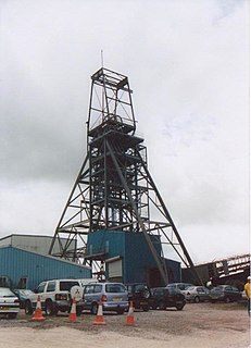
South Crofty is a metalliferous tin and copper mine located in the village of Pool, Cornwall, United Kingdom. An ancient mine, it has seen production for over 400 years, and extends almost two and a half miles across and 3,000 feet (910 m) down and has mined over 40 lodes. Evidence of mining activity in South Crofty has been dated back to 1592, with full-scale mining beginning in the mid-17th century. The mine went into serious decline after 1985 and eventually closed in 1998. An effort to reopen the mine under new management is still underway as of October 2017.

Devoran is a village in south Cornwall, England, United Kingdom. It is 4 miles (6.4 km) southwest of Truro at grid reference SW 793 392. Formerly an ecclesiastical parish, Devoran is now in the civil parish of Feock.

Wheal Peevor was a metalliferous mine located on North Downs about 1.5 miles north-east of Redruth, Cornwall, England. The first mining sett was granted here in around 1701 on land owned by the St Aubyn family. It was originally mined at shallow depths for copper, but when the price for that metal slumped after 1788, the mine was able to change to mining tin ore, which was found deeper down. In the late 18th century Wheal Peevor had the advantage of being drained by the Great County Adit which was around 100 metres deep here. The mine covered only 12 acres but had rich tin lodes. In addition to tin and copper, pyrite was also mined here between 1872 and 1887.

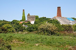
Wheal Gorland was a metalliferous mine located just to the north-east of the village of St Day, Cornwall, in England, United Kingdom. It was one of the most important Cornish mines of the late 18th and early 19th centuries, both for the quantity of ore it produced and for the wide variety of uncommon secondary copper minerals found there as a result of supergene enrichment. It is the type locality for the minerals chenevixite, clinoclase, cornwallite, kernowite and liroconite.
Wheal Busy, sometimes called Great Wheal Busy and in its early years known as Chacewater Mine, was a metalliferous mine halfway between Redruth and Truro in the Gwennap mining area of Cornwall, England. During the 18th century the mine produced enormous amounts of copper ore and was very wealthy, but from the later 19th century onwards was not profitable. Today the site of the mine is part of the Cornwall and West Devon Mining Landscape World Heritage Site.

Consolidated Mines, also known as Great Consolidated mine, but most commonly called Consols or Great Consols was a metalliferous mine about a mile ESE of the village of St Day, Cornwall, England. Mainly active during the first half of the 19th century, its mining sett was about 600 yards north–south; and 2,700 yards east–west, to the east of Carharrack. Although always much troubled by underground water, the mine was at times highly profitable, and it was the largest single producer of copper ore in Cornwall. Today the mine is part of the Cornwall and West Devon Mining Landscape World Heritage Site.

Restronguet Creek is a tidal ria in south Cornwall, United Kingdom. It is a tributary of Carrick Roads, the estuary of the River Fal, and is situated approximately four miles (6.5 km) south of Truro and three miles (5 km) north of Falmouth.

The Carnon viaduct carries a railway line from Truro to Falmouth – now branded the Maritime Line – over the valley of the Carnon River in west Cornwall, United Kingdom. The viaduct is situated half-a-mile northeast of Perranwell station which is five miles (8 km) from the line's terminus at Falmouth and three miles (5 km) from its junction with the Cornish main line at Truro.
The Portreath Tramroad, or alternatively the Portreath Tramway was opened in 1815, providing a wagonway route from mines near Scorrier in Cornwall, England, to a port at Portreath. From there, it could be transported to market by coastal shipping. It was later extended to serve the Poldice mine near St Day, and became known as the Poldice Tramroad, or Poldice Tramway.

The Carnon River is a heavily polluted river in Cornwall, England. It starts in Chacewater. Trewedna Water and River Kennall flow into the Carnon before it merges with Tallack's Creek to become Restronguet Creek, which eventually flows into the English Channel at the mouth of Carrick Roads.

Carnon Mine was a tin mine at Restronguet Creek, near the village of Devoran in Cornwall, England. A ruined engine house survives on the north bank of the creek. It is a Grade II listed building.
