
Land's End is a headland and tourist and holiday complex in western Cornwall, England, on the Penwith peninsula about eight miles (13 km) west-south-west of Penzance at the western end of the A30 road. To the east of it is the English Channel, and to the west the Celtic Sea.

The Tidal River is a perennial river of the West Gippsland catchment, located in the Wilsons Promontory region of the Australian state of Victoria. A permanent camping ground which the river flows passed to the south is also called Tidal River.

Wilsons Promontory Lighthouse is situated on South East Point, Wilsons Promontory, Victoria, Australia. From its point on the peninsula, it commands almost 360° views of Bass Strait. The Wilson's Promontory lighthouse is the southernmost lighthouse on mainland Australia, and is approximately 18 kilometres (11 mi) from the nearest town, Tidal River. Dormitory-style accommodation is available in the lighthouse.

South Hams is a local government district on the south coast of Devon, England. Services divide between those provided by its own Council headquartered in Totnes, and those provided by Devon County Council headquartered in the city of Exeter.

Cape Point is a promontory at the southeast corner of the Cape Peninsula, a mountainous and scenic landform that runs north-south for about thirty kilometres at the extreme southwestern tip of the African continent in South Africa. Table Mountain and the city of Cape Town are close to the northern extremity of the same peninsula. The cape is located at 34°21′26″S18°29′51″E, about 2.3 kilometres (1.4 mi) east and a little north of the Cape of Good Hope on the southwest corner. Although these two rocky capes are very well known, neither cape is actually the southernmost point of the mainland of Africa; that is Cape Agulhas, approximately 150 kilometres (93 mi) to the east-southeast.

Cabo da Roca or Cape Roca is a cape which forms the westernmost point of the Sintra Mountain Range, of mainland Portugal, of continental Europe, and of the Eurasian landmass. It is situated in the municipality of Sintra, near Azóia, in the southwest of the Lisbon District. Notably the point includes a lighthouse that started operation in 1772.
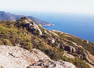
Wilsons Promontory, also known as Yiruk and Wamoon in the Gunai and Boonwurrung languages respectively, is a peninsula that forms the southernmost part of the Australian mainland, located in the state of Victoria.

Godrevy is an area on the eastern side of St Ives Bay, west Cornwall, England, United Kingdom, which faces the Atlantic Ocean. It is popular with both the surfing community and walkers. It is part owned by the National Trust, and offshore on Godrevy Island is a lighthouse maintained by Trinity House which is said to be the inspiration for Virginia Woolf's novel To the Lighthouse. Godrevy lies within the Cornwall Area of Outstanding Natural Beauty (AONB) and the South West Coast Path runs around the whole promontory. There are several public car parks on the western side where the National Trust owns and operates a café.

South West Rocks is a town located on the Mid North Coast of New South Wales, Australia, near the mouth of the Macleay River. It is approximately 40 km (25 mi) from Kempsey. Jerseyville is located nearby.

The Cliffy Island Lighthouse is located atop Cliffy Island, a steep-sided island which is the summit of a granite submarine mountain in the Bass Strait. Cliffy Island is located about 32 kilometres directly south of Port Albert, and roughly 38 kilometres to the northeast of Wilsons Promontory Lighthouse in Victoria, Australia. The lighthouse warns approaching vessels of rocks in Bass Strait by emitting a flash of white light every five seconds. The focal plane of the lightsource and Fresnel lens is situated 52 metres above sea level. The site is managed by the Victoria Department of Conservation and Natural Resources, while the lighthouse itself is operated by the Australian Maritime Safety Authority (AMSA). The island is accessible only by helicopter, and the entire site is closed to the public.

Smoky Cape is a headland in Australia on the New South Wales Mid-North Coast. It lies just east of the town of South West Rocks, and within the Hat Head National Park.

Hartland Point is a 325 ft (99 m) high rocky outcrop of land on the north-western tip of the Devon coast in England. It is three miles (5 km) north-west of the village of Hartland. The point marks the western limit of the Bristol Channel with the Atlantic Ocean continuing to the west. This location was known to the Romans as the "promontory of Hercules".

Prawle Point is a coastal headland in south Devon, England. It is the southernmost point of Devon. Just to the west is Elender Cove, and further west are Gammons Head Beach, also known as Maceley Cove, and Gammon Head.
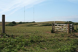
The Start Point transmitting station is a broadcasting facility at Start Point, Devon, owned by Arqiva. The site is just north-west of the Start Point lighthouse.

Capo Passero or Cape Passaro is a celebrated promontory of Sicily, forming the extreme southeastern point of the whole island, and one of the three promontories which were supposed to have given to it the name of "Trinacria."
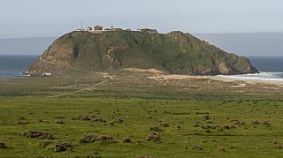
Point Sur State Historic Park is a California State Park on the Big Sur coastline of Monterey County, California, United States, 19 miles (31 km) south of Rio Road in Carmel. The 1889 Point Sur Lighthouse is on the National Register of Historic Places.
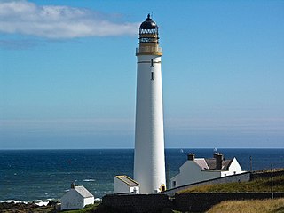
Scurdie Ness is a headland located on the South side of the River South Esk estuary, Montrose, Angus, Scotland. The River leads from the North Sea into Montrose Harbour and then into Montrose Basin. The headland has also been referred to as Scurdy Ness, Montrose point or Montroseness. The word Scurdie is a local word for the volcanic rock found there and Ness means a promontory, cape or headland. The coastline from Scurdie Ness to Rickle Craig has been designated a Site of Special Scientific Interest.

The Western Rocks are a group of uninhabited skerries and rocks in the south–western part of the Isles of Scilly, United Kingdom, and are renowned for the numerous shipwrecks in the area and the nearby Bishop Rock lighthouse. In 1971, the rocks and islands were designated a Site of Special Scientific Interest for their breeding sea birds. Landing on the islands is both difficult and discouraged and there are few published records of visits by naturalists.

Hammeren is a protected area and promontory in Denmark on the northernmost point of Bornholm island. It projects into Sæne Bugt bay in the Baltic Sea. The area includes Hammersø, the largest lake on the island and the only tarn in Denmark, and a hill, 276 feet (84 m) in height, named Stejlebjerg. It is steep to the southwest but slopes gradually to the northeast, and is separated from the rest of the land by a valley.

Chivelstone is a village and civil parish in Devon, England. The parish contains the villages of East Prawle and South Allington as well as the hamlets of Ford and Lannacombe. The population of the parish taken at the 2011 census was 280.

