Stoke Gabriel

Last updated

Stoke Gabriel
Stoke Gabriel.jpg
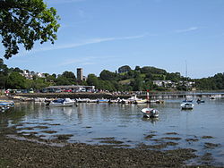
Stoke Gabriel - the creek beyond the mill pond
West Country.png
Red pog.svg
Stoke Gabriel
United Kingdom adm location map.svg
Red pog.svg
Stoke Gabriel
Location within Devon
Europe blank laea location map.svg
Red pog.svg
Stoke Gabriel
Stoke Gabriel (Europe)
Devon UK location map.svg
Red pog.svg
Stoke Gabriel
Stoke Gabriel (Devon)
Population1,107 
OS grid reference SX850572
District
Shire county
Region
Country England
Sovereign state United Kingdom
Post town TOTNES
Postcode district TQ9
Dialling code 01803
Police Devon and Cornwall
Fire Devon and Somerset
Ambulance South Western
UK Parliament
List of places
UK
England
Devon
50°24′12.2″N3°37′16.3″W / 50.403389°N 3.621194°W / 50.403389; -3.621194

Stoke Gabriel is a village and parish in Devon, England, situated on a creek of the River Dart. The village is a popular tourist destination in the South Hams and is famous for its mill pond and crab fishing (known colloquially as crabbing). It is equidistant from Paignton, Dartmouth and Totnes, and has a population of approximately 1,200, reducing slightly to 1,107 at the 2011 census. [1] The village is the major part of the electoral ward of East Dart. The ward population at the abovementioned census was 1,877. [2]

Contents

Fisherman probably first came to Stoke Gabriel to fish salmon and gain access to the River Dart. The village has an approximately 1,000-year-old yew tree [3] in the churchyard of The Church of St Mary and St Gabriel, a church which has stood since Norman times. Legend has it that if you walk backwards seven times round the yew's main stem you will be granted a wish. [4]

Stoke Gabriel by Henry B. Wimbush, c. 1910 H. B. Wimbush, Stoke Gabriel.jpg
Stoke Gabriel by Henry B. Wimbush, c. 1910

The village has two public houses; The Church House Inn [5] and The Castle Inn. Until relatively recently[ when? ] there were three pubs. The other being The Victoria and Albert Inn. The Church House Inn was built to accommodate the masons who constructed the church and also served as the courthouse. The old stocks can be seen outside the inn today.

Stoke Gabriel is the template for the fictional village of Thornford Regis in C. C. Benison's crime novels Twelve Drummers Drumming and Eleven Pipers Piping.

Notable people

Related Research Articles

<span class="mw-page-title-main">Worstead</span> Human settlement in England

Worstead is a village and civil parish in the English county of Norfolk. It lies 3 miles (5 km) south of North Walsham, 5 miles (8 km) north of Wroxham, and 13 miles (21 km) north of Norwich. The village is served by Worstead railway station on the Bittern Line. For the purposes of local government, the parish falls within the district of North Norfolk.

<span class="mw-page-title-main">Saltfleet</span> Coastal village in the East Lindsey district of Lincolnshire, England

Saltfleet is a coastal village in the East Lindsey district of Lincolnshire, England. It is approximately 8 miles (13 km) north of Mablethorpe and 11 miles (18 km) east of Louth.

<span class="mw-page-title-main">Painswick</span> Human settlement in England

Painswick is a town and civil parish in the Stroud District in Gloucestershire, England. Originally the town grew from the wool trade, but it is now best known for its parish church's yew trees and the local Rococo Garden. The village is mainly constructed of locally quarried Cotswold stone. Many of the buildings feature south-facing attic rooms once used as weavers' workshops.

<span class="mw-page-title-main">Woore</span> Human settlement in England

Woore is a village and civil parish in the north east of Shropshire, England. The population of the village as recorded in the 2011 census is 633, and for the civil parish is 1,069. The civil parish extends to about 3,950 acres.

<span class="mw-page-title-main">Mosterton</span> Human settlement in England

Mosterton is a village and civil parish in Dorset, England, situated approximately 3 miles (4.8 km) north of Beaminster. In the 2011 census the parish had a population of 604.

<span class="mw-page-title-main">Chew Stoke</span> Village and civil parish in Somerset, England

Chew Stoke is a small village and civil parish in the affluent Chew Valley, in Somerset, England, about 8 miles (13 km) south of Bristol and 10 miles north of Wells. It is at the northern edge of the Mendip Hills, a region designated by the United Kingdom as an Area of Outstanding Natural Beauty, and is within the Bristol and Bath green belt. The parish includes the hamlet of Breach Hill, which is approximately 2 miles (3.2 km) southwest of Chew Stoke itself.

<span class="mw-page-title-main">Pilning</span> Human settlement in England

Pilning is a village in South Gloucestershire, England, close to Redwick and Severn Beach. Pilning is close to the M4, M49 and A403 roads, and has the South Wales Main Line railway running through it, with a minor station.

<span class="mw-page-title-main">All Stretton</span> Human settlement in England

All Stretton is a village and a now separate civil parish in Shropshire, England. Much of it is covered by a Conservation Area.

<span class="mw-page-title-main">Overton-on-Dee</span> Village in Wales

Overton or Overton-on-Dee is a village and community in Wrexham County Borough, Wales. It is situated close to the Welsh-English border on the edge of an escarpment that winds its way around the course of the River Dee, from which Overton-on-Dee derives its name.

<span class="mw-page-title-main">Frampton on Severn</span> Human settlement in England

Frampton on Severn is a village and civil parish in Gloucestershire, England. The population is 1,432.

<span class="mw-page-title-main">Harrow on the Hill</span> Residential area of north west London, England

Harrow on the Hill or Harrow-on-the-Hill is a locality and historic village in the borough of Harrow in Greater London, England. The name refers to Harrow Hill, 408 feet (124 m), and is located some half a mile south of the modern town of Harrow. The village dates back to early medieval times, built around the 11th-century St Mary's Church, and is the location of Harrow, St Dominic's and John Lyon schools.

<span class="mw-page-title-main">Crowhurst, East Sussex</span> Village in East Sussex, England

Crowhurst is an isolated village situated five miles (8 km) north-west of Hastings in East Sussex. It has a parish council and is located within the Rother District Council.

<span class="mw-page-title-main">Broughton Hackett</span> Human settlement in England

Broughton Hackett is a village and civil parish in the Wychavon district of the county of Worcestershire, England. It is about 5 miles east of the city of Worcester, on the A422 and according to the 2001 census had a population of 173.

<span class="mw-page-title-main">Easebourne</span> Human settlement in England

Easebourne is a village, Anglican parish and civil parish in the Chichester District of West Sussex, England. It is half a mile (0.8 km) north of Midhurst, across the River Rother on the A272 and A286 roads. The parish includes the hamlet of Henley to the north. In the 2001 census there were 708 households with a total population of 1,717 of whom 785 were economically active.

<span class="mw-page-title-main">Frant</span> Village in East Sussex, England

Frant is a village and civil parish in the Wealden District of East Sussex, England, on the Kentish border about three miles (5 km) south of Royal Tunbridge Wells.

<span class="mw-page-title-main">Stoke Holy Cross</span> Human settlement in England

Stoke Holy Cross is a village in South Norfolk which lies approximately 4 miles (6.4 km) south of Norwich.

<span class="mw-page-title-main">Wixford</span> Human settlement in England

Wixford is a hamlet and civil parish in the Stratford-on-Avon District of Warwickshire, England, situated 1.5 miles (2.4 km) south of Alcester. The population at the 2011 census was 155. The area is largely agricultural with no large employers in the area, most residents commuting to larger towns nearby.

<span class="mw-page-title-main">Stoke Canon</span> Village and civil parish in Devon, England

Stoke Canon is a small village and civil parish near the confluence of the rivers Exe and Culm on the main A396 between Exeter and Tiverton in the English county of Devon, and the district of East Devon. At the 2001 census, it had a population of 660. The population was unchanged in 2011 but the village forms the major part of the Exe Valley electoral ward. The population of this ward was 2,041 at the 2011 Census.

<span class="mw-page-title-main">Curdridge</span> Human settlement in England

Curdridge is a village and civil parish within the City of Winchester district of Hampshire, England. The parish also contains the similarly named village of Curbridge. The village has a small school. The parish is located eight miles to the east of Southampton and had a population of 1,292 people in 473 households in the 2001 census, the population increasing to 1,398 in 520 households at the 2011 Census. Curdridge is also known for its annual Curdridge Country Show that takes place in a field off Reading Room Lane

<span class="mw-page-title-main">Funtington</span> Human settlement in England

Funtington is a village and civil parish in the Chichester district of West Sussex, England. It lies on the B2146 Road 4.5 miles (7.2 km) west of Chichester. The parish also contains the villages of East and West Ashling, West Stoke and the Kingley Vale National Nature Reserve lies at its northern tip. There is a farm produce shop and a pub at the centre of the village. Funtington Primary School is in the village of West Ashling.

References

  1. "Parish population 2011" . Retrieved 19 February 2015.
  2. "East Dart ward 2011" . Retrieved 19 February 2015.
  3. "The Yew Tree". Stoke Gabriel Church. Retrieved 31 August 2020.
  4. "The Parish Church of St Mary and St Gabriel" . Retrieved 31 December 2016.
  5. "Church House Inn". Stoke Gabriel Church. Retrieved 7 September 2021.
  6. Beazley, Charles Raymond (1911). "Davis, John"  . Encyclopædia Britannica . Vol. 7 (11th ed.). pp. 868–869.