
South Hams is a local government district on the south coast of Devon, England. Its council is based in the town of Totnes, although the largest town is Ivybridge. The district also contains the towns of Dartmouth, Kingsbridge and Salcombe and numerous villages and surrounding rural areas.

Aveton Gifford is a small rural village in the south of the English county of Devon. It lies at the head of the estuary of the River Avon or Aune, at the point where it is crossed by the A379 road. It receives its name from this river and also from the family of Giffard who held the manor. Walter Giffard came across with William the Conqueror and helped with the Domesday Book.

Ryme Intrinseca is a village and civil parish in northwest Dorset, England, 4 miles (6.4 km) south of Yeovil and 1 mile (1.6 km) west of Yetminster. It is sited on a low ridge of cornbrash limestone on the edge of the Blackmore Vale. The Intrinseca part of the name derives from the existence of the manors of Long Bredy and Langton Herring in the south of the county which also went by the name Ryme; that Ryme was known as Ryme Extrinsica but the name has long fallen out of use. In the 2011 census the parish had a population of 115.

Hordle is a village and civil parish in the county of Hampshire, England. It is situated between the Solent coast and the New Forest, and is bordered by the towns of Lymington and New Milton. Like many New Forest parishes Hordle has no village centre. The civil parish includes the hamlets of Tiptoe and Everton as well as part of Downton. The parish was originally much larger; stretching from the New Forest boundary to Hurst Castle.

Shaldon is a village and civil parish in the Teignbridge district, in south Devon, England, on the south bank of the estuary of the River Teign, opposite Teignmouth. The village is a popular bathing place and is characterised by Georgian architecture.
Allhallows is a village and civil parish on the Hoo Peninsula in Kent, England. Situated in the northernmost part of Kent, and covering an area of 23.99 km2, the parish is bounded on the north side by the River Thames, and in the east by the course of Yantlet creek, now silted up. At the 2011 census the parish had a population of 1,676.
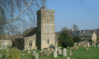
Ascott-under-Wychwood is a village and civil parish in the Evenlode valley about 4.5 miles (7 km) south of Chipping Norton, Oxfordshire, England. The 2011 Census recorded the parish's population as 560.

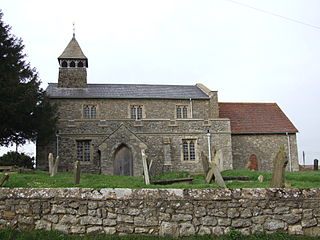
Bigbury is a village and civil parish in the South Hams district of Devon, England. According to the 2001 census the parish had a population of 582, compared to 260 in 1901, and decreasing to 500 in 2011. The southern side of the parish lies on the coast, and it is surrounded clockwise from the west by the parishes of Ringmore, Modbury, Aveton Gifford, and on the opposite bank of the estuary of the River Avon, Thurlestone. Road access to the parish is via the A379 and the B3392. The parish council meets on the second Wednesday of every month at 7.30pm in Bigbury Memorial Hall.
Buckland Brewer is a village and civil parish in the Torridge district of Devon, England, 4.7 miles south of Bideford. Historically the parish formed part of Shebbear Hundred. According to the 2001 census it had a population of 777, increasing to 794 at the 2011 census The village is part of Waldon electoral ward. The population for this at the same census was 1,679.

Heanton Punchardon ( ) is a village, civil parish and former manor, anciently part of Braunton Hundred. It is situated directly east-southeast of the village of Braunton, in North Devon. The parish lies on the north bank of the estuary of the River Taw and it is surrounded, clockwise from the north, by the parishes of Braunton, Marwood, Ashford and across the estuary, Fremington. The population was 418 in 1801 and 404 in 1901. Its largest localities are Wrafton and Chivenor. The surrounding area is also an electoral ward with a total population at the 2011 census of 2,673.

Bigbury-on-Sea is a village in the South Hams district on the south coast of Devon, England. It is part of the civil parish of Bigbury which is centred on a small village of that name about a mile inland. Bigbury-on-Sea village is on the coast above the largest sandy beach in South Devon facing south to Bigbury Bay. The tidal island of Burgh Island lies about 270 yards offshore.

Iddesleigh is a village and civil parish in the county of Devon, England. The settlement has ancient origins and is listed in the Domesday Book. The village lies on the B3217 road, roughly central in its parish of around 2,900 acres (1,200 ha), about 8 miles (13 km) north of the town of Okehampton.

Otterton is a village and civil parish in East Devon, England. The parish lies on the English Channel and is surrounded clockwise from the south by the parishes of East Budleigh, Bicton, Colaton Raleigh, Newton Poppleford and Harpford and Sidmouth. In 2001 its population was 700, compared to 622 a hundred years earlier. At the 2011 census the population had reduced to 656. Otterton is part of Raleigh electoral ward whose total population at the above census was 2,120.

Hallow is a village and civil parish beside the River Severn, about 2 miles (3.2 km) north-west of Worcester in Worcestershire. The village is on the A443 road that links Worcester with Holt Heath.

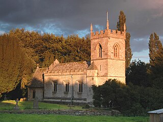
Stretton-on-Fosse is a village in the Stratford District in Warwickshire, England. It is situated between the towns of Moreton-in-Marsh and Shipston-on-Stour. The village is situated along the ancient Fosse Way road which runs from Exeter in Devon to Lincoln in Lincolnshire. The road bypasses the village to the east and is now the modern-day A429 road. The village is close to the Gloucestershire and Warwickshire border. While the lower ground of the village is heavy clay the upper parts are composed of sand and shingle. During commercial extraction of sand important graves of the Roman-British and Anglo-Saxon periods were uncovered and interesting skeletons and personal belongings were unearthed. These burials were the result of internecine warfare between local tribal factions.

Alkerton is a village and former civil parish, now in the parish of Shenington with Alkerton, in the Cherwell district, in the county of Oxfordshire, England. It is on the county boundary with Warwickshire, about 5 miles (8 km) west of Banbury. In 1961 the parish had a population of 82. On 1 April 1970 the parish was abolished and merged with Shenington to form "Shenington with Alkerton".
The hundred of Ermington was the name of one of thirty two ancient administrative units of Devon, England. It was active until the end of the 19th century when more specialized governmental units assumed its many roles.
Westcott Barton, also spelt Wescot Barton or Wescote Barton, is a village and civil parish on the River Dorn in West Oxfordshire about 7 miles (11 km) east of Chipping Norton and about 9+1⁄2 miles (15 km) south of Banbury, in the county of Oxfordshire, England. The parish is bounded to the north by Cockley Brook, a tributary of the River Dorn. A minor road to Kiddington forms part of the eastern boundary, another minor road forms part of the western boundary and the remainder of the parish boundaries are field boundaries. Westcott Barton's main area of housing is on the eastern boundary of the parish and contiguous with the village of Middle Barton in the neighbouring parish of Steeple Barton. The 2011 Census recorded the parish's population as 244.

Halwell and Moreleigh is a civil parish in the South Hams district, in the county of Devon, England. It comprises the villages of Halwell and Moreleigh. In 2011 it had a population of 446.
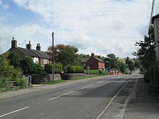
Rushton is a civil parish in Staffordshire, England. The village within the civil parish, usually known as Rushton Spencer, is about 4 miles (6.4 km) north of Leek and 7 miles (11 km) south of Macclesfield, on the A523 road which runs between these towns.


