West Parley

Last updated • 5 min readFrom Wikipedia, The Free Encyclopedia

West Parley
Parley Cross - geograph.org.uk - 1171530.jpg
Parley Cross road junction
Dorset UK location map.svg
Red pog.svg
West Parley
Location within Dorset
Population3,585 (2011)
OS grid reference SZ081984
Civil parish
  • West Parley
Unitary authority
Ceremonial county
Region
Country England
Sovereign state United Kingdom
Post town FERNDOWN
Postcode district BH22
Dialling code 01202
Police Dorset
Fire Dorset and Wiltshire
Ambulance South Western
UK Parliament
List of places
UK
England
Dorset
50°47′10″N1°53′10″W / 50.786°N 1.886°W / 50.786; -1.886

West Parley is a village and civil parish in south-east Dorset, England, situated on the River Stour between Bournemouth and Ferndown and off of the B3073 road. The parish of West Parley covers an area of 4.52 square kilometres (1,120 acres). [1] It is also about 4 miles (6.4 km) to the closest major town of Bournemouth. West Parley has a primary school, a post office, a garden centre and a church. In the 2011 census the parish had a population of 3,585. [2]

Contents

Shops at Parley Cross Shops at Parley Cross - geograph.org.uk - 511190.jpg
Shops at Parley Cross
Map of West Parley, 1945 shown by Ordnance Survey Map excerpt for West Parley.png
Map of West Parley, 1945 shown by Ordnance Survey

History

West Parley is older than both Bournemouth and Ferndown, it features in the Domesday Book when it had 60 inhabitants. At that time it had a Saxon Church, replaced by the present All Saints Church in the 12th century. There is evidence of West Parley being much older as Dudsbury Rings, to the South West of West Parley is the remains of a hill fort dated to the Iron Age, it can be seen as a defensive site that overlooks the River Stour. The walls of the fort can still be seen today. [3]

In 1870–1872 West Parley was described by John Marius Wilson in the Imperial Gazetteer of England and Wales as

"The living is a rectory in the diocese of Salisbury. The church is ancient; and there is an Independent chapel". [4]

In the 1800s the main source of materials were gravel and clay and these were important in helping build within West Parley, the materials enabled the local community to create tracks that were passable and the clay meant that the workers could use the bricks to build houses within West Parley as well as supplying the city of Bournemouth with bricks for the construction. [5]

On 16 January 2023, a fire broke out in the roof of the West Parley Memorial Hall. [6]

Demographics

Population

Over the last 200 years the population of West Parley has changed dramatically, In 1801 the population of West Parley was 180, since then the population has mainly increased, the total population decreased three times since then, once where the population went from 180 in 1801 to 175 in 1811. The second time went from 336 in 1881 to 334 in 1891, the largest increases were during the Baby Boom from 1921 to 1951, this was when everyone was procreating tenfold due to welfare benefits and due to lower income jobs. From 1921 to 1931 the population rose from 1,130 to 1,671 and then from 1931 to 1951 the population rose to a huge 2,947, this may also be due to the fact that children were also moved to small areas in the countryside and this can also account for the drop to 2,002 people in 1961. [7]

Total Population of West Parley Civil Parish, Dorset as reported by the Census of Population from 1801 to 2011 Population time series graph.jpg
Total Population of West Parley Civil Parish, Dorset as reported by the Census of Population from 1801 to 2011

Housing

There is a total of 1,562 houses, the largest house is with 8 residents and there is only one of these, the majority of the housing is for 2 people and there is 733 of these households and the second amount is one person per household with 377 people. [8]

Age Structure

Information published by the 2011 census shows that 22.1% of the population was aged between 45–59, this means that it is the largest age group in West Parley, the second largest group in the area was 65–79 which equated to 17.1% of the total population, 79.7% of the population are aged 25 and over and the largest age group remaining out of the 20.3% is 10–14 which equates to 4.4% of the total population and so the population of West Parley is an ageing population as there are fewer younger residents. [9]

Employment

Occupation of women in 1881 shown by the census West Parley female occupation in 1881.png
Occupation of women in 1881 shown by the census

In 1881 the main employment for males was agriculture with 45 people, during this era this was the common practice and therefore this is not peculiar, however 37 females had an unknown occupation, the main occupation for females at this date was for domestic services or offices and this only had a total of 8 women which shows the inequality at the time. [10]

According to the 2001 census the number of full-time employees aged 16–74 years of age was 733 people, the number of part-time workers was 316 and the self-employed workers equated to 290 people [11] The main industry of employment was wholesale & retail trade; repair of motor vehicles with 283 people with the second largest being real estate with 170 people. [12] In comparison, the 2011 census shows that there was 758 full-time employees, 408 part-time workers and 335 self-employed people. [13] Wholesale and retail trade was still the main industry of employment in 2011 with 304 people and the second largest was in fact Human health and social work activities with 174 people. [14]

Male occupation in West Parley from the 1881 census West Parley male occupation in 1881.png
Male occupation in West Parley from the 1881 census

Ethnicity

In the 2001 census of the total population of 3,532 the largest ethnicity of West Parley was White British with 3,438 people, this only leaves 94 residents that are not White British, 76 of these residents are also white which means that there are only 18 people of other ethnicities and this means that there is not many different ethnicities such as 5 Chinese and 13 mixed ethnicities in West Parley during 2001. [15] In contrast in the 2011 census there was 3,460 White British out of a total population of 3,585, there are a further 78 white residents leaving 22 mixed race and 22 Asian residents as well 3 other ethnic group, this shows that there has been an increase in ethnic diversity since 2001. [16]

Politics

After 2019 structural changes to local government in England, West Parley is part of the West Parley ward which elects 2 members to Dorset Council. [17]

Related Research Articles

<span class="mw-page-title-main">East Dorset</span> Former non-metropolitan district in England

East Dorset was a local government district in Dorset, England. Its council met in Wimborne Minster between 2016 and 2019.

<span class="mw-page-title-main">City of Bradford</span> City and metropolitan borough in West Yorkshire, England

Bradford, also called the City of Bradford, is a metropolitan borough in West Yorkshire, England. It is named after its largest settlement, Bradford, but covers a larger area which includes the towns and villages of Keighley, Shipley, Bingley, Ilkley, Haworth, Silsden, Queensbury, Thornton and Denholme. Bradford has a population of 528,155, making it the fourth-most populous metropolitan district and the sixth-most populous local authority district in England. It forms part of the West Yorkshire Urban Area conurbation which in 2011 had a population of 1,777,934, and the city is part of the Leeds-Bradford Larger Urban Zone (LUZ), which, with a population of 2,393,300, is the fourth largest in the United Kingdom after London, Birmingham and Manchester.

<span class="mw-page-title-main">Ferndown</span> Human settlement in England

Ferndown is a town and civil parish in Dorset in southern England, immediately to the north of Bournemouth and Poole. The parish, which until 1972 was called Hampreston, includes the communities of Hampreston, Longham, Stapehill and Trickett's Cross. At the 2011 Census, the population of the parish was 26,559, making Ferndown the largest inland town in Dorset in terms of population, being larger than Dorchester.

<span class="mw-page-title-main">Moor Crichel</span> Human settlement in England

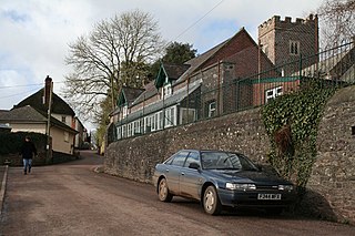
Moor Crichel is a village and former civil parish, now in the parish of Crichel, in East Dorset, England situated on Cranborne Chase five miles east of Blandford Forum. The civil parish includes the hamlet of Manswood notable for a terrace of twelve thatched cottages. Dorset County Council's 2013 estimate of the parish population is 140. In the 2001 census the parish had a population of 180. In the 2011 census the population of Moor Crichel parish combined with the neighbouring parish of Long Crichel was 246. The civil parish was abolished on 1 April 2015 and merged with Long Crichel to form Crichel.

<span class="mw-page-title-main">Christchurch (UK Parliament constituency)</span> UK Parliament constituency since 1983

Christchurch is a constituency in Dorset represented in the House of Commons of the UK Parliament since 1997 by Sir Christopher Chope of the Conservative Party.

<span class="mw-page-title-main">Acton Turville</span> Human settlement in England

Acton Turville is a parish in the Cotswold Edge ward within South Gloucestershire, England. It lies 17 miles (27 km) east-northeast of Bristol and 93 miles (150 km) due west of London, with the M4 south of the parish. Acton Turville consists of a cluster of households across 1,009 acres, with a total population of 370 people. Acton Turville is also listed as "Achetone" in the Domesday Book.

<span class="mw-page-title-main">Easton, Cambridgeshire</span> Human settlement in England

Easton is a village and civil parish in Cambridgeshire, England. Easton lies approximately 6 miles (10 km) west of Huntingdon, between the villages of Ellington and Spaldwick. Easton is situated within Huntingdonshire which is a non-metropolitan district of Cambridgeshire as well as being a historic county of England. Easton is a hamlet which the Anglo Saxons settled in.

<span class="mw-page-title-main">South East Dorset conurbation</span> Population centre in Southern England

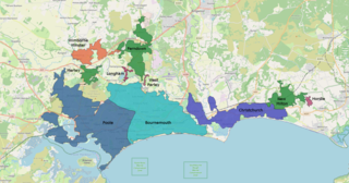
The South East Dorset conurbation is a multi-centred conurbation on the south coast of Dorset in England.

<span class="mw-page-title-main">Badingham</span> Human settlement in England

Badingham is a civil parish in the East Suffolk district of eastern England, in the county of Suffolk. It is situated 21.8 miles north east of Ipswich, 35 miles (56 km) away from Norwich and 13 miles (21 km) away from the coast. With the road "A1120" slicing through the middle of the parish. Badingham's name is Anglo-Saxon and means "the farmstead of Bada’s people". Badingham contains a significant number of farms, sparse amount of housing, numerous B&Bs as well as St. John's Church.

<span class="mw-page-title-main">Darenth</span> Human settlement in England

Darenth is a village and civil parish in the Borough of Dartford, Kent, England. It is located 3.4 miles south east of Dartford and 4.6 miles north east of Swanley.

<span class="mw-page-title-main">Tingrith</span> Human settlement in England

Tingrith is a small village and civil parish in Bedfordshire, England. It is located adjacent to the M1 motorway near the large village of Toddington. The nearest major town is Luton, located about 10 miles (16 km) to the southeast. The parish church of St Nicholas dates back to the 13th century and has Tingrith's only cemetery. The church can seat up to 200 people.

<span class="mw-page-title-main">Nether Langwith</span> Village and civil parish in England

Nether Langwith is a village and civil parish, in the Bassetlaw district of Nottinghamshire, England. It is located 9 miles (14 km) east of Chesterfield and 8 miles (13 km) south west of Worksop. Nether Langwith lies east of the adjoining village, Langwith, which is in the district of Bolsover in Derbyshire, England. It is 527 hectares in size and lies on the banks of the River Poulter. The population at the 2011 census was 526, decreasing to 478 in 2021.

<span class="mw-page-title-main">Heveningham</span> Village in Suffolk, England

Heveningham is a village and civil parish in the East Suffolk district of Suffolk in eastern England. Located four miles south-west of Halesworth, in 2005 it had a population of 120.

<span class="mw-page-title-main">Sourton</span> Village in Devon, England

Sourton is a small village and civil parish in West Devon, England. It lies about 4 miles (6.4 km) south-west of Okehampton. It is at the north-western extremity of Dartmoor, a National Park of England and Wales, and lies along the A386 road. The historic map of Sourton shows that it is located near a river and the Sourton forest this can be seen in the image below.

<span class="mw-page-title-main">Great Moulton</span> Human settlement in England

Great Moulton is a civil parish in the English county of Norfolk. Until the 16th century it also included the Little Moulton parish.

<span class="mw-page-title-main">Great Tey</span> Human settlement in England

Great Tey is a village and civil parish in the City of Colchester district of Essex, England. It is near the villages of Marks Tey and Little Tey, located approximately six miles west of Colchester.

<span class="mw-page-title-main">Kirton, Suffolk</span> Human settlement in England

Kirton is a village and a civil parish in the shire county of Suffolk, England, situated off the A14 road, about 4.5 km (2.8 mi) from Felixstowe and around 10 km (6.2 mi) from Ipswich. The closest train station to Kirton is Trimley. According to the 2011 census, Kirton had a population of 1,146. It is located between the River Deben and the River Orwell. The village of Kirton covers a total area of 8.3 km2 (3.2 sq mi). As the county of Suffolk lacks quarries, many of the buildings are made from flint, clay and timber.

<span class="mw-page-title-main">Huntingfield, Suffolk</span> Human settlement in England

Huntingfield is a village near the B1117 road, in the East Suffolk district, in the county of Suffolk, England. The village is close to the source of the River Blyth and the parish is 12 miles from the seaside town of Southwold. Nearby settlements include the town of Halesworth and the villages of Walpole, Heveningham, Cookley and Laxfield.

<span class="mw-page-title-main">Layer Breton</span> Human settlement in England

Layer Breton is a village and a civil parish in the City of Colchester district of Essex, England. According to the 2011 census there were 144 males and 143 females. Layer Breton is part of the Layer parishes with Layer de la Haye being the neighbouring village to the west and Layer Marney neighbouring Layer Breton to the East. Layer Breton also touches parishes Birch and Great and little Wigborough. The village has a church dedicated to St Mary the Virgin, rebuilt in brick in 1923 on a new site nearly a mile to the north of the old one. The village was among those which suffered damage from the 1884 Colchester earthquake.

<span class="mw-page-title-main">Poughill, Devon</span> Village in Devon, England

Poughill is a village and civil parish in Devon, England. It lies 5 miles (8 km) north of Crediton. In 2011, the parish had a population of 216.

References

  1. "Office For National Statistics". Neighbourhood Statistics. Office for National Statistics. March 2011. Retrieved 24 March 2016.
  2. "West Parley (Parish): Key Figures for 2011 Census: Key Statistics". Neighborhood Statistics. Office for National Statistics. Retrieved 28 January 2016.
  3. "West Parley Parish Council". West Parley Parish Council. Paul Heaslip. 2011. Retrieved 24 March 2016.
  4. Wilson, John Marius (1870–72). Imperial Gazetteer of England and Wales. Edinburgh: A.Fullerton & Co.
  5. "West Parley Parish Council". 2011. Retrieved 24 March 2016.
  6. "Community hall roof on fire as emergency crews rush to scene". Bournemouth Echo. 16 January 2023. Retrieved 17 January 2023.
  7. "History of population change in Parish of West Parley". A Vision of Britain Through Time. Great Britain Historical GIS/ University of Portsmouth. Retrieved 24 March 2016.
  8. "West Parley (Parish) Household Size, 2011". Neighbourhood Statisticss. Office for National Statistics. March 2011. Retrieved 25 April 2016.
  9. "West Parley (Parish) Age Structure, 2011". Neighbourhood Statistics. Office for National Statistics. March 2011. Retrieved 25 April 2016.
  10. "History of population change in Parish of West Parley". A Vision of Britain Through Time. Great Britain Historical GIS/ University of Portsmouth. Retrieved 24 March 2016.
  11. "West Parley (Parish)-Economic Activity – All People, 2001". Office for National Statistics. Neighbourhood Statistics. April 2001. Retrieved 25 April 2016.
  12. "West Parley (Parish)- Industry of Employment – All People, 2001". Neighbourhood Statistics. Office for National Statistics. April 2001. Retrieved 25 April 2016.
  13. "West Parley (Parish) Economic Activity, 2011". Neighbourhood Statistics. Office for National Statistics. March 2011. Retrieved 25 April 2016.
  14. "West Parley (Parish) Industry 2011". Neighbourhood Statistics. Office for National Statistics. March 2011. Retrieved 25 April 2016.
  15. "West Parley (Parish) Ethnic Group 2001". Neighbourhood Statistics. Office for National Statistics. April 2001. Retrieved 25 April 2016.
  16. "West Parley (Parish) Ethnic Group, 2011". Neighbourhood Statistics. Office for National Statistics. March 2011. Retrieved 25 April 2016.
  17. "Area profile for West Parley - Dorset Council". gi.dorsetcouncil.gov.uk. Retrieved 24 February 2024.

Commons-logo.svg Media related to West Parley at Wikimedia Commons