| Dollis Hill | |
|---|---|
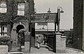
 Island platform at the station | |
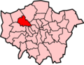
 Dollis Hill Location of Dollis Hill in Greater London | |
| Location | Dollis Hill |
| Local authority | London Borough of Brent |
| Managed by | London Underground |
| Number of platforms | 2 |
| Fare zone | 3 |
| London Underground annual entry and exit | |
| 2020 | |
| 2021 | |
| 2022 | |
| 2023 | |
| 2024 | |
| Railway companies | |
| Original company | Metropolitan Railway |
| Key dates | |
| 1 October 1909 | Opened as Dollis Hill |
| 1931 | Renamed Dollis Hill and Gladstone Park |
| 1933 | Renamed Dollis Hill |
| 20 November 1939 | Bakerloo line service introduced |
| 7 December 1940 | Metropolitan line service ceased |
| 1 May 1979 | Bakerloo line service replaced by Jubilee line |
| Other information | |
| External links | |
| Coordinates | 51°33′07″N0°14′19″W / 51.55194°N 0.23861°W |
Dollis Hill is a London Underground station at Dollis Hill, near to Willesden and Gladstone Park in the London Borough of Brent. It is on the Jubilee line between Neasden and Willesden Green stations, and is in London fare zone 3. [6] Metropolitan line trains pass through the station without stopping.