
Alperton is an area of north west London, England, within the London Borough of Brent. It forms the southern part of the town of Wembley and is 7.5 miles (12 km) west north-west of Charing Cross, on the border with the London Borough of Ealing. It includes a handful of high-rise and many mid-rise buildings as well as streets of low-rise houses with gardens. It adjoins the Grand Union Canal's Paddington Arm, which is fed by the Brent Reservoir.

Kingsbury is a district of northwest London in the London Borough of Brent. Its ancient scope stretches to include various distinct areas that were once small villages until the inter-war period. Kingsbury was in 2001 a ward and in 2011 was identifiable with the Fryent and Barnhill wards approximately. Today it forms a quiet suburb between Fryent Country Park to the west and the Brent Reservoir to the east, along with a Jubilee line tube station and accompanying shopping district on the western side. The postal district is NW9 which it shares with Colindale and West Hendon.

Neasden is a suburban area in northwest London, England. It is located around the centre of the London Borough of Brent and is within the NW2 (Cricklewood) and NW10 (Willesden) postal districts. Neasden is near Wembley Stadium, the Welsh Harp, and Gladstone Park; the reservoir and River Brent marks its boundaries with Kingsbury and Wembley, while Gladstone Park and the Dudding Hill line separates it from Dollis Hill and Church End respectively. The A406 North Circular Road runs through the middle of Neasden; to the west is the Neasden Underground Depot, Brent Park retail area and the St Raphael's Estate; on the east is Neasden tube station, the large Neasden Temple, and former Neasden Power Station. The area is known as the place where Bob Marley lived after moving from Jamaica, living at a house in The Circle; the house was honoured with a blue plaque in 2012.
Northolt is a town in West London, England, spread across both sides of the A40 trunk road. It is 11 mi (17.7 km) west-northwest of Charing Cross and is one of the seven major towns that make up the London Borough of Ealing. It had a population of 30,304 at the 2011 UK census.

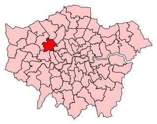
Brent is a borough in north-west London, England. It is known for landmarks such as Wembley Stadium, the Swaminarayan Temple and the Kiln Theatre. It also contains the Welsh Harp reservoir and the Park Royal commercial estate. The local authority is Brent London Borough Council.

Wembley is a large suburb in the London Borough of Brent, north-west London, 8 miles (13 km) northwest of Charing Cross. It includes the neighbourhoods of Alperton, North Wembley, Preston, Sudbury, Tokyngton and Wembley Park. The population was 102,856 in 2011.

Harrow is a large town in Greater London, England, and serves as the principal settlement of the London Borough of Harrow. Lying about 9.5 miles (15.3 km) north-west of Charing Cross and 5.4 miles (8.7 km) south of Watford, the entire town including its localities had a population of 149,246 at the 2011 census, whereas the wider borough had a population of 250,149.

Brent South was a constituency for the House of Commons of the UK Parliament; the areas of the constituency chiefly fell into the new Brent Central for the 2010 general election which was the date of its abolition. It elected one member (MP) by the first past the post system of election.

Queen's Park is an area in North West London and West London, located partly in the City of Westminster and mostly in the London Borough of Brent. Some of the area within Westminster forms a civil parish, the first to be created in London since the right of communities to establish civil parishes was enacted in 2007. The area is located 4 miles (6.4 km) north-west of Charing Cross, and centred around a 30 acres (12 ha) park, which opened in 1887 and was named in honour of Queen Victoria. The area gives its name to Queens Park Rangers football club.
Brent Central was a constituency in Greater London, represented in the House of Commons of the UK Parliament from 2010 until its abolition for the 2024 general election by Dawn Butler of the Labour Party.

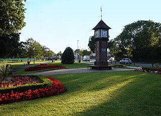
Sudbury is a suburb in the London Borough of Brent, located in northwest London, United Kingdom. The suburb forms the western part of Wembley and is centred around 0.6 miles (1 km) west of Wembley Central railway station.
Roxeth was a hamlet in the ancient Harrow on the Hill parish, which now forms part of the London Borough of Harrow in Greater London, England.

Harrow Road is an ancient route in North West London which runs from Paddington in a northwesterly direction towards Harrow. It is also the name given to the immediate surrounding area of Queens Park and Kensal Green, straddling the NW10, W10, W2 and W9 postcodes. With minor deviations in the 19th and 20th centuries, the route remains otherwise unaltered.
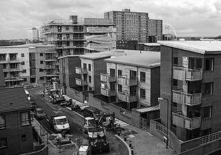
Stonebridge is a locality in the London Borough of Brent. Stonebridge is situated in southern Brent, on Harrow Road between Harlesden and Wembley. The A404 runs through the district known locally as Brentfield and Hillside, while to the south are railway tracks and to the west is the North Circular Road along with Stonebridge Park station. The area is known for the previously troubled 1960s Stonebridge housing estate, which was completely redeveloped in the 2010s.

Brondesbury Park is a suburb and electoral ward of the London Borough of Brent. It is the part of Brondesbury which is not interwoven with Kilburn due to the naming of a major tube station (Kilburn) and is centred on Brondesbury Park railway station and the street, an avenue, which shares its name. The area has a number of open spaces, primarily Queen's Park and Tiverton Green.
Fryent Country Park, together with Barn Hill Open Space, is a large park situated in the north of the London Borough of Brent. It covers 103 hectares of rolling fields and small woods.
St Raphael's Estate is a housing estate in Neasden and part of the London Borough of Brent in Northwest London, England. A community centre is located within the estate on Rainborough Close. It forms part of the NW10 postcode.

Chalkhill Estate is located in the Wembley Park area of North West London. It was originally one of three large council estates built in the London Borough of Brent by the early 1970s, along with Stonebridge and South Kilburn. The design was based on that of Park Hill in Sheffield. The high-rise estate was demolished by 2000 and gradually replaced by new low-rise builds.
The 1968 Brent Council election took place on 9 May 1968 to elect members of Brent London Borough Council in London, England. The whole council was up for election and the Conservative Party gained overall control of the council.


