
The Jubilee line is a London Underground line that runs between Stanmore in suburban north-west London and Stratford in east London, via the Docklands, South Bank and West End. Opened in 1979, it is the newest line on the Underground network, although some sections of track date back to 1932 and some stations to 1879.

Liberty is a town in Waldo County, Maine, United States. The population was 934 at the 2020 census.

Brent East is a parliamentary constituency in north west London; it was replaced by Brent Central for the 2010 general election. It returned one Member of Parliament (MP) to the House of Commons of the Parliament of the United Kingdom, elected by the first past the post system.

Dollis Brook is a waterway which runs through Barnet in north London. It is a tributary of the River Brent, which is itself a tributary of the River Thames.

Brent North was a constituency represented in the House of Commons of the UK Parliament from 1997 until its abolition for the 2024 general election by Barry Gardiner of the Labour Party.

Brent South was a constituency for the House of Commons of the UK Parliament; the areas of the constituency chiefly fell into the new Brent Central for the 2010 general election which was the date of its abolition. It elected one member (MP) by the first past the post system of election.

Wembley was an urban district and later a municipal borough in Middlesex, England from 1894 to 1965.
The London Borough of Barnet, located on the northern periphery of London and having much of the area within its boundaries in the Metropolitan Green Belt, has many parks and open spaces. In addition there are large areas taken over by cemeteries and golf courses, and part of Hampstead Heath.

Central Middlesex Hospital is in the centre of the Park Royal business estate, on the border of two London boroughs, Brent and Ealing. It is managed by the London North West University Healthcare NHS Trust.

Brent Park is a retail area of Neasden in the London Borough of Brent, located by the A406 North Circular Road and to the south of Neasden Depot. It includes an IKEA store, along with a Tesco Extra superstore, and bounded by a McDonald's restaurant on the south-west.
Fryent Country Park, together with Barn Hill Open Space, is a large park situated in the north of the London Borough of Brent. It covers 103 hectares of rolling fields and small woods.

Northwick Park is a formerly larger public park in the London Borough of Brent between eastern Harrow and Kenton, north-west London. Most of the park consists of playing fields, kite flying areas, and trees. It has often lent its name to an electoral ward of Brent, including namesake tube station, and typically most of North Wembley. It is between the mentioned station on the and South Kenton station on the Bakerloo line.

Barpa Langass, is a Neolithic chambered cairn on the Isle of North Uist in the Outer Hebrides of Scotland. It measures about 72 feet in diameter by 18 feet in height, and is around 5,000 years old. The roof is constructed of two massive slabs with a third slab superimposed.
St Raphael's Estate is a housing estate in Neasden and part of the London Borough of Brent in Northwest London, England. A community centre is located within the estate on Rainborough Close. It forms part of the NW10 postcode.
The Uxendon Shooting School Club was a club devoted to shooting sports located in Preston, in what is now the borough of Brent in London, England. It was between the Wealdstone Brook and Barn Hill, roughly where Alverstone Road is now. It hosted the trap shooting events for the 1908 Summer Olympics.

Clarefield Park is a small park and Site of Local Importance for Nature Conservation in Brent Cross in the London Borough of Barnet.
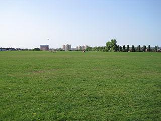
Clitterhouse Recreation Ground or Clitterhouse Playing Fields is a park and Site of Local Importance for Nature Conservation in Brent Cross in the London Borough of Barnet. It is a large area of mown grass with a children's playground, bordered by thick hedges. Clitterhouse Stream, a tributary of the River Brent, runs along its eastern border.

West Hendon Playing Fields is a 62 acre public park in West Hendon in the London Borough of Barnet. It is one of Barnet's Premier Parks.

Brent Park is a small public park of 2.24 hectares in Hendon in the London Borough of Barnet. It is part of the 'Lower Dollis Brook' Site of Borough Importance for Nature Conservation, Grade II.

Masons Field is a 2.9 hectare Local Nature Reserve (LNR) in Kingsbury in the London Borough of Brent. It was declared an LNR in 2013, it is owned by London Underground Ltd and managed by Brent Council on a 125-year leasehold.

