
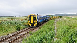
Achnashellach railway station is a railway station serving Achnashellach on the Kyle of Lochalsh Line, in Wester Ross, Scotland. The station lies between Strathcarron and Achnasheen, 40 miles 34 chains (65.1 km) from Dingwall. ScotRail, who manage the station, operate all services.

The Kyle of Lochalsh line is a primarily single-track railway line in the Scottish Highlands, from Dingwall to Kyle of Lochalsh. Many of the passengers are tourists, but there are also locals visiting Inverness for shopping, and commuters. All services are provided by ScotRail and run beyond Dingwall to Inverness. In the past there were some through services to and from Glasgow, Edinburgh or Aberdeen. None of the 63-mile line is electrified, and all trains on the line are diesel-powered, as are all other trains in the Scottish Highlands.
The Far North Line is a rural railway line entirely within the Highland area of Scotland, extending from Inverness to Thurso and Wick. As the name suggests, it is the northernmost railway in the United Kingdom. The line is entirely single-track, with only passing loops at some intermediate stations allowing trains to pass each other. Like other railway lines in the Highlands and northern Lowlands, it is not electrified and all trains are diesel-powered.

Dingwall railway station serves Dingwall, Scotland. It is located just south of the junction of the Far North Line and the Kyle of Lochalsh Line, and is managed and served by ScotRail. The station is 18 miles 58 chains (30.1 km) from Inverness, and is the zero point for the Kyle of Lochalsh Line. It is sited after Conon Bridge heading northbound, with the next station being either Garve or Alness.

Achanalt railway station is a geographically remote railway station on the Kyle of Lochalsh Line, serving the village of Achanalt in the north of Scotland. The station is 21 miles 34 chains (34.5 km) from Dingwall, between Lochluichart and Achnasheen. ScotRail, who manage the station, operate all services.
Muir of Ord railway station is a railway station on the Kyle of Lochalsh Line and the Far North Line, serving the village of Muir of Ord in the Highland council area of Scotland. The station is 13 miles 4 chains from Inverness, between Beauly and Conon Bridge, and is the location of the sole remaining passing loop on the single line between Dingwall and Inverness.

Garve railway station is a railway station on the Kyle of Lochalsh Line, serving the village of Garve in the north of Scotland. Garve is located at the eastern edge of Loch Garve, measured 11 miles 65 chains (19.0 km) from Dingwall, and is the first stop on the line before Lochluichart. ScotRail, who manage the station, operate all services.
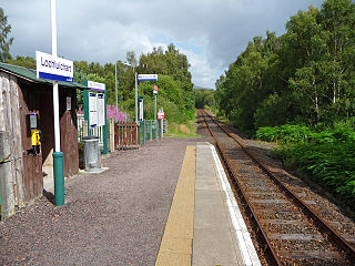
Lochluichart railway station is a railway station on the Kyle of Lochalsh Line, serving the village of Lochluichart in the north of Scotland. The station is located at the north edge of Loch Luichart, 17 miles 20 chains (27.8 km) from Dingwall, between Garve and Achanalt. ScotRail, which manages the station, operates all services.

Achnasheen railway station is a remote railway station on the Kyle of Lochalsh Line, serving the village of Achnasheen in the north of Scotland. The station is 27 miles 72 chains (44.9 km) from Dingwall, between Achanalt and Achnashellach. ScotRail, who manage the station, operate all services.

Attadale railway station is a remote railway station on the Kyle of Lochalsh Line, serving the village of Attadale on Loch Carron in the Highlands, northern Scotland. The station is 48 miles 22 chains (77.7 km) from Dingwall, between Strathcarron and Stromeferry. ScotRail, who manage the station, operate all services.

Duirinish railway station is a remote railway station on the Kyle of Lochalsh Line near the settlement of Duirinish in the Highlands, northern Scotland. The station is approximately 2 miles (3 km) inland of Scotland's west coast, near Loch Lundie. The station is 59 miles 58 chains (96.1 km) from Dingwall, between Kyle of Lochalsh and Plockton. ScotRail, who manage the station, operate all services here.

Kyle of Lochalsh railway station is the terminus of the Kyle of Lochalsh Line in the village of Kyle of Lochalsh in the Highlands, northern Scotland. The station is 63 miles 64 chains (102.7 km) from Dingwall. ScotRail, who manage the station, operate all of the services here.

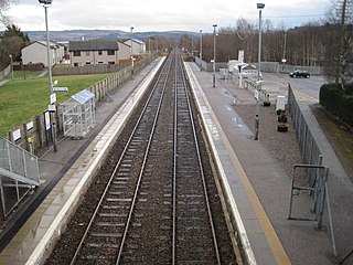
Alness railway station is a railway station on the Far North Line, serving the town of Alness, on the Cromarty Firth, in the Highland council area of Scotland. The station is 28 miles 70 chains (46.5 km) from Inverness, between Dingwall and Invergordon. ScotRail, who manage the station, operate all services.

Fearn railway station is a railway station serving the village of Hill of Fearn in the Highland council area of Scotland, located around 1.3 miles (2.1 km) from the village. It is situated on the Far North Line, 40 miles 60 chains (65.6 km) form Inverness, between Tain and Invergordon, and is also the nearest station to Balintore, Hilton and Shandwick, Portmahomack and the Nigg Bay area of Easter Ross. ScotRail, who manage the station, operate all services.

Wick railway station is a railway station located in Wick, in the Highland council area in the far north of Scotland. It serves the town of Wick and other surrounding areas in the historic county of Caithness, including Staxigoe, Papigoe and Haster. The station is the terminus of the Far North Line, 161 miles 36 chains from Inverness. It is managed by ScotRail, who operate all trains serving the station.
The Dingwall and Skye Railway was authorised on 5 July 1865 with the aim of providing a route to Skye and the Hebrides. However, due to local objections, another Act of Parliament was required before work could commence. This was passed on 29 May 1868.
Achterneed railway station was a railway station serving Strathpeffer and located on the Kyle of Lochalsh Line, in Wester Ross, Highland, Scotland.

Allangrange railway station was a station on the single track branch of the Highland Railway, in north east Scotland. The line connected villages in The Black Isle peninsula to the railway network via a junction at Muir of Ord.

Conon Bridge is a railway station on the Far North and Kyle of Lochalsh Lines, which serves the villages of Conon Bridge and Maryburgh in the Scottish Highlands. Initially known as Conon, it originally closed in 1960 and reopened on 8 February 2013. The station is 16 miles 21 chains (26.2 km) from Inverness, between Muir of Ord and Dingwall.

Avoch railway station was a station on the single track branch of the Highland Railway, in north east Scotland. The line connected villages in The Black Isle peninsula to the railway network via a junction at Muir of Ord.

