Alcaig

Last updated

Alcaig
View over Dingwall to Ben Wyvis, from Alcaig.jpg
View over Dingwall to Ben Wyvis, from Alcaig
Ross and Cromarty UK location map.svg
Red pog.svg
Alcaig
Location within the Ross and Cromarty area
OS grid reference NH5657
Council area
Country Scotland
Sovereign state United Kingdom
Police Scotland
Fire Scottish
Ambulance Scottish
UK Parliament
Scottish Parliament
List of places
UK
Scotland
57°35′N4°25′W / 57.58°N 04.41°W / 57.58; -04.41 Coordinates: 57°35′N4°25′W / 57.58°N 04.41°W / 57.58; -04.41

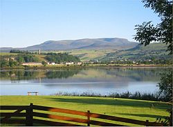
Alcaig (Old Norse which means Auk Bay: Alcaig) is a village located close to Conon Bridge in Dingwall, Ross-shire in Highland, and is within the Scottish council area of Highland. [1] [2]

Related Research Articles

Burcott, Bierton, Buckinghamshire Human settlement in England

Burcott is a hamlet in the parish of Bierton with Broughton, Buckinghamshire, England.

Dunnet Head

Dunnet Head is a peninsula in Caithness, on the north coast of Scotland. Dunnet Head includes the most northerly point of both mainland Scotland and the island of Great Britain.

Culbokie Human settlement in Scotland

Culbokie is a small village in Ross and Cromarty, Highland, Scotland. It is located on the north side of the Black Isle. The village is 3 miles (5 km) south-east of Dingwall and about 9 miles (14 km) north of Inverness.

Dornoch Firth

The Dornoch Firth is a firth on the east coast of Highland, in northern Scotland. It forms part of the boundary between Ross and Cromarty, to the south, and Sutherland, to the north. The firth is designated as a national scenic area, one of 40 such areas in Scotland. The national scenic area covers 15,782 ha in total, of which 4,240 ha is the marine area of the firth below low tide. A review of the national scenic areas by Scottish Natural Heritage in 2010 commented:

By comparison with other east coast firths the Dornoch Firth is narrow and sinuous, yet it exhibits within its compass a surprising variety of landscapes. It is enclosed by abrupt rounded granitic hills clad in heather moor and scree, their Gaelic names of cnoc, meall and creag giving the clue to their character. Their lower slopes are frequently wooded, oakwoods being a noticeable feature of the area, but with other deciduous and coniferous species represented in plantations which vary from the policy plantings of Skibo Castle to the pines of the Struie Forest.

Aston Mullins Human settlement in England

Aston Mullins is a hamlet in the parish of Dinton, in Buckinghamshire, England. At the 2011 Census the population of the hamlet was included in the civil parish of Dinton-with-Ford and Upton

Barmpton Human settlement in England

Barmpton is a small village and civil parish in the borough of Darlington and the ceremonial county of County Durham, England. The population taken at the 2011 Census was less than 100. Details are maintained in the parish of Great Burdon. It is situated a short distance to the north-east of Darlington, on the River Skerne, a tributary of the Tees.

Achriabhach Human settlement in Scotland

Achriabhach is a hamlet in Glen Nevis, Lochaber, Highland, Scotland.

Beaworthy Human settlement in England

Beaworthy is a village and civil parish in the West Devon district of Devon, England. According to the 2001 census it had a population of 236.

Morvern Human settlement in Scotland

Morvern, historically also spelt Morven, is a peninsula and traditional district in the Highlands, on the west coast of Scotland. It lies south of the districts of Ardgour and Sunart, and is bounded on the north by Loch Sunart and Glen Tarbert, on the south east by Loch Linnhe and on the south west by the Sound of Mull. The name is derived from the Gaelic A' Mhorbhairne. The highest point is the summit of the Corbett Creach Bheinn which reaches 853 metres (2,799 ft) in elevation.

Gosford and Water Eaton is a civil parish in the Cherwell district of the county of Oxfordshire, England. It is north of the city of Oxford and is crossed nearby by two major roads for, or by-passing, the city. The parish contains the village of Gosford and the hamlet of Water Eaton and as at the 2011 census had 1373 people resident across its 8.75km².

Ardmolich Human settlement in Scotland

Ardmolich and Kinlochmoidart are settlements at the east head of Loch Moidart in the Moidart region, Highland, Scotland and are in the Scottish council area of Highland.

Auchinleish Human settlement in Scotland

Auchinleish is a village in Angus, Scotland.

Aultiphurst Human settlement in Scotland

Aultiphurst, in Strathy, Sutherland, is a village in the Scottish Highlands

Farr, Sutherland Human settlement in Scotland

Farr is a parish in the county of Sutherland in the Scottish council area of Highland. The parish also includes a small hamlet named Farr. The village of Bettyhill lies less than 1 mile to the west of the hamlet along the A836 road.

The Cromarty and Dingwall Light Railway was a never-completed light railway linking Cromarty in the Black Isle, Ross and Cromarty, Scotland to the Highland Railway system at Conon.

Garbh Uisge

Garbh Uisge is a river of approximately 7 km in the Trossachs of Scotland just north-west Callander. It is the outflow of Loch Lubnaig and joins with Eas Gobhain west of Callander to form the River Teith. The name of the river, Garbh Uisge, is Gaelic for "Rough Water", reflecting the nature of the river. The river is often informally called the River Leny due to the Falls of Leny, where the river crosses the Highland Boundary Fault, and because it flows through the Pass of Leny.

Ordnance Survey National mapping agency of the UK for Great Britain

Ordnance Survey (OS) is the national mapping agency for Great Britain. The agency's name indicates its original military purpose, which was to map Scotland in the wake of the Jacobite rising of 1745. There was also a more general and nationwide need in light of the potential threat of invasion during the Napoleonic Wars. Since 1 April 2015 Ordnance Survey has operated as Ordnance Survey Ltd, a government-owned company, 100% in public ownership. The Ordnance Survey Board remains accountable to the Secretary of State for Business, Energy and Industrial Strategy. It was also a member of the Public Data Group.

Ardmore, Easter Ross Human settlement in Scotland

Ardmore is a village on the south shore of Dornoch Firth in Tain, Ross-shire, Highland and is in the Scottish council area of Highland.

Cranachan, Lochaber Human settlement in Scotland

Cranachan is a farmstead about 2.5 miles north-east of Roybridge in Lochaber, in the Highlands, Scotland. Cranachan is in the Highland Council area and stands on the north bank of the confluence of the River Roy and the River Allt Glas Dhoire.

Kinlochard Village in Scotland

Kinlochard is a village in Stirling, Scotland. It lies to the western end of Loch Ard. Children in Kinlochard attend Aberfoyle Primary School and eventually McLaren High School.

References

  1. Ordnance Survey: Landranger map sheet 26 Inverness & Loch Ness (Strathglass) (Map). Ordnance Survey. 2011. ISBN   9780319231128.
  2. "Ordnance Survey: 1:50,000 Scale Gazetteer" (csv (download)). www.ordnancesurvey.co.uk. Ordnance Survey. 1 January 2016. Retrieved 30 January 2016.