
North Yorkshire is a ceremonial county in the Yorkshire and the Humber and North East regions of England. It borders County Durham to the north, the North Sea to the east, the East Riding of Yorkshire to the south-east, South Yorkshire to the south, West Yorkshire to the south-west, and Cumbria and Lancashire to the west. Northallerton is the county town. The county was historically part of Yorkshire.

Middlesbrough is a town in North Yorkshire, England. The town lies near the mouth of the River Tees, forming part of the Teesside built-up area, and is located north of the North York Moors National Park. The wider Borough of Middlesbrough had a population 148,215 at the 2021 UK census. Middlesbrough is the largest town of the wider urban Tees Valley area, which had a population of 678,400 in 2021.

Teesside is a built-up area around the River Tees in North East England, split between County Durham and North Yorkshire. The area contains the towns of Middlesbrough, Stockton-on-Tees, Billingham, Redcar, Thornaby-on-Tees, and Ingleby Barwick. Teesside's economy was once dominated by heavy manufacturing until deindustrialisation in the latter half of the 20th century. Chemical production continues to contribute significantly to Teesside's economy.

Tees Valley is a combined authority area in Northern England, around the lower River Tees. The area is not a geographical valley; the local term for the valley is Teesdale. The combined authority covers five council areas: Darlington, Hartlepool, Middlesbrough, Redcar and Cleveland and Stockton-on-Tees.

Marton or Marton-in-Cleveland is an area of Middlesbrough, North Yorkshire, England. Until the 1950s, it was a small village next to the hamlet of Tollesby in Yorkshire's North Riding.

The Esk Valley Line is a railway line located in the north of England, covering a total distance of approximately 35 miles (56 km), running from Middlesbrough to Whitby. The line follows the course of the River Esk for much of its eastern half.

Middlesbrough College, located on one campus at Middlehaven, Middlesbrough, North Yorkshire, England, is the largest college on Teesside.

Middlesbrough is a railway station on the Durham Coast Line, Esk Valley Line and Tees Valley Line. The station serves the town of Middlesbrough in North Yorkshire, England. It is owned by Network Rail and managed by TransPennine Express. Direct destinations include Darlington, Saltburn, Sunderland, Newcastle, York, and Manchester Airport. There is a direct service to London Kings Cross once per weekday.

Teesside Park is a retail and leisure park in Thornaby-on-Tees, built in 1988. Located just off the A66 near the A66/A19 interchange, it is split between the unitary authorities of Stockton-on-Tees and Middlesbrough with the line of the Old River Tees, which runs down the middle of the development, forming the boundary between the two authorities. The development has a central building that was constructed in 2008.
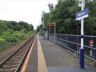
Marton is a railway station on the Esk Valley Line, which runs between Middlesbrough and Whitby via Nunthorpe. The station, situated 2 miles 79 chains (4.8 km) south-east of Middlesbrough, serves the suburbs of Marton, Middlesbrough and Ormesby, Redcar and Cleveland in North Yorkshire, England. It is owned by Network Rail and managed by Northern Trains.

Middlesbrough Council, also known as Middlesbrough Borough Council, is the local authority for Middlesbrough, in the ceremonial county of North Yorkshire, England. Since 1996 it has been a unitary authority, being a district council which also performs the functions of a county council. The council is led by the directly elected Mayor of Middlesbrough.

Nunthorpe is a village and civil parish in the Borough of Middlesbrough in North Yorkshire, England.

The Cleveland Hills are a range of hills on the north-west edge of the North York Moors in North Yorkshire, England, overlooking Cleveland and Teesside. They lie entirely within the boundaries of the North York Moors National Park. Part of the 110-mile (177 km) long Cleveland Way National Trail runs along the hills, and they are also crossed by a section of Wainwright's Coast to Coast Walk. The hills, which rise abruptly from the flat Tees Valley to the north, include distinctive landmarks such as the cone-shaped peak of Roseberry Topping, near the village of Great Ayton – childhood home of Captain James Cook.

The A172 is a major road in North Yorkshire, and the unitary authority of Middlesbrough, England. It runs from Ingleby Arncliffe to Middlesbrough. The road derives its adumbrated number from 1969 when a thoroughfare link connected South Teesside with the Lackenby Docks in Middlesbrough. Since further urban infrastructure development it has been extended into the North Yorkshire Moors, when it transforms into A174.

The Tees Valley Metro was a project to upgrade the Tees Valley Line and sections of the Esk Valley Line and Durham Coast Line to provide a faster and more frequent service across the North of England. In the initial phases the services would have been heavy rail mostly along existing alignments. The later phase would have introduced tram-trains to allow street running. The project was backed by all the local authorities through which the system would have run: Darlington, Hartlepool, Middlesbrough, Redcar & Cleveland and Stockton-on-Tees. Support was also forthcoming from the Department for Transport. The project was cancelled due to lack of funding, with the focus moving to the Northern Rail franchise. Of the original Tees Valley Metro project, only the construction of a new station at James Cook University Hospital has come to fruition.

James Cook is a railway station on the Esk Valley Line, which runs between Middlesbrough and Whitby via Nunthorpe. The station, situated 2 miles 24 chains (3.7 km) south-east of Middlesbrough, serves James Cook University Hospital and the suburbs of Berwick Hills and Park End, Middlesbrough in North Yorkshire, England. It is owned by Network Rail and managed by Northern Trains.

Tees Marshalling Yard is a railway marshalling yard, used to separate railway wagons, located near Middlesbrough in North Yorkshire, Northern England.

Stokesley railway station was a railway station built to serve the town of Stokesley in North Yorkshire, England. The station was on the North Yorkshire and Cleveland line between Sexhow and Ingleby, which opened in 1857. The line was extended progressively until it met the Whitby & Pickering Railway at Grosmont. It was closed in 1954 to passengers and eleven years later to goods. The station was located 16 miles (26 km) south of Stockton and 3.5 miles (5.6 km) west of Battersby station.
The Borough of Middlesbrough is a local government district with borough status in the ceremonial county of North Yorkshire, England, based around the town of Middlesbrough in the north of the county. Since 1996, its council, Middlesbrough Council, has been a unitary authority. The borough is part of the Tees Valley Combined Authority, along with the boroughs of Stockton-on-Tees, Redcar and Cleveland, Hartlepool and Darlington. There are two parish councils in the area of the borough of Middlesbrough, Nunthorpe and Stainton and Thornton respectively.