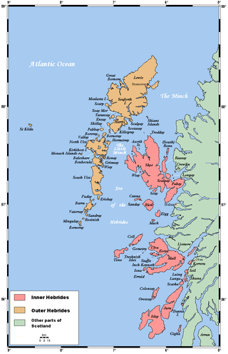
The Hebrides are an archipelago off the west coast of the Scottish mainland. The islands fall into two main groups, based on their proximity to the mainland: the Inner and Outer Hebrides.
The Outer Hebrides or Western Isles, sometimes known as the Long Isle or Long Island, is an island chain off the west coast of mainland Scotland. The islands are geographically coextensive with Comhairle nan Eilean Siar, one of the 32 unitary council areas of Scotland. They form part of the archipelago of the Hebrides, separated from the Scottish mainland and from the Inner Hebrides by the waters of the Minch, the Little Minch, and the Sea of the Hebrides.
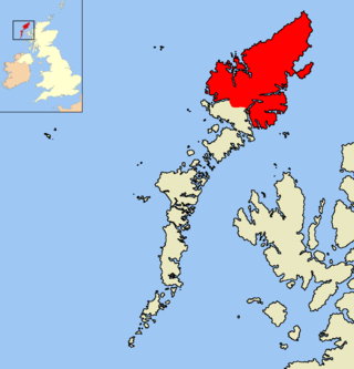
The Isle of Lewis or simply Lewis is the northern part of Lewis and Harris, the largest island of the Western Isles or Outer Hebrides archipelago in Scotland. The two parts are frequently referred to as if they were separate islands. The total area of Lewis is 683 square miles (1,770 km2).

Harris is the southern and more mountainous part of Lewis and Harris, the largest island in the Outer Hebrides, Scotland. Although not an island itself, Harris is often referred to in opposition to the Isle of Lewis as the Isle of Harris, which is the former postal county and the current post town for Royal Mail postcodes starting HS3 or HS5.

Ross and Cromarty, also referred to as Ross-shire and Cromartyshire, is a variously defined area in the Highlands and Islands of Scotland. There is a registration county and a lieutenancy area in current use, the latter of which is 8,019 square kilometres in extent. Historically there has also been a constituency of the Parliament of the United Kingdom, a local government county, a district of the Highland local government region and a management area of the Highland Council. The local government county is now divided between two local government areas: the Highland area and Na h-Eileanan Siar. Ross and Cromarty border Sutherland to the north and Inverness-shire to the south.

Caledonian MacBrayne, usually shortened to CalMac, is the major operator of passenger and vehicle ferries, and ferry services, between the mainland of Scotland and 22 of the major islands on Scotland's west coast. Since 2006, the company's official name has been CalMac Ferries Ltd, although it still operates as Caledonian MacBrayne. In 2006, it became a subsidiary of holding company David MacBrayne, which is owned by the Scottish Government.

Stornoway is the main town of the Western Isles and the capital of Lewis and Harris in Scotland.

Kyle of Lochalsh is a village in the historic county of Ross & Cromarty on the northwest coast of Scotland, located around 55 miles (90 km) west-southwest of Inverness. It is located on the Lochalsh peninsula, at the entrance to Loch Alsh, opposite the village of Kyleakin on the Isle of Skye. A ferry used to connect the two villages until it was replaced by the Skye Bridge, about a mile (2 km) to the west, in 1995.
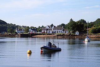
Isleornsay is a village lying off the main Armadale to Sleat road on the Isle of Skye in Scotland. It overlooks, but is not upon, the island of Ornsay. The island itself shelters one of the best natural harbours in southern Skye. The location was exploited from the 18th century or earlier by the MacDonalds who owned this part of Skye.

The Caledonian MacBrayne fleet is the largest fleet of car and passenger ferries in the United Kingdom, with 34 ferries in operation, 2 on charter and another 6 on order. The company provides lifeline services to 23 islands off the west coast of Scotland, as well as operating routes in the Firth of Clyde.

Lewis Camanachd (Scottish Gaelic: Comann Camanachd Leòdhais is the senior shinty team from the Isle of Lewis, Scotland. The club entered North Division Three for the first time in 2011. This was the first time a team from the Western Isles was allowed to compete in league shinty. However, the club was only allowed in on trial and awaited a decision from the Camanachd Association as to whether this was to become a permanent arrangement. Lewis was granted entry on a permanent basis from 2012.

MV Lord of the Isles is one of the larger Caledonian MacBrayne vessels and operates from Mallaig on the west of Scotland. Built in Port Glasgow, she is the most-travelled vessel in the CalMac fleet.
Uist Camanachd is a shinty team from the Western Isles, Scotland. The club is based in North Uist but draws its players from the whole archipelago from Berneray to Eriskay.

MV Hebrides is a ferry operated by Caledonian MacBrayne from Uig to Lochmaddy and Tarbert, the main settlements of North Uist and Harris respectively.

MV Hebridean Isles is a ro-ro vehicle ferry operated by Caledonian MacBrayne on the west coast of Scotland. She was the first MacBrayne vessel to be ordered and built for them outside Scotland and the first to be launched sideways. With bow, stern and side ramps, Hebridean Isles is suitable for all the routes served by the large fleet units. After 15 years crossing the Little Minch on the Uig triangle, she now serves Islay and Colonsay.

MV Isle of Arran is a drive-through ferry operated on the west coast of Scotland by Caledonian MacBrayne. Entering service in 1984, she served on the Arran route for nine years before being moved to Kennacraig. She returned to her original route in 2012, supplementing MV Caledonian Isles in summer and becoming a relief vessel in winter. In 2013, she started a new pilot route from Ardrossan to Campbeltown, which became a permanent fixture in 2015. As of 2023, she is one of the oldest vessels in the fleet, having been in service for 39 years.

Lewis and Harris, or Lewis with Harris, is a single Scottish island in the Outer Hebrides, divided by mountains. It is the largest island in Scotland and the third largest in the British Isles, after Great Britain and the island of Ireland, with an area of 841 square miles (2,178 km2), which is approximately 1% of the area of Great Britain. The northern two-thirds is called [the Isle of] Lewis and the southern third [the Isle of] Harris; each is referred to as if it were a separate island and there are many cultural and linguistic differences between the two.

MV Hebridean Princess is a cruise ship operated by Hebridean Island Cruises. She started life as the MacBrayne car ferry and Royal Mail Ship, initially RMS then MV Columba, based in Oban for the first 25 years of her life, carrying up to 600 passengers, and 50 cars, between the Scottish islands.
The Skye Marble Railway was a 3 ft narrow gauge industrial railway on the Isle of Skye, Scotland which operated from 1910 to 1912.

Stornoway power station, also known as Battery Point Power Station, is an electrical generation facility in Stornoway, Scotland. It was commissioned in 1954 to supply power to the Western Isles and currently comprises eight Mirrlees Blackstone, medium speed, diesel generators with a combined output of 25.5MW. The station is owned and operated by Scottish and Southern Electricity Networks (SSEN) part of SSE plc. The Western Isles power network was originally operated independently of the Scottish mainland network.