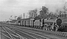
Thameslink is a mainline route on the British railway network, running from Bedford, Luton, St Albans City, Peterborough, Welwyn Garden City, London Blackfriars and Cambridge via central London to Sutton, Orpington, Sevenoaks, Rainham, Horsham, Three Bridges, Brighton and East Grinstead. The network opened as a through service in 1988, with severe overcrowding by 1998, carrying more than 28,000 passengers in the morning peak. All the services are currently operated by Govia Thameslink Railway. Parts of the network, from Bedford to Three Bridges, run 24 hours a day, except on early Sunday mornings and during maintenance periods.

Flitwick is a town and civil parish in Central Bedfordshire, England. It is mentioned in the Domesday Book of 1086 as "a hamlet on the River Flitt". The spelling Flytwyk appears in 1381.

St Pancras railway station, officially known since 2007 as London St Pancras International, is a major central London railway terminus on Euston Road in the London Borough of Camden. It is the terminus for Eurostar services from Belgium, France and the Netherlands to London. It provides East Midlands Railway services to Leicester, Corby, Derby, Sheffield and Nottingham on the Midland Main Line, Southeastern high-speed trains to Kent via Ebbsfleet International and Ashford International, and Thameslink cross-London services to Bedford, Cambridge, Peterborough, Brighton, Horsham and Gatwick Airport. It stands between the British Library, the Regent's Canal and London King's Cross railway station, with which it shares a London Underground station, King's Cross St Pancras.

King's Cross Thameslink station is a closed railway station in central London, England. It is located on Pentonville Road, around 250 metres (0.2 mi) east of King's Cross mainline station. At the time of closure, in 2007, it was served by Thameslink trains and managed by First Capital Connect. Services have been transferred to a new station underneath St Pancras.

Hendon railway station is on the Midland Main Line in England, in West Hendon in the London Borough of Barnet, north London. It is 6 miles 79 chains (11.2 km) down the line from St Pancras and is situated between Brent Cross West to the south and Mill Hill Broadway to the north. Its three-letter station code is HEN.
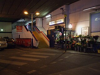
Mill Hill Broadway railway station is on the Midland Main Line in England, serving the suburb of Mill Hill in the London Borough of Barnet, north London. It is 9 miles 28 chains (15.0 km) down the line from St Pancras and is situated between Hendon to the south and Elstree & Borehamwood to the north. Its three-letter station code is MIL.

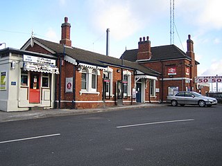
Elstree & Borehamwood railway station is a railway station in the town of Borehamwood, Hertfordshire, England. It primarily serves Borehamwood as well as the nearby village of Elstree, 1.3 miles (2.1 km) to the south-west. The station is situated on the Midland Main Line, 12 miles 35 chains (20.0 km) down the line from London St Pancras and is situated between Mill Hill Broadway to the south and Radlett to the north. Its three-letter station code is ELS.

Bedford railway station is the larger of two railway stations in the town of Bedford in Bedfordshire, England. It is on the Midland Main Line from London St Pancras to the East Midlands and the terminus of the Marston Vale line from Bletchley through Bedford St Johns.

Harlington is a village and civil parish located in Bedfordshire, England, near the M1 motorway. The nearest town is Flitwick about 3 miles (4.8 km) to the north.

Harlington railway station is located in Bedfordshire. It is named after the village of Harlington, on the outskirts of which it is located, but serves a wide rural area including the larger villages of Toddington and Barton-le-Clay.

Luton Airport Parkway station is on the Midland Main Line in England, serving south Luton and Luton Airport in Bedfordshire. The station is situated in Luton's Park Town district, being 29.27 miles (47.11 km) from London St Pancras between Harpenden to the south and Luton to the north. Its three-letter station code is LTN, also the IATA code for the airport.

Luton railway station is located in the town centre of Luton, Bedfordshire, England. The station is about three minutes' walk from The Mall Shopping Centre. It is situated on the Midland Main Line and is operated by Thameslink.

St Albans City railway station, also known simply as St Albans, is one of two railway stations serving the city of St Albans in Hertfordshire, England. The 'City' station is the larger of the two, as it is on the better-connected Midland Main Line 19 miles 71 chains (32.0 km) from London St Pancras, being served by Govia Thameslink trains on the Thameslink route.

West Hampstead Thameslink is a National Rail station on the Midland Main Line and is served by Thameslink trains as part of the Thameslink route between Kentish Town and Cricklewood. The station is in Travelcard Zone 2.
Leagrave railway station is located in Leagrave, a suburb in the north of Luton in Bedfordshire, England. Leagrave station is situated on the Midland Main Line 33¾ miles (54 km) north of London St Pancras International. The station is managed by Govia Thameslink Railway, and is served by the Thameslink route.

Radlett railway station is on the Midland Main Line in England, serving the village of Radlett, Hertfordshire. It is 15 miles 17 chains (24.5 km) down the line from London St Pancras and is situated between Elstree & Borehamwood to the south and St Albans City to the north. Its three-letter station code is RDT.

Harpenden railway station is on the Midland Main Line in England, serving the town of Harpenden, Hertfordshire. It is 24 miles 51 chains (39.7 km) down the line from London St Pancras and is situated between St Albans City to the south and Luton Airport Parkway to the north. Its three-letter station code is HPD.

Glendon and Rushton railway station is a Grade II listed former railway station in Rushton, Northamptonshire.

Southill was a railway station on the Bedford to Hitchin Line which served the village of Southill in Bedfordshire, England. Opened in 1857, it gave more than a century of service before closing in 1962.
Transport in Bedford provides links between the town and other parts of England. Road access to and from the town is provided by the A6 and A421 roads; the former connects the town with Kettering to the north-west, and Luton to the south, whilst the latter connects the town with Milton Keynes and the M1 to the west, and the A1 to the east via a bypass, with both being around 10 miles (16 km) away. Other roads that serve or skirt the town include the A422, which runs westwards into Milton Keynes, and the A428, which runs between Coventry and Cambridge.