Related Research Articles

Hawke's Bay is a region on the east coast of New Zealand's North Island. The region is named for Hawke Bay, which was named in honour of Edward Hawke. The region's main centres are the cities of Napier and Hastings, while the more rural parts of the region are served by the towns of Waipukurau, Waipawa, and Wairoa.
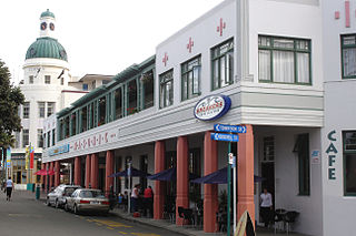
Napier is a city on the eastern coast of the North Island of New Zealand and the seat of the Hawke's Bay region. It is a beachside city with a seaport, known for its sunny climate, esplanade lined with Norfolk pines, and extensive Art Deco architecture. For these attributes, Napier is sometimes romantically referred to as the "Nice of the Pacific".

The 1931 Hawke's Bay earthquake, also known as the Napier earthquake, occurred in New Zealand at 10:47 am on 3 February, killing 256, injuring thousands and devastating the Hawke's Bay region. It remains New Zealand's deadliest natural disaster. Centred 15 km north of Napier, it lasted for two and a half minutes and had a magnitude of 7.8 Ms. There were 525 aftershocks recorded in the following two weeks, with 597 being recorded by the end of February. The main shock could be felt in much of New Zealand, with reliable reports coming in from as far south as Timaru, on the east coast of the South Island.

Hastings is an inland city of New Zealand and is one of the two major urban areas in Hawke's Bay, on the east coast of the North Island. The population of Hastings is 52,200, with a further 14,900 people in Havelock North and 2,120 in Clive. Hastings is about 18 kilometres inland of the coastal city of Napier. These two neighbouring cities are often called "The Bay Cities" or "The Twin Cities".

Gisborne is a city in northeastern New Zealand and the largest settlement in the Gisborne District. It has a population of 38,800. Gisborne District Council has its headquarters in the central city.

Wairoa is the largest town in the Wairoa District and the northernmost town in the Hawke's Bay region of New Zealand's North Island. It is located on the northern shore of Hawke Bay at the mouth of the Wairoa River and to the west of Māhia Peninsula. It is 118 kilometres (73 mi) northeast of Napier, and 92 kilometres (57 mi) southwest of Gisborne, on State Highway 2. It is the nearest town to the Te Urewera protected area and former national park, which is accessible from Wairoa via State Highway 38. It is one of three towns in New Zealand where Māori outnumber other ethnicities, with 62.29% of the population identifying as Māori.

The Napier-Hastings Urban Area was defined by Statistics New Zealand as a main urban area of New Zealand that was based around the twin cities of Napier and Hastings in the Hawke's Bay Region. It was defined under the New Zealand Standard Areas Classification 1992 (NZSAC92), which has since been superseded by the Statistical Standard for Geographic Areas 2018 (SSGA18).
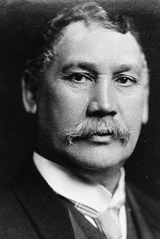
Sir James Carroll, was a New Zealand politician. Beginning his career as an interpreter and land agent, Carroll was elected to the Eastern Maori seat in 1887. He was acting colonial secretary from 1897 to 1899. He was the first Māori to hold the cabinet position of Minister of Native Affairs, which he held between 1899 and 1912. He was held in high regard within the Liberal Party and was acting prime minister in 1909 and 1911.

The Wairoa River of the Hawke's Bay region in New Zealand runs south for 65 kilometres from the inland east coast region of the North Island, west of Gisborne, before flowing into northern Hawke Bay at the town of Wairoa.
The Palmerston North–Gisborne Line (PNGL) is a secondary main line railway in the North Island of New Zealand. It branches from the North Island Main Trunk at Palmerston North and runs east through the Manawatū Gorge to Woodville, where it meets the Wairarapa Line, and then proceeds to Hastings and Napier in Hawke's Bay before following the coast north to Gisborne. Construction began in 1872, but the entire line was not completed until 1942. The line crosses the runway of Gisborne Airport, one of the world's few railways to do so since Pakistan's Khyber Pass Railway closed.

Gisborne District or the Gisborne Region is a local government area of northeastern New Zealand. It is governed by Gisborne District Council, a unitary authority. It is named after its largest settlement, the city of Gisborne. The region is also commonly referred to as the East Coast.

The Mangapōike River is a river beginning in the Gisborne Region of New Zealand's North Island. It flows generally southwest from sources south of Waingake, reaching the Wairoa River in Hawke's Bay 10 kilometres (6 mi) northeast of Frasertown. Mangapōike River was Gazetted as an official name on 28 November 2022.

Wairoa District is a territorial authority district within the Hawke's Bay Region in the North Island of New Zealand. The Wairoa District Council is headquartered in the largest town, Wairoa. The district covers the northern half of the Hawke's Bay coast, extending from Māhia Peninsula to Lake Waikaremoana, and south to the mouth of the Waikare River.

The Mohaka Viaduct is a railway viaduct spanning the Mohaka River in northern Hawke’s Bay, on the East Coast of the North Island of New Zealand, near the small settlement of Raupunga. It was built between 1930 and 1937 by the Public Works Department (PWD) for the New Zealand Railways Department (NZR). It is 276.8 metres (908 ft) in length, and at 95 metres (312 ft), is the tallest viaduct in Australasia.
Awatoto is a coastal suburb area within the city of Napier, Hawke's Bay, New Zealand. It stretches along the coast south of Te Awa and the central city. The northern part of Awatoto is residential, while the southern part is industrial, including heavy industry.
The Mayor of Central Hawke's Bay officiates over the Central Hawke's Bay District Council.

The Mayor of Wairoa officiates over the Wairoa District Council.

Severe Tropical Cyclone Gabrielle was a destructive tropical cyclone that devastated parts of the North Island of New Zealand and affected parts of Vanuatu and Australia in February 2023. It is the costliest tropical cyclone on record in the Southern Hemisphere, with total damage estimated to be NZ$14.5 billion (US$9.2 billion), in which NZ$3.18 billion (US$2 billion) are insurance loss. It was also the deadliest cyclone and weather event overall to hit New Zealand since Cyclone Giselle in 1968, surpassing Cyclone Bola in 1988. The fifth named storm of the 2022–23 Australian region cyclone season, and the first severe tropical cyclone of the 2022–23 South Pacific cyclone season, Gabrielle was first noted as a developing tropical low on 6 February 2023, while it was located on the south of the Solomon Islands, before it was classified as a tropical cyclone and named Gabrielle by the Bureau of Meteorology. The system peaked as a Category 3 severe tropical cyclone before moving into the South Pacific basin, then rapidly degenerated into a subtropical low on 11 February 2023.

In early October 2024, the Otago region of New Zealand's South Island experienced heavy rainfall and significant flooding and landslides. The weather event affected coastal areas in Otago including North Otago, Dunedin, and the Clutha District, which received an estimated two-months worth of rainfall between 2 and 4 October. On 3 October, a state of emergency was declared in Dunedin, with residents in some low-lying suburbs being told to evacuate. By 4 October, the Clutha District had also declared a state of emergency. By 6 October, the state of emergency in Dunedin and Clutha had been lifted due to improving weather conditions and floodwaters subsiding.
References
- ↑ "Live weather updates: Evacuations in parts of Tai Rāwhiti, Hawke's Bay". RNZ . 26 June 2024. Archived from the original on 26 June 2024. Retrieved 26 June 2024.
- ↑ "East Coast flooding: Rain to fall for days, but the worst is over, forecasters say". RNZ . 26 June 2024. Archived from the original on 26 June 2024. Retrieved 26 June 2024.
- ↑ "East Coast floods: Tragic week to linger long after waters recede, MP says". RNZ . 28 June 2024. Archived from the original on 30 June 2024. Retrieved 1 July 2024.
- 1 2 "Wairoa flooding: Locals can't afford $40 million clean-up bill - mayor". Radio New Zealand. 30 June 2024. Archived from the original on 30 June 2024. Retrieved 1 July 2024.
- ↑ "Hawke's Bay flood protection works". Ministry for the Environment. 7 June 2024. Archived from the original on 6 July 2024. Retrieved 6 July 2024.
- ↑ "Heavy rain warnings for Gisborne and Hawke's Bay". RNZ . 25 June 2024. Archived from the original on 25 June 2024. Retrieved 6 July 2024.
- 1 2 "As it happened: Evacuations in parts of Tai Rāwhiti, Hawke's Bay". RNZ . 26 June 2024. Archived from the original on 1 July 2024. Retrieved 6 July 2024.
- 1 2 3 4 5 "Running from the water again in Hawke's Bay: The morning when angry seas and creaking rivers met". Hawke's Bay Today . The New Zealand Herald. 26 June 2024. Archived from the original on 26 June 2024. Retrieved 6 July 2024.
- 1 2 3 4 5 "East Coast flooding: Wairoa remains in state of emergency as clean-up continues; hundreds of properties flood-damaged". Hawke's Bay Today . The New Zealand Herald. 27 June 2024. Archived from the original on 2 July 2024. Retrieved 6 July 2024.
- 1 2 "Wairoa flooding: PM Christopher Luxon plans visit; families rehoused at holiday park". Hawkes Bay Today . The New Zealand Herald. 2 July 2024. Archived from the original on 4 July 2024. Retrieved 2 July 2024.
- ↑ "Flashbacks and feeling anxious: Hawke's Bay flooding will re-traumatise locals - psychologist". 1News . 2 July 2024. Archived from the original on 5 July 2024. Retrieved 2 July 2024.
- ↑ Kershaw, Eva (1 July 2024). "Wairoa flooding: Taskforce Kiwi volunteers on the ground for disaster response". The New Zealand Herald . Archived from the original on 2 July 2024. Retrieved 7 July 2024.
- ↑ "$500k flows to Wairoa flood fund". Inside Government. JSL media. 3 July 2024. Archived from the original on 7 July 2024. Retrieved 7 July 2024.
- ↑ "Government pumps a further $3m into Wairoa flood recovery". RNZ . 6 July 2024. Archived from the original on 6 July 2024. Retrieved 7 July 2024.
- ↑ Pocock, James; Hamilton-Irvine, Gary (27 June 2024). "Timeline of a flood in Wairoa: Hawke's Bay Regional Council defends decisions around river mouth opening". Hawke's Bay Today . The New Zealand Herald. Archived from the original on 2 July 2024. Retrieved 6 July 2024.
- ↑ Crimp, Lauren (2 July 2024). "External review to look into decisions made in wake of Wairoa flood". RNZ . Archived from the original on 4 July 2024. Retrieved 2 July 2024.
- ↑ Pearse, Adam (3 July 2024). "Govt launches review into Wairoa flood response, adds $500,000 to relief fund". The New Zealand Herald . Archived from the original on 13 July 2024. Retrieved 14 July 2024.
- ↑ Gabel, Julia (12 July 2024). "Wairoa floods: Urgent review will investigate regional council's management of river bar". The New Zealand Herald . Archived from the original on 13 July 2024. Retrieved 14 July 2024.
- ↑ Crimp, Lauren (11 September 2024). "Wairoa flood review finds council lacked plan and didn't listen to locals". RNZ . Archived from the original on 10 September 2024. Retrieved 10 September 2024.