Minangkabau is an Austronesian language spoken by the Minangkabau of West Sumatra, the western part of Riau, South Aceh Regency, the northern part of Bengkulu and Jambi, also in several cities throughout Indonesia by migrated Minangkabau. The language is also a lingua franca along the western coastal region of the province of North Sumatra, and is even used in parts of Aceh, where the language is called Aneuk Jamee.

Mount Merapi is an active stratovolcano located on the border between the province of Central Java and the Special Region of Yogyakarta, Indonesia. It is the most active volcano in Indonesia and has erupted regularly since 1548. It is located approximately 28 km (17 mi) north of Yogyakarta city which has a population of 2.4 million, and thousands of people live on the flanks of the volcano, with villages as high as 1,700 m (5,577 ft) above sea level.

Agam Regency is a regency of West Sumatra, Indonesia. It has an area of 2,226.27 km2 and had a population of 454,853 at the 2010 census and 529,138 at the 2020 census; the official estimate as at mid 2023 was 530,123. The regency seat is the town of Lubuk Basung. Bukittinggi city is surrounded by this regency but is not administratively included in it.

Padang Panjang, is a city located in the cool highlands of West Sumatra, inland from the provincial capital Padang. Created by Law No.12 of 1956, it is an enclave situated geographically within Tanah Datar Regency. It sits on a plateau beneath the volcanoes Mount Marapi and Mount Singgalang. It has an area of 23.0 km2 and a population at the 2010 Census of 47,008 and 56,311 at the 2020 Census; the official estimate as at mid 2023 was 58,627 - comprising 29,461 males and 29,166 females. It is located at 0°27′S100°25′E.

The Marapi, or Mount Marapi, is a complex volcano in West Sumatra, Indonesia, and is the most active volcano in Sumatra. Like that of its quasi-homonym on Java, its name means "Mountain of Fire". Its elevation is 2,885 metres (9,465.2 ft). Several cities and towns are situated around the mountain including Bukittinggi, Padang Panjang, and Batusangkar. The volcano is also popular among hikers.

Tanah Datar Regency is a landlocked regency (kabupaten) in West Sumatra province, Indonesia. The regency has an area of 1,337.1 km2 and had a population of 338,484 at the 2010 Census, which rose to 371,704 at the 2020 Census. The official estimate as of mid-2023 was 383,676 - comprising 193,190 males and 190,490 females. The regency seat is the town of Batusangkar. The city of Padang Panjang is also geographically located within the regency but constitutes a municipality of its own.

Mount Ibu is a stratovolcano at the north-west coast of Halmahera island, Indonesia. The summit is truncated and contains nested craters. The inner crater is 1 km (0.62 mi) wide and 400 m (1,312 ft) deep, while the outer is 1.2 km (0.75 mi) wide. A large parasitic cone is at the north-east of the summit and a smaller one at the south-west. The latter feeds a lava flow down the west flank. A group of maars are on the western and northern side of the volcano. Mount Ibu sits within the Pacific Ocean's "Ring of Fire" that has 127 active volcanoes.

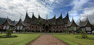
Pagaruyung Palace is the istana of the former Pagaruyung Kingdom, located in Tanjung Emas subdistrict near Batusangkar town, Tanah Datar Regency, West Sumatra, Indonesia. It was built in the traditional Minangkabau Rumah Gadang vernacular architectural style but had several atypical elements including a three-story structure and a larger dimension in comparison to common rumah gadang.

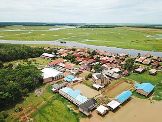
Ogan Komering Ilir Regency is a regency of South Sumatra Province, Indonesia. It takes its name from the Ogan River and the Komering River, which are the two main rivers that drain the area. The name Ilir means downstream. The administrative centre is the town of Kayu Agung. The regency borders Banyuasin Regency to the northwest, Bangka Strait, and the Java Sea to the east, Lampung Province to the south, and Palembang city, Ogan Ilir Regency, and East Ogan Komering Ulu Regency to the west.

Tour de Singkarak is an annual professional road bicycle racing stage race held in West Sumatra, Indonesia, and named after the Lake Singkarak. First staged in 2009, Tour de Singkarak is classified by the Union Cycling International (UCI) as a 2.2 category race as part of the UCI Asia Tour. It covers more than 1267 kilometres — from/to Padang passing around lake Singkarak and runs through inland West Sumatran cities — and lasted for a week and held annually. This exciting tour across the picturesque West Sumatra countryside's scenic landscapes, comprising beaches, blue lakes, and numerous hairpin bends, as they climb up to the foot of the volcanoes. The total prize money is IDR 1,000,000,000 (US$100,000). BNI-Maybank was the platinum sponsor of the Tour De Singkarak since 2009 with the Ministry of Culture and Tourism of Indonesia. TDS is the biggest international cycling race in Indonesia, having the fifth largest audience in the world, it attracted many top international cyclists to participate in this world famous annual sports event.

The Minangkabau Highlands is a mountainous area in the province of West Sumatra, located around three mountains—Mount Marapi, Mount Singgalang, and Mount Sago—in west-central Sumatra, Indonesia. The highlands are part of the Barisan Mountains, the largest mountain range in Sumatra. They are home to the Minangkabau people who refer to the area as Alam Minangkabau, or "the world of Minangkabau". This area formed a kingdom known from at least the 7th century as Malayu.

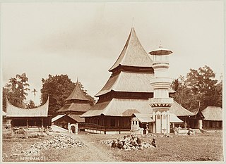
Grand Mosque of Kubang Putih is an early 19th-century mosque located in the town of Kubang Putiah, West Sumatra, Indonesia. The mosque is designated as a cultural heritage object along with several other old mosques in West Sumatra, such as Bingkudu Mosque in Agam, Rao Rao Mosque in Tanah Datar, and the Ganting Grand Mosque in Padang.

The pacu jawi is a traditional bull race in Tanah Datar, West Sumatra, Indonesia. In the race, a jockey stands on a wooden plough loosely tied to a pair of bulls and holds them by their tails while the bulls cover about 60–250 metres (200–820 ft) of muddy track in a rice field. Although the name means a "bull race", the bulls do not directly compete against each other, and no formal winner is declared. Instead, spectators judge the bulls by their performance, and have the ability to buy well-performing bulls, albeit at well above usual price. The people of Tanah Datar—especially the nagaris (villages) in four of its districts—have been conducting this tradition for centuries to celebrate the end of the rice harvest. The race is held concurrently with a village festival of culture called alek pacu jawi. Recently it has become a tourist attraction supported by the government and the subject of multiple award-winning photographs.

The West Sumatra Regional House of Representatives is the unicameral legislative body within the regional government of the Indonesian province of West Sumatra. The council is composed of 65 members elected via party lists in the 2019 general election.

Indonesia is an island country in Southeast Asia and Oceania, located in the Pacific Ocean and the Indian Ocean. The largest island nation in the world, the country is the home of over seventeen thousand islands.

An eruption of Mount Semeru, a volcano in East Java province of the Indonesian island of Java, began on 4 December 2021. The eruption began after heavy precipitation caused the collapse of the lava dome at the summit. Pyroclastic flows and lahars damaged at least 5,205 homes and several public buildings. At least 69 people died, 104 more were injured, while more than five remain missing.

On 25 February 2022 at 08:39 WIB, a moment magnitude (Mw ) 6.2 earthquake struck West Sumatra, Indonesia at a depth of 4.0 km (2.5 mi). Preceded by one foreshock and followed by over 200 aftershocks, the mainshock had an epicenter at the foot of Mount Talakmau in Pasaman Regency. The mainshock was the result of strike-slip faulting along a previously unidentified segment of the Great Sumatran Fault. At least 27 people died, 457 were injured, and 19,221 others were displaced. It inflicted 780 million Indonesian rupiahs (Rp) worth of damage. The heaviest damage was recorded at three villages around Mount Talakmau. Landslides and flash floods caused additional damage and casualties.
From 7 March 2024 to 13 March 2024, flash floods and landslides in Sumatra, Indonesia killed 26 people, and caused Rp170.4 billion in damages. The floods were caused by higher-than-normal rainfall.


