
Hawke's Bay is a region on the east coast of New Zealand's North Island. The region is named for Hawke Bay, which was named in honour of Edward Hawke. The region's main centres are the cities of Napier and Hastings, while the more rural parts of the region are served by the towns of Waipukurau, Waipawa, and Wairoa.

Wairoa is the largest town in the Wairoa District and the northernmost town in the Hawke's Bay region of New Zealand's North Island. It is located on the northern shore of Hawke Bay at the mouth of the Wairoa River and to the west of Māhia Peninsula. It is 118 kilometres (73 mi) northeast of Napier, and 92 kilometres (57 mi) southwest of Gisborne, on State Highway 2. It is the nearest town to the Te Urewera protected area and former national park, which is accessible from Wairoa via State Highway 38. It is one of three towns in New Zealand where Māori outnumber other ethnicities, with 62.29% of the population identifying as Māori.

Waipawa is the second-largest town in Central Hawke's Bay in the east of the North Island of New Zealand. It has a population of 2,400.

Tolaga Bay is both a bay and small town on the East Coast of New Zealand's North Island located 45 kilometres northeast of Gisborne and 30 kilometres south of Tokomaru Bay.

The Ngaruroro River is located in the eastern North Island of New Zealand. It runs for a total of 164 kilometres southeast from the Kaweka Range, Kaimanawa Range and Ruahine Range and then east before emptying into Hawke Bay roughly halfway between the cities of Napier and Hastings, near the town of Clive. About 40% of the catchment is pasture, and 55% native forest. The meaning of Ngaruroro is obscure.
Clive is a small town, ten kilometres from the city centres of both Napier and Hastings in the Hawke's Bay region of New Zealand's North Island. It is close to the mouth of the Ngaruroro River.
Pukehou is a farming locality in southern Hawke's Bay, in the eastern North Island of New Zealand.
Bridge Pa is a rural Māori settlement and surrounding area in Hawke's Bay, New Zealand, located approximately 10 kilometres inland from Hastings. The pā itself comprises a school, a meetinghouse of the LDS Church, two marae, a cemetery, a disused quarry, and the 140-year-old historical Homestead of the Kamau family.
The Tutaekuri River flows eastward for 99.9 kilometres through the Hawke's Bay Region of the eastern North Island of New Zealand into the Pacific Ocean. It starts in the Kaweka Range roughly 50 kilometres north-east of Taihape, and reaches the sea just to the south of Napier, where the Ngaruroro and Clive Rivers join it.
Mohaka is a small settlement in the northern Hawke's Bay region of the eastern North Island of New Zealand. It is located on the coast of Hawke Bay, 20 kilometres southwest of Wairoa.
Rangitukia is a small settlement 10 kilometres south of East Cape in the northeast of New Zealand's North Island. It is near the mouth of the Waiapu River.
Tangoio is a farming locality and beach 23 kilometres north of Napier, 7 kilometres north of Whirinaki and 7 kilometres south-west of Waipatiki Beach in the Hawke's Bay Region of New Zealand's North Island. The locality is on the flat along Te Ngarue Stream and State Highway 2. It is part of Hastings District. Tangoio has been the official name since it replaced Tongoio in 1930. Near Tangoio Beach is Whakaari Headland, the site of a whaling station in the 1840s and a Maori canoe landing reserve.
Maungaharuru Tangitū is a collective of Māori hapū (subtribes) of the Ngāti Kahungunu iwi in Hawke's Bay, New Zealand, who joined forces for Treaty of Waitangi settlement negotiations. The hapū are Marangatūhetaua, Ngāi Tauira, Ngāi Te Ruruku ki Tangoio, Ngāi Tahu, Ngāti Kurumōkihi and Ngāti Whakaari. The group's rohe ranges from Bay View in the south to the Waitaha Stream in the north, and from the Maungaharuru Range in the west to the sea in Hawke Bay, that part of the sea being known as Tangitū.
Putere is a village and rural community in the Wairoa District of the Hawke's Bay Region, on New Zealand's North Island. It is located around the small Lake Rotoroa and Lake Rotonuiaha. The main road to Putere runs from Raupunga on State Highway 2.
Muriwai is a settlement and rural community at the southern end of Poverty Bay, in the Gisborne District of New Zealand's North Island, south of Manutuke. The main settlement is just west of Young Nick's Head. State Highway 2 runs through Muriwai on its way from Gisborne to Hawke's Bay.
Puketapu is a rural community in the Hastings District and Hawke's Bay Region of New Zealand's North Island.
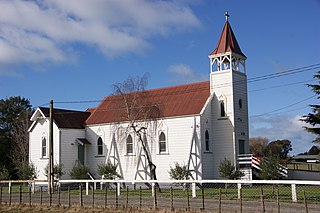
Pakipaki is a pā kāinga village and rural community in the Hastings District and Hawke's Bay Region of New Zealand's North Island. The village is home to many Ngāti Whatuiāpiti hapū tribes represented by their three marae of Houngarea, Mihiroa, and Taraia. The village is also the home of the Hawke's Bay Catholic Māori Mission and displays the Foundation Stone for the Catholic Church in Hawke's Bay. Pakipaki is a Sacred Space in the Footsteps of Venerable Suzanne Aubert.
Waipatu is a semi-rural suburb of Hastings, in the Hastings District and Hawke's Bay Region of New Zealand's North Island.
Omahu is a village in the Hastings District and Hawke's Bay Region of New Zealand's North Island. It is located on State Highway 50, north-west of Hastings on the north bank of the Ngaruroro River.
Waiaua or Lower Waiaua is a rural community in the Ōpōtiki District and Bay of Plenty Region of New Zealand's North Island, located around the lower part of the Waiaua River.
