Frimley, New Zealand

Last updated

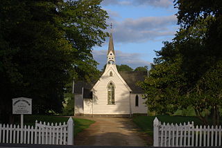
Flaxmere is a suburb of Hastings City, in the Hawke's Bay Region of New Zealand's North Island.

Hastings, New Zealand City in Hawkes Bay, New Zealand

Hastings is a New Zealand city and is one of the two major urban areas in Hawke's Bay, on the east coast of the North Island of New Zealand. The population of Hastings is 70,600, with 45,000 living in the contiguous city and Flaxmere, 13,950 in Havelock North, 2,210 in Clive, and the remainder in the peri-urban area around the city. Hastings is about 18 kilometres inland of the coastal city of Napier. These two neighbouring cities are often called "The Bay Cities" or "The Twin Cities". The combined population of the Napier-Hastings Urban Area is 134,500 people, which makes it the sixth-largest urban area in New Zealand, closely following Tauranga (141,600).

Hawkes Bay Region region on the east coast of New Zealands North Island

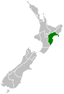
Hawke's Bay Region is a region of New Zealand on the east coast of the North Island. It is governed by Hawke's Bay Regional Council, which sits in the city of Napier. The region's name derives from Hawke Bay, which was named by Captain James Cook in honour of Admiral Edward Hawke.

North Island The northern of the two main islands of New Zealand

The North Island, also officially named Te Ika-a-Māui, is one of the two main islands of New Zealand, separated from the larger but much less populous South Island by Cook Strait. The island's area is 113,729 square kilometres (43,911 sq mi), making it the world's 14th-largest island. It has a population of 3,749,200.

The fertile land were added to the Hastings city boundary in 1957 to address a shortage of land. [1]

Education

Frimley School is a co-educational Year 1-6 state primary school, [2] [3] with a roll of 494 as of March 2019. [4] [5]

Hastings Girls' High School is a Year 9-13 girls' state secondary school, [6] [7] with a roll of 673 as of March 2019. [4] [8]

Lindisfarne College is a state-integrated Year 7-13 Catholic boys' secondary school, [9] with a roll of 527 as of March 2019. [4] [10]

Related Research Articles

Flaxmere human settlement in New Zealand

Flaxmere is a township in the Hastings District and outlying suburb of Hastings City, in the Hawke's Bay Region of New Zealand's North Island. It consists of a series of cul-de-sacs, radiating from a main street.

Napier Hill

Napier Hill is a limestone outcrop and suburb rising above the lowland districts of the city of Napier on New Zealand's North Island.

Pukehou Place in New Zealand

Pukehou is a farming locality in southern Hawke's Bay, in the eastern North Island of New Zealand.

Otane Place in New Zealand

Otane is a township in the Central Hawke's Bay District and the Hawke's Bay region, on the east coast of New Zealand's North Island. The small village, has a school, general store, cafe and pub, and is located just off State Highway 2. The community had a population of 537 as of 2013.

Onekawa is a suburb of the city of Napier, in the Hawke's Bay Region of the eastern North Island of New Zealand.

Raureka is a suburb of Hastings City, in the Hawke's Bay Region of New Zealand's North Island.

Maraenui is a suburb of the city of Napier, in the Hawke's Bay region of New Zealand's eastern North Island.

Mahora is a suburb of the city of Hastings, in the Hawke's Bay region of New Zealand's eastern North Island.

Eskdale is a rural settlement the Hastings District and Hawke's Bay Region of New Zealand's North Island. It is located north of Napier on State Highway 5, near the mouth of the Esk River.

Tamatea is a suburb of the city of Napier, in the Hawke's Bay region of New Zealand's eastern North Island.

Te Awa is a suburb of the city of Napier, in the Hawke's Bay region of New Zealand's eastern North Island.

Central Napier is the central area and business district of Napier, in the Hawke's Bay region of New Zealand's eastern North Island.

Parkvale is a suburb of Hastings City, in the Hawke's Bay Region of New Zealand's North Island.

Akina is a suburb of Hastings City, in the Hawke's Bay Region of New Zealand's North Island.

Camberley is a suburb of Hastings City, in the Hawke's Bay Region of New Zealand's North Island.

Mayfair is a suburb of Hastings City, in the Hawke's Bay Region of New Zealand's North Island.

Hastings Central is the central suburb and business district of Hastings City, in the Hawke's Bay Region of New Zealand's North Island.

Maraekakaho is a rural settlement in the Hastings District and Hawke's Bay Region of New Zealand's North Island.

Sherenden is a settlement in the Hastings District and Hawke's Bay Region of New Zealand's North Island.

Patoka is a rural community in the Hastings District and Hawke's Bay Region of New Zealand's North Island. It is located at base of the Kaweka Range and Kaweka Forest Park.

References

  1. Fowler, Michael (2 March 2019). "Historic HB: 'Parade of Homes' a great success". New Zealand Media and Entertainment. Hawke's Bay Today.
  2. "Frimley School Official School Website". frimley.school.nz.
  3. "Frimley School Ministry of Education School Profile". educationcounts.govt.nz. Ministry of Education.
  4. 1 2 3 "Directory of Schools - as at 3 April 2019". New Zealand Ministry of Education. Retrieved 9 May 2018.
  5. "Frimley School Education Review Office Report". ero.govt.nz. Education Review Office.
  6. "Hastings Girls' High School Official School Website". hastingsgirls.com.
  7. "Hastings Girls' High School Ministry of Education School Profile". educationcounts.govt.nz. Ministry of Education.
  8. "Hastings Girls' High School Education Review Office Report". ero.govt.nz. Education Review Office.
  9. "Lindisfarne College Ministry of Education School Profile". educationcounts.govt.nz. Ministry of Education.
  10. "Lindisfarne College Education Review Office Report". ero.govt.nz. Education Review Office.

Coordinates: 39°37′19″S176°49′37″E / 39.621817°S 176.826972°E / -39.621817; 176.826972

Geographic coordinate system Coordinate system

A geographic coordinate system is a coordinate system that enables every location on Earth to be specified by a set of numbers, letters or symbols. The coordinates are often chosen such that one of the numbers represents a vertical position and two or three of the numbers represent a horizontal position; alternatively, a geographic position may be expressed in a combined three-dimensional Cartesian vector. A common choice of coordinates is latitude, longitude and elevation. To specify a location on a plane requires a map projection.