
Hawke's Bay is a region on the east coast of New Zealand's North Island. The region is named for Hawke Bay, which was named in honour of Edward Hawke. The region's main centres are the cities of Napier and Hastings, while the more rural parts of the region are served by the towns of Waipukurau, Waipawa, and Wairoa.
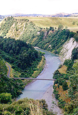
The Rangitīkei River is one of New Zealand's longest rivers, 253 kilometres (157 mi) long.

The Kaweka Range of mountains is located in inland Hawke's Bay in the eastern North Island of New Zealand. It forms part of the mountainous spine of the North Island which extends from Wellington to East Cape, including the Tararua and Ruahine ranges.
The Napier-Hastings Urban Area was defined by Statistics New Zealand as a main urban area of New Zealand that was based around the twin cities of Napier and Hastings in the Hawke's Bay Region. It was defined under the New Zealand Standard Areas Classification 1992 (NZSAC92), which has since been superseded by the Statistical Standard for Geographic Areas 2018 (SSGA18).

The Waipunga River is a tributary of the Mohaka River, located between Taupō and Napier in New Zealand's North Island. It runs roughly 50 km from its source near the eastern edge of the Volcanic Plateau to its junction with the Mohaka, of which some 15 km follow alongside the Napier-Taupō highway.
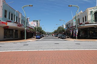
Heretaunga Street is the main arterial road through Hastings, New Zealand. The street forms the heart of the Central Business District of Hastings City across six blocks numbered 100, 200, and 300 Blocks with the railway line dividing the blocks by East and West. The name Heretaunga is taken from the name of the Māori Land Block on which Hastings was established in 1873.

Weber is a hamlet situated 28 km south-east of Dannevirke and 23 km WNW of Herbertville, on the east coast of New Zealand. Weber was named after the German born surveyor Charles H. Weber (*1830) who died during a surveying project near Woodville in 1886. His body was only found three years after his disappearance.
The Tutaekuri River flows eastward for 99.9 kilometres through the Hawke's Bay Region of the eastern North Island of New Zealand into the Pacific Ocean. It starts in the Kaweka Range roughly 50 kilometres north-east of Taihape, and reaches the sea just to the south of Napier, where the Ngaruroro and Clive Rivers join it.
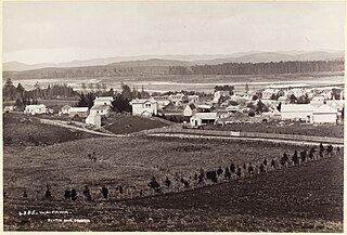
Te Pōhue is a small settlement in inland Hawke's Bay, in New Zealand's eastern North Island. It lies on State Highway 5, 31 kilometres inland from Whirinaki.
The Waipawa River is a braided river of southern Hawke's Bay, in New Zealand's eastern North Island. It flows southeast from the slopes of 1,687 m (5,535 ft) Te Atuaoparapara in the Ruahine Range, past the town of Waipawa, before joining the Tukituki River. The river rises at the 1,326 m (4,350 ft) Waipawa Saddle, which is also the source of the Waikamaka River. The Mangaonuku Stream is a tributary on the northern bank, west of Waipawa, near Ruataniwha. The Waipawa's flow is generally greater than that of the Tukituki River, into which it flows.

Waipātiki Beach is a small coastal village in the Hastings District and Hawke's Bay Region of New Zealand's North Island. It is situated in a little valley at the end of a road that branches off the main road from Napier to Gisborne and that finally, after 11 km, leads to a small sandy beach; first Tangoio Rd, then Waipātiki Road.
The Mangatera River is a river of the Manawatū-Whanganui region of New Zealand's North Island. It flows northwest from its origins in the Ruahine Range to reach the Rangitīkei River 25 kilometres (16 mi) east of Taihape.
The Maropea River is a river of the Manawatū-Whanganui region of New Zealand's North Island. It flows northwest from the Ruahine Range to join the Whakaurekou River 25 kilometres (16 mi) east of Taihape.
The Waikamaka River is a river of the Manawatū-Whanganui region of New Zealand's North Island. It is a tributary of the Whakaurekou River, part of the Rangitikei River system. The Waikamaka flows northwest from its sources in the Ruahine Range to reach the Whakaurekou 15 kilometres (9 mi) east of Taihape.
The Whakaurekou River is a river of the Manawatū-Whanganui region of New Zealand's North Island. It flows northwest from its origins in the Ruahine Range to reach the Rangitikei River 25 kilometres (16 mi) east of Taihape.
The Donald River is a river in the Hawke's Bay region of New Zealand. It flows southeast from the Kaweka Ranges in the Kaweka Forest Park, reaching the Tutaekuri River 20 kilometres (12 mi) west of Napier.

Park Island is the largest sports complex in Napier, New Zealand. It hosts clubs and facilities for association football (soccer), cricket, hockey, netball and rugby union. It includes Bluewater Stadium, a multi-purpose stadium that has a capacity of 5,000 people and opened in 1985. The stadium is used mostly for football matches and is the home stadium of Napier City Rovers and Hawke's Bay United. It also served as a training venue for teams in the 2011 Rugby World Cup.
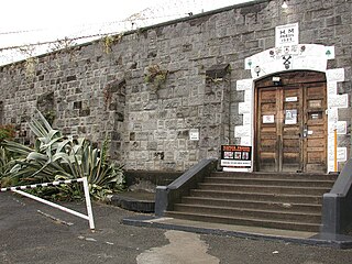
Napier Prison is a visitor attraction and former prison in Napier, New Zealand. Built in 1862 and decommissioned as a prison in 1993, it is the country's oldest prison complex.
Te Awa is a suburb of the city of Napier, in the Hawke's Bay region of New Zealand's eastern North Island.
Papanui Junction is a rural community in the Rangitikei District and Manawatū-Whanganui region of New Zealand's North Island. It is located west of Taihape, in the Turakina Valley.
