Akina, New Zealand

Last updated

Akina
Akina, New Zealand
Coordinates: 39°39′05″S176°50′44″E / 39.651266°S 176.845557°E / -39.651266; 176.845557
CountryNew Zealand
City Hastings
Local authority Hastings District Council
Electoral ward
  • Hastings-Havelock North General Ward
  • Takitimu Māori Ward
Area
[1]
  Land205 ha (507 acres)
Population
 (June 2023) [2]
  Total5,890
Raureka Hastings Central
Pfeil oben.svg
Pfeil links.svgAkinaPfeil rechts.svg
Pfeil unten.svg
Parkvale
Longlands Pukahu Havelock North

Akina is a suburb of Hastings City, in the Hawke's Bay Region of New Zealand's North Island.

Contents

The suburb includes Akina Park, Hawke's Bay soccer and softball park. [3]

Demographics

Akina covers 2.05 km2 (0.79 sq mi) [1] and had an estimated population of 5,890 as of June 2023, [2] with a population density of 2,873 people per km2.

Historical population
YearPop.±% p.a.
20064,626    
20134,821+0.59%
20185,193+1.50%
Source: [4]

Akina had a population of 5,193 at the 2018 New Zealand census, an increase of 372 people (7.7%) since the 2013 census, and an increase of 567 people (12.3%) since the 2006 census. There were 1,953 households, comprising 2,514 males and 2,679 females, giving a sex ratio of 0.94 males per female, with 1,158 people (22.3%) aged under 15 years, 1,077 (20.7%) aged 15 to 29, 2,283 (44.0%) aged 30 to 64, and 672 (12.9%) aged 65 or older.

Ethnicities were 68.6% European/Pākehā, 26.8% Māori, 5.4% Pacific peoples, 12.8% Asian, and 2.5% other ethnicities. People may identify with more than one ethnicity.

The percentage of people born overseas was 19.3, compared with 27.1% nationally.

Although some people chose not to answer the census's question about religious affiliation, 48.0% had no religion, 33.7% were Christian, 2.3% had Māori religious beliefs, 2.9% were Hindu, 1.2% were Muslim, 0.5% were Buddhist and 5.1% had other religions.

Of those at least 15 years old, 561 (13.9%) people had a bachelor's or higher degree, and 927 (23.0%) people had no formal qualifications. 291 people (7.2%) earned over $70,000 compared to 17.2% nationally. The employment status of those at least 15 was that 2,031 (50.3%) people were employed full-time, 579 (14.3%) were part-time, and 156 (3.9%) were unemployed. [4]

Individual statistical areas
NameArea
(km2)
PopulationDensity
(per km2)
HouseholdsMedian ageMedian
income
Akina Park1.032,3132,24691237.5 years$25,700 [5]
Parkhaven1.022,8802,8241,04132.7 years$27,300 [6]
New Zealand37.4 years$31,800

Education

Hastings Intermediate is a co-educational state intermediate school, serving Year 7–8, [7] [8] with a roll of 413 as of April 2023. [9] [10] The school opened in 1954. [11]

Hastings Christian School is a co-educational Year 1–13 state-integrated Christian school, [12] [13] with a roll of 327 as of April 2023. [9] [14] It started in 1987 as a primary school, and bought its current site in 1992. It provided secondary education for years 9 and 10 from 1998, and expanded to cover up to year 13 by 2010. [15]

Related Research Articles

<span class="mw-page-title-main">Cambridge, New Zealand</span> Town in Waikato, New Zealand

Cambridge is a town in the Waipa District of the Waikato region of the North Island of New Zealand. Situated 24 kilometres (15 mi) southeast of Hamilton, on the banks of the Waikato River, Cambridge is known as "The Town of Trees & Champions". The town has a population of 21,800, making it the largest town in the Waipa District, and the third largest urban area in the Waikato.

<span class="mw-page-title-main">Te Awamutu</span> Town in Waikato, New Zealand

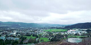
Te Awamutu is a town in the Waikato region in the North Island of New Zealand. It is the council seat of the Waipa District and serves as a service town for the farming communities which surround it. Te Awamutu is located some 30 kilometres (19 mi) south of Hamilton on State Highway 3, one of the two main routes south from Auckland and Hamilton.

<span class="mw-page-title-main">Morrinsville</span> Town in Waikato, New Zealand

Morrinsville is a provincial town in the Waikato region of New Zealand's North Island, with an estimated population of 8,960 as of June 2023. The town is located at the northern base of the Pakaroa Range, and on the south-western fringe of the Hauraki Plains. Morrinsville is around 33 kilometres east of Hamilton and 22 kilometres west of Te Aroha. The town is bordered by the Piako River to the east and the Waitakaruru Stream to the south.

<span class="mw-page-title-main">Richmond, New Zealand</span> Town in Tasman District, New Zealand

Richmond is a town and the seat of the Tasman District Council in New Zealand. It lies 13 kilometres (8 mi) south of Nelson in the South Island, close to the southern extremity of Tasman Bay. The town, first settled by Europeans in 1842, was named in 1854 after the town of Richmond on Thames near London. The town has an estimated population of 19,200 as of June 2023.

<span class="mw-page-title-main">Napier Hill</span> Suburb of Napier, New Zealand

Napier Hill is a limestone outcrop and suburb rising above the lowland districts of the city of Napier on New Zealand's North Island.

Hokowhitu is a riverside suburb of the New Zealand city of Palmerston North, with some of the highest property values in the city.

<span class="mw-page-title-main">Takaro</span> Suburb of Palmerston North

Takaro is a suburb and constituent ward of Palmerston North, Manawatū-Whanganui, New Zealand.

<span class="mw-page-title-main">West End, Palmerston North</span> Suburb of Palmerston North

West End is a suburb of the New Zealand city of Palmerston North.

<span class="mw-page-title-main">Cannons Creek, New Zealand</span> Suburb of Porirua City near Wellington, New Zealand

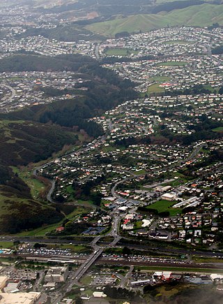
Cannons Creek is a suburb of Porirua City approximately 22km north of Wellington in New Zealand.

Onekawa is a suburb of the city of Napier, in the Hawke's Bay Region of the eastern North Island of New Zealand. Development of the suburb began in the late 1940s, after the land was acquired from then-Harbour Board.

Raureka is a suburb of Hastings City, in the Hawke's Bay Region of New Zealand's North Island.

<span class="mw-page-title-main">Hutt Central</span> Central business district of Lower Hutt, New Zealand

Hutt Central, a suburb of the city of Lower Hutt in New Zealand, forms part of the urban area of greater Wellington. It includes the Lower Hutt CBD.

<span class="mw-page-title-main">Newtown, New Zealand</span> Suburb of Wellington City, New Zealand

The suburb of Newtown lies in the southern part of Wellington in New Zealand. It lies east of Vogeltown, between Mount Cook and Berhampore. The main thoroughfares of Newtown are Riddiford St, leading from Mount Cook to Berhampore and Melrose, and Constable St, leading from Newtown to Kilbirnie.

<span class="mw-page-title-main">Nayland, New Zealand</span> Suburb of Nelson, New Zealand

Nayland is a suburb of Stoke, New Zealand. It lies to the north of Stoke, close to Nelson Airport, southwest of Nelson city centre.

<span class="mw-page-title-main">Nelson South</span> Suburb of Nelson, New Zealand

Nelson South is an inner suburb of Nelson, New Zealand. It lies to the southwest of Nelson city centre, between it and Bishopdale, close to the foot of The Grampians. The main inland route to Stoke, New Zealand, Waimea Road, is Nelson South's main road.

Elgin is a suburb of Gisborne, in the Gisborne District of New Zealand's North Island. It is located east and north of Awapuni, south of Te Hapara and west of Gisborne Central.

Camberley is a suburb of Hastings City, in the Hawke's Bay Region of New Zealand's North Island.

Mayfair is a suburb of Hastings City, in the Hawke's Bay Region of New Zealand's North Island.

Omanu is a beach and suburb in Tauranga, in the Bay of Plenty Region of New Zealand's North Island.

<span class="mw-page-title-main">College Estate</span> Suburb of Whanganui

College Estate is a suburb of Whanganui, in the Whanganui District and Manawatū-Whanganui region of New Zealand's North Island.

References

  1. 1 2 "ArcGIS Web Application". statsnz.maps.arcgis.com. Archived from the original on 14 February 2021. Retrieved 10 February 2023.
  2. 1 2 "Population estimate tables - NZ.Stat". Statistics New Zealand . Retrieved 25 October 2023.
  3. "Akina Park". hastingsdc.govt.nz. Hastings District Council. Archived from the original on 22 April 2019. Retrieved 9 June 2019.
  4. 1 2 "Statistical area 1 dataset for 2018 Census". Statistics New Zealand. March 2020. Akina Park (210700) and Parkhaven (211000).
  5. 2018 Census place summary: Akina Park
  6. 2018 Census place summary: Parkhaven
  7. "Hastings Intermediate Official School Website". hastingsintermediate.school.nz. Archived from the original on 9 June 2019. Retrieved 9 June 2019.
  8. "Hastings Intermediate Ministry of Education School Profile". educationcounts.govt.nz. Ministry of Education. Archived from the original on 10 June 2019. Retrieved 9 June 2019.
  9. 1 2 "New Zealand Schools Directory". New Zealand Ministry of Education. Retrieved 12 December 2022.
  10. "Hastings Intermediate Education Review Office Report". ero.govt.nz. Education Review Office. Archived from the original on 10 February 2023. Retrieved 10 February 2023.
  11. "Hastings Intermediate School Jubilee, 1954–1979". Knowledge Bank. Archived from the original on 10 February 2023. Retrieved 10 February 2023.
  12. "Hastings Christian School Official School Website". hcs.school.nz. Archived from the original on 9 June 2019. Retrieved 9 June 2019.
  13. "Hastings Christian School Ministry of Education School Profile". educationcounts.govt.nz. Ministry of Education. Archived from the original on 10 June 2019. Retrieved 9 June 2019.
  14. "Hastings Christian School Education Review Office Report". ero.govt.nz. Education Review Office. Archived from the original on 10 February 2023. Retrieved 10 February 2023.
  15. "History". Hastings Christian School. Archived from the original on 10 February 2023. Retrieved 10 February 2023.