Ngāti Kahungunu is a Māori iwi located along the eastern coast of the North Island of New Zealand. The iwi is traditionally centred in the Hawke's Bay and Wairārapa regions. The Kahungunu iwi also comprises 86 hapū (sub-tribes) and 90 marae.

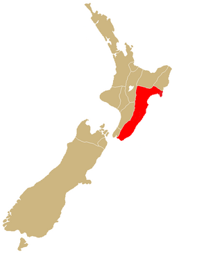
The Hawke's Bay Province was a province of New Zealand. The province separated from the Wellington Province following a meeting in Napier in February 1858, and existed until the abolition of provincial government in 1876. At the time of its establishment in 1858, the European population of the provincial district was only 1,185.
Architecture of New Zealand is the built environment of regions, cities and towns of New Zealand.

Reporoa is a rural community in Rotorua Lakes within the Waikato region of New Zealand's North Island.
Onekawa is a suburb of the city of Napier, in the Hawke's Bay Region of the eastern North Island of New Zealand. Development of the suburb began in the late 1940s, after the land was acquired from then-Harbour Board.
Te Pōhue is a small settlement in inland Hawke's Bay, in New Zealand's eastern North Island. It lies on State Highway 5, 31 kilometres inland from Whirinaki.
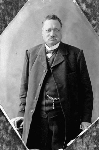
Henare Tomoana was a prominent Māori leader and politician from the Hawke's Bay area in the North Island, New Zealand. He was of Ngāti Kahungunu and Ngāti Te Whatu-i-Apiti tribal lineage. In 1879 he was elected to the New Zealand Parliament for the Eastern Maori electorate, and in 1898 was appointed to the New Zealand Legislative Council. He was a convenor of Te Kotahitanga, the movement for an independent Māori Parliament.
Omanaia is a settlement in the Hokianga area of Northland, New Zealand. It is part of the Hokianga South statistical area, which covers the southern side of Hokianga Harbour between Rawene and Koutu. For demographics of this area, see Rawene.

Tokaanu is a small settlement close to Tūrangi at the southern end of Lake Taupō.
Te Mātenga Taiaroa was a leader of Ngāi Tahu, a Māori iwi (tribe) of the South Island of New Zealand. Taiaroa belonged to Ngāi Te Ruahikihiki and Ngāti Moki hapū of Ngāi Tahu, which were centred on Taumutu, at the southern end of Lake Ellesmere / Te Waihora. From the 1830s to the 1860s, he was a leader at Ōtākou on the Otago Peninsula in association with his cousin Karetai. in the 1830s he fought against Te Rauparaha and Ngāti Toa, sometimes in conjunction with Tūhawaiki. He was later involved in peacemaking with Ngāti Toa. In 1856 he attended the meeting of Māori chiefs at Pūkawa, Lake Taupō, which elected Pōtatau Te Wherowhero as the first Māori King. In 1860 he attended the Kohimarama conference of Māori chiefs in Auckland, organised by the government. In 1859 Taiaroa was baptised by a Methodist minister and took the Christian name of Te Mātenga (Marsden). Hōri Kerei Taiaroa was one of his children.

Sir Tumu Te Heuheu Tūkino VIII is a New Zealand Māori tribal leader. He is the eighth elected paramount chief of the Ngāti Tūwharetoa iwi in the central North Island, and an influential figure among Māori people throughout New Zealand.
Opepe was a settlement in New Zealand, a few miles southeast of Taupō. It was the scene of an attack on European militia by Maori on 7 June 1869, in which nine members of the militia were killed.
The 2009 Queen's Birthday Honours in New Zealand, celebrating the official birthday of Queen Elizabeth II, were appointments made by the Queen in her right as Queen of New Zealand, on the advice of the New Zealand government, to various orders and honours to reward and highlight good works by New Zealanders. They were announced on 1 June 2009.

Otamarakau is a beach and community in the Western Bay of Plenty District and Bay of Plenty Region of New Zealand's North Island, just south of Pukehina.
Waihāhā is a village and rural community in the Taupō District and Waikato region of New Zealand's North Island.
Oruanui is a rural community in the Taupō District and Waikato region of New Zealand's North Island, located northwest of Wairakei on State Highway 1.
Puketotara is a rural community in the Otorohanga District and Waikato region of New Zealand's North Island.
Te Awa is a suburb of the city of Napier, in the Hawke's Bay region of New Zealand's eastern North Island.
Omahu is a village in the Hastings District and Hawke's Bay Region of New Zealand's North Island. It is located on State Highway 50, north-west of Hastings on the north bank of the Ngaruroro River.

Taupō Central is the central suburb and business district of Taupō in the Waikato region of New Zealand's North Island.
